The Bowen-Baker trailhead is about eight miles north of the west side entrance station. The small parking lot is just a few yards off the highway. A dirt road crosses the broad, flat valley where there is parking for a dozen or so vehicles. I parked in the paved parking lot; didn’t even consider driving farther. I was here last spring and the gate was closed, the road flooded with 4-6 inches of water.
After less than a mile of hiking, the trail leaves the park and enters the Never Summer Wilderness. The trail initially follows the stream but before long climbs the north side of the valley. Soon you reach a place where the trail was washed out last spring in a flash flood. A small alluvial fan lies a few yards below the trail. It’s not clear to me what caused the flood. There’s a small trickle of water that flows down the mountain here, but it’s not even big enough that when the trail was repaired any culvert or pipe was put in place.
The trail continues up the valley, far enough up the hillside that the stream is out of earshot. The climb is steady, but not steep. In the more forested parts, the trail is often free of roots and rocks, making for very easy walking. The view of the area opens when crossing a tumble of talus. Above you can make out the scar of the Grand Ditch. A view of the south side of the valley is presented. Avalanche zones are obvious – in places, I figure any standing trees to be less than thirty years old, judging by the size of growth in the burned areas on the Ouzel Lake trail in Wild Basin.
After passing through another stretch of forested trail, the trees again thin out. This is an avalanche zone on this side of the valley. Many trees are no longer standing straight up, but are canted at angles downhill. Other trees were recently snapped off about six feet above ground. I’m guessing much of this damage occurred last spring. From the views, it’s obvious that avalanches are a not uncommon occurrence up and down this valley.
The trail continues to climb, perhaps a bit more steeply now, until it reaches the Grand Ditch. The ditch reminds me of the Highline Canal in the Denver suburbs, capable of carrying quite a bit of water with a dirt service road running along side it. The trail continues on the other side of the ditch about a hundred yards to the west. There’s a simple twin log bridge spanning the ditch, but neither this summer nor last spring was there any water in it.
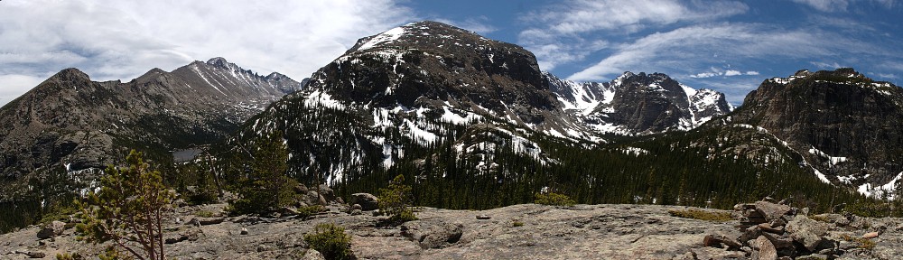
A bit farther up the trail the forest again clears revealing a pretty meadow just to the south and giving a nice view of point 12440 to the west and Bowen Mountain (12,524′) to the southwest with its craggy ridge running to the east. In the distance to the east, Long’s Peak stands like an erect nipple above the surrounding terrain. Here there are two streams to cross. At this time of year, you don’t even run the risk of getting wet feet but in spring at peak runoff they may present a bit more of a challenge. Between the stream crossing is a trail junction. To the left is Parika Lake and the Baker Pass trail to the right.

Point 12440 from first stream crossing
Last spring when I attempted this hike, I stopped here for my picnic and went no further. I had gotten a late start and wasn’t feeling all that well and decided that this was a pleasant place to watch the clouds scroll over the pyramid shaped north eastern flank of the unnamed mountain (point 12,440′) and listen to the rushing of the stream. This day, I didn’t pause here. I saw some moose footprints but didn’t see any of the beasties.
At this point the trail starts getting steep, climbing about four hundred feet in a half mile or so, arriving at another meadow. A nice little pond lies a few yards to the north of the trail. After this respite, the next section of trail makes another four hundred foot climb and the hiker is deposited at the eastern shore of Parika Lake. There’s a sign here saying that fires are not allowed past this point, but that prohibition is clearly ignored.
The trail seems to peter out here. I startled a group of marmots who were grazing here, sending them scurrying off to hide in the rocks. Actually, the trail crosses the outlet and continues up the flank of Fairview Mtn (12,246′) , crossing to the saddle between it and Parika Peak (12,392′). This trail is clearly visible from the shore of the lake where I sat and ate my lunch.
Parika Lake sits in a bit of a bowl at about 11,400′. Unlike most alpine lakes in RMNP which are surrounded by craggy, rocky peaks with often stark vertical faces, Parika Lake lies in the arms of tundra covered, (relatively) gently sloping mountains. It isn’t quite above treeline, but there are only a few small clumps of trees in the area.
After my luncheon, I stood on a rock outcropping and watched the family of marmots grazing where I first encountered them. They kept an eye on me as well. My SLR is in the shop for cleaning, so I didn’t have my telephoto lens. My wife’s little digicam has an optical zoom, but it’s not good for scanning for distant quadrupeds. Whether it was their absence or the camera, I didn’t see any goats or sheep or moose or elk. Just the marmots.
The weather was very nice. It was a bit cool when I started (8:15) but with the sunshine and activity I didn’t need a jacket. As the morning progressed, I wondered a bit if I would get any clouds at all. While picnicking and running the camera for the time lapse, the wind kicked up and the clouds began to darken to the point where I decided I didn’t need to sit there for a full hour. By the time I was back to the Baker Pass trail junction, the vaguely threatening clouds had broken up and the remainder of the day featured ideal weather.
Depending on the source, I’ve seen distances between 10.1 and 10.8 miles for this hike, with a vertical climb of about 2,500′. Being as I was parked close to the road, I’ll go with the longer distance. I hit the trail at 8:15 and took a 40 minute break at the lake and a 20 minute break at the trail junction on the way down. I returned to the car at 3:00pm. Even with the longer drive to and from the trailhead, it wasn’t too taxing a day.
From the Denver area, I took I-70 and Berthoud pass on the way there and Trail Ridge Road and US 36 on the way back. A bit over 2 hours in the morning, but given typical Sunday afternoon traffic on I-70 didn’t want to go home that way. By the way, some aspen are already turning on the east side of TRR. Maybe I’ve never paid that much attention, but I don’t recall seing them turn in August. I guess this is one sign of the current drought conditions. Not many are turning, but it’s not limited to a particular area, it’s happening all along the road.
The time lapse: