September 5, 2014
My preferred breakfast is a bagel and some fresh fruit. This sort of fare is generally available in the “continental breakfast” included in many hotels and motels. Unfortunately, on this trip it has never been available. The motels I’ve been staying in have offered waffles and cereal. This morning they had sausage gravy and biscuits which I found acceptable.
According to Google, my route today would be eleven hours of driving. Add breaks for food and fuel and I could expect to be on the road for more like thirteen hours. Even more, if I found some interesting diversion. With that in mind, I was packed up and out the door shortly before seven.
A few minutes later I crossed the Columbia for the sixth time on this trip. Soon after crossing the Columbia, I cross the Snake just above where it joins the Columbia. My first crossing of the Snake was back on day 1 in Blackfoot, ID. I will cross it a few more times in the next couple of days.
I headed east on US 12 a few miles until I turned east on WA 124. I could have stayed on US 12 but WA 124 meets up with it later, cuts a few miles off and skips a trip through Walla Walla. Being a state route, it should also carry less traffic. This trip has certainly increased my appreciation for the road less traveled. It passes through farmland to start – corn, alfalfa, grape vineyards, and apple orchards. As we climb out of the valley the terrain turns to straw colored rolling hills.
I regain US 12 in Waitsburg and continue east. I find myself back on the Lewis and Clark Trail, which I will follow on US 12 for most of the day. The road is fairly pleasant through this part of Washington. Not heavily traveled, not too straight, not very twisty, with enough change in scenery to remain interesting. I refueled in Clarkston (WA), then crossed the Snake again into Lewiston (ID). I missed a turn here, seeing the route marker too late to change lanes. The road essentially does a 360.
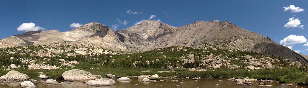
For the first time today I found myself in traffic. Exiting Lewiston, the road crosses the Clearwater River, which US 12 follows to the top of Lolo Pass. That’s not entirely true – the road runs along the Lochsa River the last several miles up to the pass; the Lochsa and Selway Rivers join to form the Middle Fork Clearwater River. Anyway, there’s a fair amount of traffic for a while, but it cleared up gradually while at the same time the canyon become more scenic. The Clearwater River is aptly named – clear water flows through a broad, shallow watercourse with few rapids.
Thinking it’s about time for a break, I grab for my water bottle. It’s lighter than I expected. My backpack, sitting in the passenger seat, is damp. Not a good sign. I almost immediately arrive at the Fish Creek river access and pull over. The passenger seat is soaked so I unpack it and move the car so the seat is in the sun. I didn’t really mean to take an extended break, but so it goes. I rested there for about an hour.
I went down to the river and watched a couple of fly fishermen for a while. Back at the car to see how things are drying out, three motorcycles arrive, one with a passenger. I’m checking my stuff as they pull in. I’m not watching them but hear them get closer. Then there’s a nasty grinding noise. The rider with passenger dropped his bike. She’s sprawled face down, luckily not under the bike. It takes 3 of us to set the bike up. She’s okay, walks it off (with a limp). The bike is a bit scratched up now, but no serious damage.
We chat for a while. The three guys are all 72 years old. One has a pretty thick New York accent. I say “It doesn’t sound like you’re from these parts.” He lives in Reno; his friends call him New York George. “Twenty seven years in Reno, when are you gonna let me in the club?” They ask about my trip, I tell them. New York George tells of his friend currently riding across Russia, westbound from Vladivostok. He’s with a friend, a former Secret Service agent and they’re a month and a half into their planned three month trip. His friend’s previous trip was from Alaska to Patagonia. It sounds to me like a great way to spend retirement.
As they leave, a solo rider arrives. I didn’t get his name, I’ll call him Hank. We talk a bit about fun roads in the area. He recommends the Greer Grade. I’m not sure if I’ll be back in this area in the Lotus, but it doesn’t hurt to take notes. He also recommended a restaurant about ten miles this side of Lolo summit – the Lochsa Lodge. He leaves before I do, but I tell him if he’s still there when I arrive we’ll chat some more.
All trip I’ve been very good about not going more than 5-8 miles per hour over the limit. Here, I was idling along in sixth gear with a posted limit of 50. I found myself at 57 for a while, but it would creep up to 62 and I’d slow back down. I’ll blame it on subtle changes in the grade. I kept doing this, unable to keep to 58. I passed an SUV, then a semi. Around another bend I see I’m catching up to another SUV, who immediately pulls aside. I’m thinking “nice guy, getting out of my way like that.” Until I saw that it’s a State Trooper.
 He pulled me over and cited me for 63 in a 50 zone. He said he always writes anything eight and over. “I have no doubt your car would easily do eighty, but you never know what’s around the next corner. Could be a truck, could be a moose.”
What I didn’t know until later was that the speed limit on the Montana side is 70, except for the steepest first mile where it is 60. The road is fundamentally the same – the curves are about the same radii, the grade is pretty much the same. If it’s safe to go 70 there, it’s safe to go 70 here. And if it’s safe to go 70, it’s safe to go 63.
I found the Lochsa Lodge, It was a very pleasant day, so I headed for the outside seating. Hank was there in a shady corner, just finishing his lunch. I sat with him and ordered lunch and a tasty local beer. The first topic of conversation was my ticket. He said he went 75 and was passed by other bikes with no sign of cops. He passed westbound bikes but none gave him any warning signal.
We talked about forest fires. Some of his favorite rides have had significant fires the last few years. We exchanged stories of the various desolate routes we’ve taken. He told me about riding with his wife, getting caught in a cold rain, nearly out of gas on a deserted highway in Nevada. I told him about the hundreds of shoes hanging on a chain link fence around a deserted gas station fifty miles from nowhere in the California desert east of Joshua Tree.
Back on the road my first stop was almost immediate: Lolo Pass. It was crossed by Lewis and Clark westbound in September of 1805 and again eastbound in June of 1806. There is much debate about the name. Some insist it is Nez Perce for “muddy water” while others believe it is a Flathead version of “Lawrence”. Those with no imagination say it’s just “low-low” because the traverse is low. But I’ve also heard that it’s a mistranscription of Lieutenant G. K. Warren’s map from 1857. There, it’s actually “LoCo”.
 After the summit of Lolo pass it was down the eastern side to Lolo, MT, my next navigation point and pit stop. A good sized area on the north side of the highway was burned. It looked fairly recent to me, perhaps in the last year or two I thought. Then I came across two houses being rebuilt, so it was probably quite recent. Near Lolo there are other burn scars, perhaps 5 or 10 years old. I gassed up and headed south on US 93.
US 93 goes over Lost Trail Pass, back into Idaho for me. Lost Trail doesn’t cross the Continental Divide, which is just a few hundred feed to the west. Although we’re no longer on US 12, we are still on the Lewis and Clark trail. They crossed Lost Trail pass from south to north, entering the Bitterroot valley. I found it a much more enjoyable drive than Lolo pass; it’s steeper and has sharper turns. But like Lolo, it was more fun in Montana than Idaho. As soon as you crest the pass, the speed limit drops significantly. Back in Idaho I kept an eagle eye on the speedometer.
The road flattens and straightens towards Salmon. I had a light dinner at Bertram’s Brewery. I also had a momentary confusion as to the time. I thought it was seven but my phone said eight. I hadn’t realized I’d returned to Mountain time. Heading back to the car I see I was parked 3 spots away from a nice looking Austin Healy. The owners walked up just as I was about to start up. “Is that a Lotus?” “Yes” “What year?” “’06. What year’s yours?” “66. Austin Healy”
Here in Salmon I quit US 93 and head south on ID 28, just after sunset. I pulled off the road for a quick second at a commercial driveway in the middle of nowhere. Over the idling of the car I could hear coyotes.
This was the only part of the trip where I doubted my navigation. I only used the phone’s navigation for finding addresses, not general route finding. Each morning I took notes from the atlas. I rarely noted the distance between points unless it was quite far. For some reason, I was thinking it was only another hour and a half to Rexburg when in fact it was two and a half.
I was quite sleepy as I had trouble falling asleep the night before, which didn’t help with my miscalculation on the timing. On the positive side, I figure I didn’t miss much scenery as the road is dead straight most of the time. Early on, I saw one sign for Rexburg but it wasn’t listed on the next three or four distance signs. I was expecting to junction with ID 33 by 9:30 but was still looking for it at 10:30. By then I was sure I’d missed it. There was no sign of civilization other than the faint glimmer of Idaho Falls over the horizon. I knew I had to be close, as I was seeing signs for INR like I did on US 20 near EBR-I on day 1. Turns out there was no way to miss the junction with ID 33 as it’s a T-intersection. I made the left turn and the next sign tells me it’s 32 miles to Rexburg.
As I pulled in to the motel parking lot, the low fuel indicator lights up.
Almost all of today’s drive was along the Lewis and Clark trail. Parts are Nez Perce trail as well.