Today I return to the Hessie Trailhead in the Indian Peaks Wilderness for a walk up to Jasper Lake and its surroundings. There are three lakes here: Jasper Lake, Storm Lake, and Devils Thumb Lake. There are more than those, actually, as there are three unnamed ponds and a small lake called Upper Storm Lake in the cirque above Storm Lake. There is no official trail from Lake Jasper to Storm Lake and above.
Theoretically, it might be possible to visit these three lakes in one day hike. But because I haven’t been there before and I don’t know what the terrain looks like between Jasper and Storm, I decided to go to Devils Thumb Lake. On the return trip, I’d stop at Jasper and do a little recon of the route to Storm.
Wednesday, September 7
Arriving at the trailhead at about 7 am worked well for me on my first hike from Hessie, so I stuck to that plan. Today I had to gas up the car and the station doesn’t open until 6, so I arrived at the trailhead just a few minutes later than planned.
On my previous Hessie hike, I logged my time at each waypoint. I skipped a few this time, as there aren’t any navigational choices between the car and where I leave the jeep trail and take the Devils Thumb Bypass trail to reach Devils Thumb Lake. The Devils Thumb Bypass trail parallels the Woodland Lake trail, the trails being on opposite sides of Jasper Creek. Although the trails are only a few hundred feet apart, the forest is dense enough that I never saw the other trail. The first hundred yards or so of the bypass trail is the steepest section of trail on the entire hike.
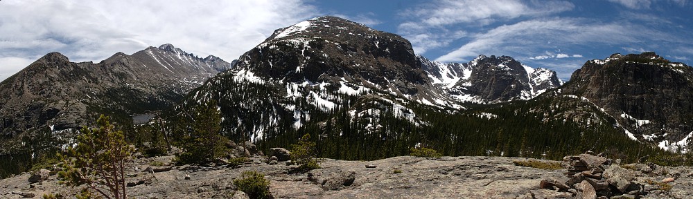
On this trail, you reach the IPW boundary sign in a large meadow about a hundred yards wide and a third of a mile long. The meadow affords the hiker of the first views of Mount Jasper. This section of trail is the easiest: almost flat and almost entirely free of roots and rocks, allowing the hiker to maintain a uniform stride. Too quickly, perhaps, the trail returns to the forest.
It seems that for much of the route from the IPW boundary to Jasper Lake, the trail follows an old roadbed. Jasper Lake is a functioning reservoir. I was unable to find out anything about when it was built, but it’s an earthen berm dam much like several of the (now removed) dams in RMNP. I assume it is of about the same vintage, or just over a century old, and that this old road was used in the dam’s construction.
Anyway, the trail doesn’t always follow the old roadbed. Occasionally, there are small signs along the trail that say “Trail →”. I found these little signs a bit odd, as any other option than following the arrow on the sign would be silly. And yet, once I somehow managed to note the sign but still go off in the wrong direction.
I found myself still on the old roadbed, on a somewhat steep section of it bounded on both sides by willow. The road itself was now a corduroy road: made of logs the width of the road, placed side-by-side. I usually read of these corduroy roads being built in low, swampy areas. This section isn’t in a low area and is somewhat steep. Conversely, willow tends to grow in wetter areas, so the area may be quite wet earlier in the season. By the looks of it, there’s a fair amount of foot traffic through here, so I’m not the only one who has errantly gone this way.
A bit farther up the trail is the junction with a trail to Diamond Lake. Diamond Lake is a fairly short hike when starting on the Fourth of July trailhead. From there, it’s a bit more than two and a half miles. This way, it’s perhaps three times that, plus an extra six or seven hundred vertical feet. A good stretch of this route is above timberline, so the open views may make the extra effort worthwhile.
Slightly more than half a mile further on, the trail reaches the outlet of Jasper Lake. I didn’t pause here but trekked on toward Devils Thumb Lake. I would stop here on the way back.
From Jasper to Devils Thumb, the forest thins. Or, perhaps, it would be more accurate to say we’re hiking through grassy areas with clumps of trees rather than forest with clearings. In any event, Devils Thumb and Skyscraper Peak and parts of the Continental Divide are often in view.
The trail soon climbs to and crosses the outlet of Devils Thumb Lake. The lake is about ten acres in area, maybe 425 feet wide at its widest (north to south) and a quarter of a mile in length east to west. It is bounded on the east and west by large, thick stands of willow while the north shore is a tumble of talus. That leaves the south shore as the most easily explored. This shore is covered with forest, and the banks are more steep than flat. If you go down to the water, you can find a view of the entire lake, but the only places I found to sit in the sun and relax offered only partial views of the lake.
I spent about an hour here, between my search for a comfy spot to relax, consumption of a small snack, and application of sunscreen.
At this altitude (and for much of the hike, frankly), most of the wildflowers are gone, either eaten by squirrels or cached in burrows. The only flowers still with blooms were a few yellow species. All the blue, red, and purple were gone. I didn’t see a single columbine on the entire hike.
The relative lack of wildflowers wasn’t the only sign of the changing season. The grasses were beginning to turn yellow, and while the aspen leaves are still green, the ground cover beneath the aspen was already golden.
From the car to Devils Thumb Lake, I encountered only one other hiker. I started seeing more people once I started my return trip. Two sets of two hikers between Devils Thumb and Jasper told me to be on the lookout for a mother moose and her calf. I never spotted any moose, elk, or deer the whole day.
Back at Jasper, I turned off on a spur trail that leads to a few of the campsites. I went far enough along this trail to decide that this is the way to go if you want to head up to Storm Lake. This trail runs along the western shore of the lake, just high enough up the slope to avoid any marshy areas along the shore. I hopped off the trail here to explore a peninsula. I don’t think maps accurately depict the shape of the lake. This is probably because the shape of the lake changes drastically when it’s not full.
Much of the shoreline of the lake is forest, with steep banks. It’s a very scenic lake. At the farthest extent of my peninsula, I found a nice spot for a picnic and had my lunch. I had a nice open view of the corrugated ridge north of the lake. I also had a view of the terrain leading up to Storm Lake and could see a couple of falls made by its outlet stream.
Today’s beer was Hazy IPA by Great Divide Brewing Company. I’m not a huge IPA fan, but when you buy a variety pack you take the non-favorites with the favorites. I selected this particular beer today because I expected the skies to be a bit on the hazy side – an effect of wildfires in the Pacific Northwest. The IPA was a nice change of pace from my recent string of sour fruit ales, and the hazy skies were noticeable but not terribly bad.
Last week, I found myself directly underneath a flight path for eastbound jetliners. It turns out that Jasper Lake is directly beneath a westbound flight path. Like last time, atmospheric conditions were such that these planes weren’t leaving any contrails so I had a little trouble initially spotting them. As they all use the same routes, when you spot one, you can spot them all. Being a city dweller near a regional airport, I’m accustomed to hearing aircraft all the time. But they don’t fly right over my house. If these jets didn’t fly right overhead, I don’t know that I’d be complaining about them.
Here in the first week of September, Jasper Lake is at its fullest. What looks today like the outlet of the lake is actually the dam’s spillway. Some care was taken to make it look natural. The same is true, to an extent, of the dam itself. From below the dam, on the trail, it’s not obvious that it’s a dam. The slope is gentle and is covered with grass (and flowers, perhaps, in July and August).
The water that goes over the spillway makes a 90-degree turn then drops fifteen feet or so to where I’m guessing the original outlet of the lake was. The outlet pipe is here. Once the valve is opened, the lake’s level will drop such that water no longer goes over the spillway; the lake is drained through this pipe. There’s a building of some sort (I didn’t explore it) where I assume the valve is operated.


I’m guessing this dam was built much the same way as the (no longer standing) dams for Sandbeach, Lawn, and Pear Lakes (and others) in RMNP. I can only hope that its construction is more robust than those dams (which, by 1982, all suffered serious structural issues). I understand that dams in Colorado are rated as to their riskiness. This rating is based on the danger to people and structures below the dam should it fail and not just on the soundness (or lack thereof) of the dam itself. If this dam were to fail, it would flood Middle Boulder Creek through the town of Eldora, then Nederland, and ultimately flow into Barker Reservoir.
I ran into a lot more trail traffic on the way out than on the way in. More than half the folks I encountered had dogs with them. There are plenty of signs that tell us dogs must be on leashes. Of all the dogs I saw, only one group kept theirs leashed. All the rest allowed their dogs to run free. One group at least made the attempt to seem like they kept their dogs leashed: they managed to get one of their two on a leash by the time they passed me. But a hundred feet past me, they let that one off to run free. (There was a fair amount of dog poo right on the trail, too.)
I’m sure every dog owner feels that their Fido is a kind, gentle dog not very interested in biting people. But on my daily walks in my neighborhood, I’ve been bitten multiple times by dogs. Back in my misspent youth, when I delivered Avon to the Avon ladies, I encountered hundreds of vicious dogs. So perhaps I’m oversensitive to the issue. But I really wish people would follow the rules on this one and keep Rover on a leash.
I will definitely be back in this area. I’d like to visit Storm Lake (and perhaps Upper Storm Lake and the unnamed ponds, too). In the valley between Jasper and Betty and Bob Lakes, there are two more lakes, one of which is also a reservoir. Skyscraper Reservoir looks to be a concrete dam rather than an earthen berm. I probably won’t get to Skyscraper this season, but it’s definitely on the to-do list. I’ll admit that I’m curious about these alpine lakes that were dammed in service of irrigating farms on the eastern plains.
Hike Segment Data
| Start | End | Distance (Miles) | Slope (Ft/Mile) | Elapsed Time | Miles per Hour |
|---|---|---|---|---|---|
| Car | Devils Thumb Bypass jct | 1.5 | 297 | :36 | 2.5 |
| Devils Thumb Bypass jct | IPW Boundary | 0.5 | 380 | :15 | 2.0 |
| IPW Boundary | Woodland Lake trail jct | 0.8 | 201 | :20 | 2.4 |
| Woodland Lake trail jct | Diamond Lake trail jct | 1.5 | 593 | :49 | 1.8 |
| Diamond Lake trail jct | Jasper Lake | 0.6 | 223 | :20 | 1.8 |
| Jasper Lake | Devils Thumb Lake | 1.0 | 325 | :36 | 1.7 |
| Car | Devils Thumb Lake | 5.9 | 364 | 2:56 | 2.0 |