Sunday, June 16
Tourmaline is a gemstone that comes in a wide variety of colors. More technically, tourmaline is a crystal boron silicate mineral compounded with elements such as aluminum, iron, magnesium, sodium, lithium, or potassium. Whatever that means. Was the lake given this name because tourmaline can be found there, or because of the color? I have no idea.
There are two obvious routes to reach Tourmaline Lake. In either case, you get there by visiting Odessa Lake first, meaning you can start either at Bear Lake or the Fern Lake trailhead. It is nearly a mile shorter starting from Bear Lake, but I chose to start at the Fern Lake trailhead for two reasons. First, the trail from Bear Lake descends about 500′ between Lake Helene and Odessa Lake, meaning I’d have to do an uphill stretch on the way back. I like to get most of my uphill hiking done before lunch. Second, and more importantly, I haven’t hiked from the Fern Lake trailhead since last fall’s fire.
The fire started on October 9 in rugged terrain near the Pool. It was still burning November 30 when seventy mile per hour winds pushed it to Moraine Park. Except for a small stand of trees damaged on the south side, Moraine Park looks almost untouched by the fire – the grass is regrown and although many of the shrubs along the stream were burned many of them are now sprouting green leaves. It appears to me that many of those shrubs have black bark on the trunks (stems?) so it may be that fewer of them burned than I originally surmised.
I arrived at the trailhead shortly after eight and was on the trail by 8:20. It was a pleasant sunny morning. Forecast for Denver was a high of 84, so I figured maybe ten degrees cooler at the trailhead and another few degrees at Tourmaline. The weather report suggested a fifty percent chance of rain. But at eight, there were no clouds in the sky and no wind to speak of.

Burned area south of the Big Thompson
Within a couple hundred yards of the trailhead, I could see large burned areas across the river on the south side of the valley. In my mind, I always felt the section of this trail, from the trailhead to the Pool, is very similar to the lower section of the Thunder Lake trail in Wild Basin. Both run alongside the north bank of a large, boisterous stream and have very gentle gradients. On the Thunder Lake trail, you don’t get to the burn area of the Ouzel fire until well after you cross the river. On the Fern Lake trail, there is very little fire damage on the trail itself. There are a few small burned spots right along the trail before arriving at the Pool.

Looking towards Trail Ridge Road
At the Pool, the trail crosses to the south side of the Big Thompson and splits: Cub Lake to the left, Fern Lake up and to the right. Not long after that junction, the Fern Lake trail crosses Fern Creek. This crossing is a simple log bridge – two logs side by side, cut flat for a walkway, with a smaller log serving as a railing. Here the fire crossed the creek with burned trees and blackened ground on both sides of the creek. But the bridge was, strangely, untouched. From here the trail climbs steadily and zig-zags a couple of times reaching Fern Falls before finally flattening and straightening on the final approach to Fern Lake. At times the hiker is presented with a view of the terrain on the north side of the valley. That is where most of the fire burned, all the way up to the tree line.
I didn’t see any snow on the ground until reaching Fern Lake, where a snow bank covered the trail. By now the skies along the divide were no longer blue. Trying to be witty I might say the weather performed alchemy, transforming cobalt to lead. But the clouds weren’t that gray. At Fern Lake the trail crosses the outlet then passes through a boulder field before regaining the forest. From here to the Odessa Lake spur, the trail climbs steadily and provides the occasional view of Fern Lake through the trees.
The spur trail to Odessa Lake crosses the stream once again. The trail here is quite close to the stream. There is quite a bit of runoff and the trail here is wet and muddy. The trail dumps you at the northern end of the lake with a nice view of Notchtop. To get to Tourmaline Lake, circle to the west and south until reaching Tourmaline Creek. From here, there’s not much of a trail. Just follow the stream. I occasionally found a faint trail or a few cairns, but that was the exception.
The hike gets steep here. From trailhead to Tourmaline Lake the total elevation gain is 2,470′ over 5.4 miles. But the elevation gain from Odessa to Tourmaline is 560′ of that and in only about a half mile. The stream falls down the mountainside in braids and quite often underneath piles of boulders. I took my time on the steep parts, taking in the view of Joe Mills Mountain. The trail from Odessa to Bear Lake is a visible gash on the far side of the valley.
Here the clouds got productive. After one steep ascent the route flattens out a bit. This is where the graupel started falling. Neither snow nor hail, but something in between it melted fairly quickly when it hit the boulders, making them somewhat slippery. I put my windbreaker on (just shorts and Hawaiian shirt necessary until now) and the little pellets were now quite audible. After a short while the trail gets steep again for the final assault on the lake. There was some snow on the ground. I came prepared with micro spikes but never put them on. I postholed in a couple of places but the snow wasn’t much of an issue.

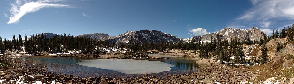
Tourmaline pano
Arriving at the lake, I set up the GoPro for a timelapse before tucking in to my picnic lunch. The sky was solid formless cloud with no apparent motion. I let the camera run anyway, as you never know what you’ll get. (In this case, I got nothing. So no time lapse video for this lake. Yet.) But because of the clouds, I didn’t bother setting up the SLR for a time lapse and instead climbed up a pile of boulders in an attempt to get a nicer angle.

Tourmaline Lake
Seems a turkey sandwich always tastes better when I’m sitting at an alpine lake, even if it has been slightly smashed in the pack. And even if the clouds are starting to look a bit threatening. I didn’t dawdle long. I often linger for an hour or so, to make sure I take in all I can. But I didn’t like the looks of things, so I packed up and headed down the mountain. Just in time to get graupeled on again. I managed to retrace my steps, finding most of the trail fragments and cairns I saw on the way up.
On the final steep part before reaching Odessa, the precipitation changed to rain and thunder started rumbling through the valley. At first, it was just a light sprinkle but by the time I reached Odessa I decided it was more likely to get worse before it got better so I dug the poncho out of the pack. It rained steadily from there to Fern Lake, then only lightly until clearing up at Fern Falls.

Rain lashes Fern Lake
Not long after Fern Falls, the clouds had completely disappeared.
I took a number of photos of the burned sections right along the trail, but most of them are not very interesting – or perhaps misleading. Posting a few pictures of burned trees along the trail may give the impression there’s more damage than there really is. As I said earlier, it is often just a few feet of burn where the fire crossed the trail. But I will post one more, a panorama built from three photos around a bend in the trail. Note that the trees appear undamaged; only the deadfall actually burned.

Burned section of trail
All in all, a quite enjoyable hike. I’d like to revisit the lake with better weather, perhaps next time from Bear Lake.
Timetable
| There | Back | |
| Trailhead | 08:20:00 AM | 03:50:00 PM |
| The Pool | 09:00:00 AM | 03:05:00 PM |
| Fern Lake | 10:10:00 AM | 02:00:00 PM |
| Odessa Lake | 11:00:00 AM | 01:30:00 PM |
| Tourmaline Lake | 12:10:00 PM | 12:55:00 PM |


