Herman Lake sits at the head of a valley below the continental divide between Citadel Peak and Pettingell Peak. It’s a high lake, just a few feet below 12,000′. It is reached from the Herman Gulch trailhead at exit 218 on I-70, the last exit (westbound) before the Eisenhower Tunnel.
There’s a Pettingell Lake in Rocky Mountain National Park. Both the peak and the lake are named after Jacob Pettingell. He moved to Grand County back in 1880 at the age of 20 and served as postmaster, notary public, insurance agent, legal counsel, justice of the peace, and county clerk. One of these days I hope to hike to the lake, but I’ll probably not climb the peak.
Different websites give different distances for this hike, between 2.5 and 3.4 miles each way. Elevation gain is about 1,700′. Much of the trail is fairly level but bookended with steep sections. The first half mile or so of the trail gains about five hundred feet, and there’s another section, about six-tenths of a mile near the end that gains another six hundred feet. I would call this a moderately strenuous hike, but some sources call it “strenuous” due to these two steeper sections.
Friday, July 21
This is my first time for this hike, and I’ve read a number of trip reports saying that the parking lot fills up early. I arrived a few minutes after seven and there was still plenty of parking. I figure the lot holds about a hundred cars. At seven, it was less than half full. At 12:30, when I returned to the car, there were quite a few empty spaces but the lot had overflowed and a few cars were parked on the westbound off-ramp of I-70.
With the trailhead a mere fifty yards from I-70, it is quite noisy and there’s a distinct lack of any backcountry vibe. Less than two-tenths of a mile up the trail, there’s a junction with the Watrous Gulch trail. The map doesn’t show any lakes up that way, and the trail seems to peter out before long. I imagine hikers going that way never get away from the sound of the highway. Proceeding up the Herman Gulch trail to the lake, the trail gets into its first steep section. Near the top of this stretch, the trail nears the stream, which finally drowns the highway noise.
The steep section done, the trail moderates and climbs gently through a high valley, alternating between forest sections and grassy meadows. These pleasant meadows are filled with wildflowers and afford nice views of the surrounding mountains. The trail is generally wide and dry, often lacking roots and rocks that interrupt an even stride and making the walking easy.
About halfway through the steep section near the end, the trail junctions with the Jones Pass trail. Jones Pass itself is a fair distance from this junction, but I’m guessing nice views of the valley that Woods Creek flows through can be had by hiking to the top of the first ridge. This is the valley that is visible from the first switchback on Berthoud Pass, at Berthoud Falls.
From the Jones Pass junction, it’s about another half-mile to Herman Lake. There’s a small pond by the trail about halfway, right at timberline. There’s a nice spot here for camping, just off the trail, with a beautiful view of upper Herman Gulch.
I arrived at the lake less than two hours from the car. Along the way, I passed three hikers headed up and was passed by three hikers. Not too crowded, then. Or so I thought at the time. I met one hiker who was already on his way down. I met him just below the Jones Pass junction. He described this steep section of trail as “not all champagne and roses.” Another hiker on her way down was one of the three who passed me earlier. She said she had a busy day: she wanted to check out Jones Pass, then go home and work.
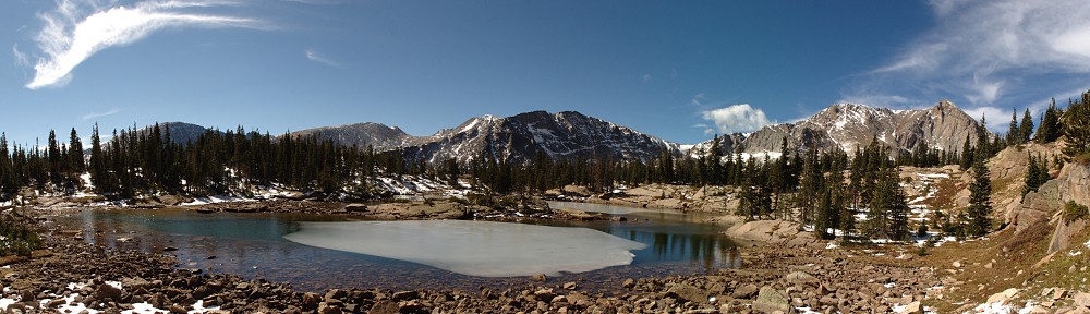
There were already several people at the lake when I got there, including some campers whose tent showed up in almost all my pictures. Being that it was only nine, and I was thinking I wanted to eat my lunch here, I had quite a bit of time to enjoy my surroundings. I started by heading to the north shore of the lake, and from there up the slope a bit. I found a spot on the edge of a talus field with a rivulet of water gurgling down the slope through grass and bluebells.
I considered circumnavigating the lake from here, continuing counter-clockwise. I very nearly did it, but I decided later it would have taken longer than I originally thought. There’s a large clump of willow that would have to be avoided, and that would take the hiker quite a bit downslope from the lake. Here you would regain the trail to the lake. The trail officially ends at the lake but is visible for quite a ways. It may take hikers to the summit of Citadel Peak, but I can’t be sure.
One thing to keep in mind about these alpine lakes is that although they have only one outlet, there are almost always more than one inlet. In the case of Herman Lake, I might describe it as having no inlet. Water flows into the lake from almost all sides. In my photos, anywhere you see clumps of willow there is water flowing into the lake. Inflows are ubiquitous.
My second resting spot was on the eastern shore of the lake. I sat there for a while watching a small bird hopping along the ground, hunting insects. In the twenty minutes or so that I watched, he made a thorough search of an area about half the size of my backyard, occasionally stopping to sing me a little song.
While I sat there, perhaps another thirty people reached the lake. One chap found a place on the shore to collapse and loudly exclaimed, “The torture was worth it!” I’m sorry, buddy. If you felt this two-hour hike was torture, perhaps hiking isn’t for you!
There were perhaps a dozen dogs as well, many of them unleashed. (Dogs are permitted, but are supposed to be on a leash.) During my stay at the lake, I heard the chirps and barks of chipmunks, ground squirrels, and marmots, but I never actually saw any. I’m guessing the dogs kept the little critters stressed and out of sight. I’ve read many reports that say this area is good for spotting moose, elk, and bighorn sheep, but I saw no large game all day.
After scouting the lake’s outlet and southern shore, I found a third location and had my lunch. This spot was near where the trail reached the lake and I could get a good sense of how many people were coming and going. Assuming room for about a hundred cars at the trailhead, that would mean about two hundred people at the lake or on the trail. And with early hikers leaving their parking spots, even more people could make the trip.


Even though it wasn’t yet 11 am, I decided it was time for lunch, which included a Sippin’ Tropical Sour beer (mmm!) from Odell. It was after noon somewhere, eh? Fed and watered beered, I started back down the trail. It didn’t take me long to doubt my math. At no time between the lake and the trailhead was I out of sight or earshot of other hikers. This is a really busy trail! Anybody searching for solitude won’t find it here.
I was back to the car a bit after 12:30. It took me a bit less than two hours to make the hike up. I spent nearly two hours exploring the lake, relaxing, and eating. And a bit over an hour and a half for the hike out. Back at the trailhead, a woman told me she thought it was a difficult hike.
I thoroughly enjoyed the hike and understand why it’s so popular.
A few additional photos can be found here.


