I’m a little bit ashamed to admit how much of my life is spent on autopilot. We all have a tendency to let ourselves get stuck in ruts: “I’m doing this because I’ve done this before and I’m used to it.” That sort of thing. I think a good portion of my choices of where to hike has been out of laziness. I continue to hike in Rocky Mountain National Park because I’m comfortable there. It’s close, I know my way around the Park, I have a first-rate guide, and so on. It only takes me an hour and a half or so to get to any east-side trailhead and about two hours for a west-side hike.
I started getting away from the Park when they instituted their timed entry pass system. I climbed out of my rut and looked around. The Indian Peaks Wilderness is close – just south of RMNP. And James Peak is adjacent to IPW. Again, trailheads for IPW and JPW are close and can be reached in about an hour and a half.
Climbing further from my rut, I finally realized just how many hiking trails I can reach in no more time than it takes to reach a west side trailhead in RMNP.
One of those trailheads is the Willowbrook trailhead in a residential area of Silverthorne. This trailhead can be used to reach Salmon Lake and Willow Lakes, in southeastern Eagles Nest Wilderness. These lakes are surrounded by the dramatic cliffs of a number of 13ers: Rain Peak, East Thorn, and Red Peak.
I don’t have a good guidebook for this area, so I’m doing my research online. I’ve been around the internet long enough to know that not everything I read there is true. I don’t generally think this is much of an issue when it comes to researching hikes, but it’s a good thing to keep in mind. For example, two resources I commonly use are AllTrails and ProTrails (those links go to their respective Salmon Lake route descriptions). AllTrails says it’s a 9.8-mile round trip to Salmon Lake but ProTrails says it’s 15.3. ProTrails would have us start at a different trailhead. I use CalTopo maps and the distances given there match AllTrails.
A couple of notes before we start. First, the parking lot here holds only about a dozen cars but there is a shuttle available. Arrive early or find the shuttle. Second, there is a large network of trails in the area and there is a series of trail junctions. For hikes where I’m not going off-trail, I don’t always carry a map. Bring a map for this one.
Thursday, August 17
I arrived at the trailhead a bit before 7:30. There were only a few cars in the parking lot, and I’m guessing those belong to backpackers who spent the night at one of the lakes. CalTopo shows trails starting at two points near the parking lot, perhaps a hundred feet apart. This is incorrect. There is only one trail from here. There’s a place to register for overnight stays in the Wilderness. There is no fee, and no registration is required for day hikes.
The trail starts in a residential area and passes through Summit County open space before reaching the Eagles Nest boundary about three-quarters of a mile. CalTopo shows four trail junctions before the boundary, but there are only two. The forest is sparse enough to allow views of Silverthorne and Dillon Reservoir and dam. Alongside the lower sections of trail, beetle-kill trees are stacked in pyramids ready for burning when there’s snow on the ground.
Shortly after entering the Wilderness, the trail meets the Gore Range Trail. For the next mile and a half, the trail passes through an interesting section of forest. At first, it reminded me of the area around Ouzel Falls about ten or fifteen years after the fire. All the big trees were dead, the living trees are no more than ten or twelve feet tall. With no big trees, the views open up.
Here, there are no signs of fire in the last century. Hiking up the trail I didn’t notice it, but on the way down you can see that all the dead trees are lined up in the same direction. Why are all the dead trees lined up so nicely?
This area was greatly affected by beetle kill quite a while ago. It was one of the first places I recall seeing beetle-kill forest. The beetles burrow into mature trees, all with trunks at least ten inches in diameter. So all the big trees die, but beetle-kill trees take a while to fall over. They go from reddish-brown to gray and finally get knocked over randomly by wind or snow over the years. And they’d fall over in all sorts of directions.
I think this area was hit by a microburst. Two or three or four minutes of very high winds. Even live trees can’t stand up to the force; this dead forest never had a chance. Any creature unfortunate to be in the area was unlikely to survive. The dead trees are so densely packed, that getting through this area without a trail would be impossible. You just can’t bushwhack through it, you’d have to detour. Truly impassable without a trail.
Because the deadfall was so dense, I couldn’t see too many stumps. But I don’t think there were as many stumps as trees. Most of the trunks looked to be snapped off at the roots.
The next trail junction is the Willow Lake trail. Here the trail starts climbing steadily and relentlessly. It’s not terribly steep, but it goes on and on at a constant rate. On the way down, even knowing how long it went on, I was surprised at how long it went on. Above the top of this grade, though, the trail mellows considerably, climbing no more than two hundred feet a mile (with one exception).
After the big climb, the trail traverses a steep valley wall and reaches the final trail junction of the hike: the Salmon Lake trail. My plan is to visit both Salmon Lake and Upper Willow Lake (and lay eyes on the other various Willow Lakes). By my reckoning, it’s 5.8 miles to Upper Willow Lake with a one-mile round-trip side trip to Salmon for a total of 12.6 miles and maybe 2,800 vertical feet.
I would do Upper Willow Lake first, and if I didn’t feel like doing Salmon it would be a good excuse to come back. Alternatively, it would make a good single-night backpacking trip.
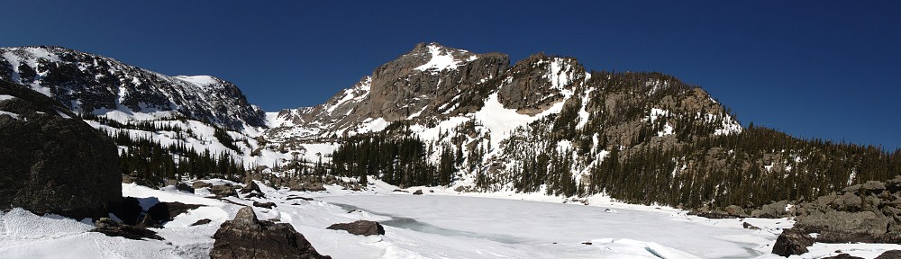
Continuing toward Upper Willow Lake after the Salmon junction, the forest thins again, revealing the dramatic faces of the mountains and ridges containing the valley: the flank of Red Peak to the south, Capricorn, Gemini Twins, and Sagittarius to the west, and East Thorn to the north. The trail meanders along a stream and among and along four or five lakes and ponds before reaching its final destination.
I stayed at the upper lake for forty-five minutes. I had my picnic lunch first. Instead, I should have taken a bunch of pictures first. By the time I was done eating, the few puffy clouds of earlier had grown big and gray. So it goes. After lunch, I explored for a few minutes before heading back down.
Back at the junction, still feeling fresh, I headed up to Salmon Lake. This is the exception to the generally mellow nature of the trail above the big climb. Here we are on a section reminiscent of the big climb. It is mercifully shorter, but at first seems almost malicious: we have climbed a hundred feet or more above Salmon Lake.


Salmon Lake, I think, is not as scenic as Upper Willow Lake. True, that’s not a low bar. The trail skirts north of the lake, avoiding a giant boulder field, dumping the hiker at the willow-choked western end. Half, or more, of the shore is talus.
By counting the number of hikers I encountered all day, I doubt the parking lot ever filled up. There were only two cars there in addition to mine when I got back to the trailhead. I didn’t meet more than a dozen hikers and backpackers.
On the hike out, I got sprinkled on a bit, just enough for me to put the raincoat on. There was a thunderstorm across the valley to the east, the thunder distinct but not nearby. I got a big dose of the solitude I enjoy. Not a bad way to spend the day.
Due to the generally sparse forest for much of the hike, the views are above average. There’s only one section of trail I found difficult. It’s certainly worthy of a return visit.
Timetable
Not an out-and-back, this hike was a Y. The stem is the base of the Y.
| Hike In | Hike Out | |
|---|---|---|
| Stem | ||
| Trailhead | 7:32 am | 4:54 pm |
| North Willow Creek jct | 7:50 am | 4:36 pm |
| Three Peaks jct | 8:06 am | 4:18 pm |
| ENW Boundary | 8:09 am | 4:15 pm |
| Gore Range jct | 8:16 am | 4:06 pm |
| Maryland Creek jct | 9:08 am | 3:03 pm |
| Salmon Lake jct | 10:13 am | 2:02 pm |
| Upper Willow Lake | ||
| Salmon Lake jct | 10:13 am | 12:55 pm |
| Upper Willow Lake | 11:13 am | 11:59 am |
| Salmon Lake | ||
| Salmon Lake jct | 12:55 pm | 2:02 pm |
| Salmon Lake | 1:15 pm | 1:45 pm |
Dave: I am really enjoying your hiking blogs. The scenery is stunning, and your essays are well-written. Thanks!