It’s officially unnamed, but if I don’t apply names to some of the officially unnamed bodies of water I visit in the Park I’ll confuse myself. In the past I’ve resorted to calling them things like “unnamed lake at 11,200′ on Hunter’s Creek”. That’s a bit cumbersome and I don’t really want to continue very far down that road.
But I’m not certain how to name this one. Is it Ptarmigan Tarn, or would Fern Tarn be better? It sits beneath the snow field at Ptarmigan Point, but it’s at the source of Fern Creek. Do you name the tarn after the glacier or the stream? Is it a glacier, or just a snow field? Is it a tarn if a stream flows from it? Too many questions. I’m going with Ptarmigan Tarn.
Sunday, August 25
It’s a fairly short hike, just a bit over three and a half miles, and about fourteen hundred feet in elevation gain. That meant we didn’t have to get too early of a start. I had Chad meet me at my place at 6:30, and we stopped for a quick bite of breakfast as we passed through Boulder. Historically I haven’t been too concerned about getting a parking spot at the Park and Ride, but this summer I’ve seen the lot there get quite full, so I did have a bit of low-grade anxiety about getting to park there after 8:00. The anxiety was not founded, as the lot was back to what I’m accustomed to there: it was only about a third or less full, and there was no line waiting for the bus.
We hit the trail at Bear Lake at 8:36 and spent most of our time on the trail discussing the relative merits of various Sci-Fi television series. I usually make a note of the time when I reach various navigation points, which in this case would be the junction with the Flattop Mtn trail and upon reaching Lake Helene, but we were in the depths of plot line analysis of various Star Trek and Farscape episodes, and how many demerit points Farscape deserves for ripping off a Gilligan’s Island episode. So I didn’t note the time until we reached our destination, not quite two hours after leaving Bear Lake.
I have somehow never noticed that there’s a fairly well-developed trail leading up the hill around the west west side of Lake Helene. I’ve never gone any farther up the canyon than some large rocks overlooking the lake, and I always went around the east side of the lake to reach them.

This trail served us well on the way up. It was covered for a few yards by a bit of snow, and there really aren’t many cairns marking the way, but it was fairly obvious which way to go. I did note one place where I thought might be easy to make a wrong turn on the way down. But overall it was easy route finding and we avoided what little willow and krummholz we saw.
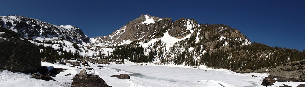
My map shows one body of water up here, but in reality there are two. In spite of a forecast high in the upper 90’s for Denver, it was quite cool here at nearly 11,000′. And to say there was a stiff breeze would be a bit of an understatement. Unable to find a spot that was both out of the wind and in the sun, the best we could get was the leeward, shady side of a large boulder beside the easternmost, smaller lake. And “leeward” isn’t quite right, either, as the wind swirled around our rock chaotically. Within a few minutes we had both donned our jackets to keep warm.

I set the GoPro up where I thought it least likely to get moved by the wind and placed a rock behind it as ballast. We had our early lunch, well before eleven, and watched the wind whip whitecaps on the water. And twice while we sat there, the wind blew my hat off sending us scurrying to grab it before it could start a trip to Kansas.
After our blustery break we headed back down. And, of course, we managed to make one wrong turn on the way down but it wasn’t difficult to get back to the route we took on the way up. As it was still early, I considered taking another pause on the shores of Lake Helene but it was still fairly windy here and neither of us particularly wanted to deal with it, so we headed back down the trail and into the trees.

Very quickly we encountered two twenty-something women. They asked us if we could point them to Lake Helene. It turns out they were headed to Ptarmigan Tarn as well, and that’s the name they used for it. I donated my map to them and we gave them a couple of route finding tips and a warning about the wind.
Approaching the junction with the Bierstadt trail I considered the option of walking back to the Park and Ride, but Chad had just run out of water. So I’ll save that option for another time. We made it back to Bear Lake by 1:15. After a stop for food and beer we headed back home. The thermometer in Chad’s car read 101 as we passed through Boulder, and our chilly, breezy picnic was just a fond memory.