
East Inlet is a stream that flows roughly ten miles from the northern flank of Isolation Peak to the eastern shores of Grand Lake. There are five lakes along this stream, like beads on a string: Lone Pine Lake, Lake Verna, Spirit Lake, Fourth Lake, and Fifth Lake. They ran out of names.
I tried to get to Fifth Lake back in 2009. That was the first year that I kept a log of my hikes, but before I was blogging. I attempted it as a day hike, hitting the trail at 7:30 and reaching Fourth Lake at noon. As that was my “bingo” time, I stopped there, ate my picnic, then headed back. I returned to the car a bit before 5:00. Given that it might take about an hour to get to Fifth Lake from Fourth Lake, I figured it was out of range for me for a day hike.
If I can’t do it in one day, perhaps I should try it in two. So when March 1 rolled around I went online to make a reservation for one night at the Lake Verna campsite. I didn’t get my request but when I visited the back country office to make my reservation for zone camping for my Gorge Lakes hike, I managed to negotiate a good alternative. The Lake Verna campsite was booked up on all the dates I was interested in, but Upper East Inlet was available for September first. It’s just a couple tenths of a mile below Lake Verna so there’s no real functional difference.
The plan was to hike in to the campsite on day one, rise early on day two to get up to Fifth Lake and back to the campsite around noon, then hike back to the car. When I made the reservation, I didn’t have anybody lined up to accompany me but I booked it for two people anyway. About a week ago Gordon volunteered to go.
Saturday, September 1
Because we essentially had all day to get to Lake Verna we made a leisurely start, putting boots on the trail at about 10:00am.
It has been nine years since I hiked this trail but I have a few very distinct memories of it. I remember encountering a bull moose just below Lake Verna with a lame left front leg. I remember it being on a section of trail that traversed a rather steep treeless slope. There is no such section of trail. I’m the first to admit my memory isn’t the best, but in this case it’s a pretty disappointing mismatch. As to the rest of the trail, only a couple of short sections of that hike stayed with me. So in a sense, much of it was somewhat like being on a trail I’d never hiked before.
On that hike long ago, I found a moose in the marshy meadow quite near the trailhead. Today we found two moose even closer to the start. They were quite near the trail. Almost too close for comfort when I realized it was a cow and yearling calf. I probably have that nomenclature wrong. It was a young moose, but now nearly fully grown. I know moose can be unpredictable and wouldn’t want to get between mother and calf.
 These two were quite calm, probably used to being in the presence of people. The only other time I’ve been this close to a moose was that earlier encounter on this trail with the lame one. We quietly watched them for a few minutes and took a few pictures. As they slowly worked their way into the trees and away from the trail, the cow let out an odd little moan, then pooped. I realized I’ve never knowingly seen moose poo before. Last year I learned that much of what I’ve taken for years to be deer poo is actually llama poo. This year I learned that moose poo looks a lot like horse poo.
Lone Pine Lake is the first lake in the chain, 5.3 miles and 1500 vertical feet from the trailhead. The first two miles or so follow the stream as it meanders through a broad marshy valley and gains only about a hundred feet. After that easy first two miles, the trail climbs about 1400 feet in just over three miles. This section of trail goes through some fairly rugged country, and the trail between here and just above Lone Pine Lake is what I’d call “highly engineered”. There are a number of stretches where you climb rather a long series of stone stairs.
When we got to the campsite it seemed to me like we’d climbed a thousand of these stairs. That’s a ridiculous number, obviously. When we got to the first of these on the way down I asked Gordon how many he thought there were. “I don’t know. 232?” I said it seemed like a thousand, even though that was an exaggeration. I said that I didn’t intend to count them, but then went ahead and counted anyway. I lost track a couple of times, but by the time we got back to the car I’d counted 725. The actual number is probably between 700 and 750. Those are just the obviously engineered stairs and doesn’t include the many rocks that naturally lie on the trail or are set to divert rain water off the trail.
In addition to the many stairs, there are long lengths of trail that lie on top of carefully built stone walls. There are also some spots where the trail was laid on a ledge that was carved out of large rock outcroppings. Some serious work went into constructing this trail. I really appreciate it, as when looking at the terrain from below it doesn’t look like the kind of country I would be willing to cross without a trail.
I don’t know the fire history of this area. None of it has burned since 2000, but there’s a pretty good section that looks to me as if it has recently burned. There aren’t any large swaths of dead trees, but the tree trunks for quite a stretch of trail look like they’ve seen some fire. There’s one stretch of stone stairs that I recall quite well from before and through here it seemed to me that there were quite a few more downed trees now than then.
We stopped for a rest perhaps half way up the climb to Lone Pine Lake. That’s not half the trail distance, but half the climb, so maybe three and a half miles in. To that point I thought we were making pretty good time. But carrying the pack was starting to wear me out. We took another break at Lone Pine Lake. I really struggled to get there, as I wanted to stop about half an hour earlier. But Gordon took the lead for a while and convinced me to continue until we arrived at the lake.

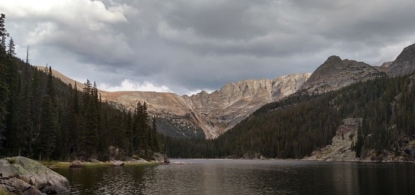
Lone Pine Lake
It was nearly 2:00 when we got to the lake, and we paused for about fifteen minutes. The weather forecast for the area called for a 60% chance of rain in the afternoon, with some snow possible overnight (with “little to no accumulation of snow”). The skies by now were clearly threatening, with the occasional rumble of thunder. So we didn’t delay too long.
It’s just over a mile and a half from Lone Pine Lake to Lake Verna, and our campsite is a couple tenths below Verna, so we didn’t have much farther to go. Verna, Spirit, and Fourth lakes lie in a valley that hangs above Lone Pine. There’s not much elevation between those three lakes, but the trail climbs a bit over two hundred feet in the next half mile or so. This is another highly engineered stretch of trail that includes a few bridges and a rather large retaining wall. The trail tops out on a rock outcropping with a nice view of Lone Pine Lake.

Above Lone Pine Lake
From here to the campsite it’s pretty easy walking; a nearly straight line for about two thirds of a mile. The campsite itself is a few yards north of the trail, up another thirty or forty feet. It looks like a number of rather large dead trees have recently toppled, their thin disks of soil and roots standing upright. The large trees were dead, but in toppling they took with them some young, live trees. These were still green, so they haven’t been down for very long. I’m sure that if anybody was in the campsite when the trees came down it was quite thrilling.

Upper East Inlet campsite
After we set up camp we headed to Lake Verna. On last month’s trip, I carried two full bottles of water. This time I carried both bottles but only one was full. I figured we’d never be far from a water source so I didn’t need to carry the extra weight, but at camp I’d probably want to have more than one bottle of water, given I’d use something like half a bottle to cook my meal. After I filled my bottle, we sat there and watched the world go by for a little while.
Lake Verna, early evening
Back in camp Gordon surprised me by pulling a couple cans of beer out of his pack: Left Hand Brewing Traveling Light Kolsch. Much the way that I find a peach always seems to taste best when on the shores of an alpine lake, I was quite satisfied with this tasty little Kolsch, even though it was warm.
By sunset the clouds had cleared and by the time I turned in, the first stars in the night sky were shining brightly above us. Had I tried to stay up long enough, I might have seen a little sliver of the Milky Way as the moon wouldn’t rise for a few hours yet. I was happy that the 60% chance of rain hadn’t materialized, other than a few sprinkles when we sat at Lake Verna. With no clouds overhead at sunset, I was confident we wouldn’t get rain (or snow!) overnight.