Iceberg Lakes

I told Gordon, “Let’s camp at Clayton Lake for a couple of nights and go to Iceberg Lakes. Nobody goes there; we’ll have the place to ourselves. I know a game trail that will take us there with ease. We don’t need a permit, so we can go any time. Pick a date.”

I’m afraid I gave him some misinformation.

I’m always paranoid about parking at the trailhead. We were early enough on a weekday to have no problems, but when we got back to the car on Sunday, a bit after noon, cars were parked for a quarter of a mile down the side of the road.

On the back of my map I had scribbled a note: “about 300 yards past coil of cable, take the game trail to the left, next to a sawn tree trunk.” I probably mentioned the coil to Gordon three or four times. I had a chat with a hiker going the other way and asked her if she saw the coil. She said she had on the way up but not on the way down. The trail had been worked on in a few places and I was wondering if maybe they’d taken the cable away.

All of a sudden, we arrive at Crater Lakes. I never saw the coil. Without the coil as a landmark, it’s a tough ask to pick the right downed tree trunk. So much for finding my nice game trail. Not a big deal, though, as it’s pretty easy navigation. Unfortunately, we never did find a game trail, which surprised and disappointed me.

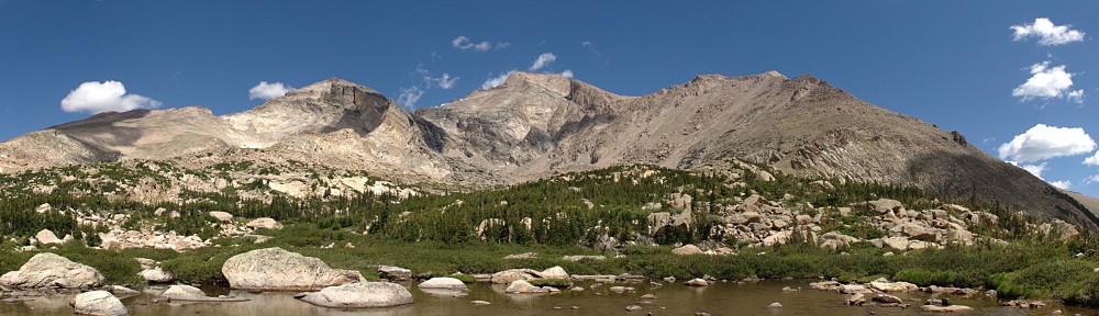
We arrived at Clayton Lake a few minutes after one. We take the obvious best campsite, at the edge of a large meadow atop a short slope above the lake. Two hours later, two guys show up. There aren’t many places to camp; they ended on a shelf above the other side of the lake.

So much for having the place to ourselves. The next day, another two backpackers showed up and a handful of day trippers visited. The first two backpackers asked, “Are you fishing, or doing anything else exciting?” Different strokes, but I never considered fishing “exciting.” When we told the other backpackers we’d been to Iceberg Lakes, they asked if we fished up there.

After sitting beside Clayton Lake for several quality hours, it’s obvious why people like to fish there: the lake is loaded with fish. So many were rising, there were so many ripples, it looked like it was sprinkling. The fish are pretty well camouflaged, but if there’s no glare on the water, they’re easy to spot. Every one I saw was between six and eight inches long.

Friday night, I discovered that I had a bit of a technical issue. I carry a small battery pack on these hikes so I can charge the phone or the action camera. It’ll even charge my new Steripen. Unfortunately, it wasn’t charging my new phone. Gordon had a battery pack, too, but my phone didn’t like it, either.

The problem is, I haven’t figured out how to use the Insta360 without using the phone. And it puts a surprising load on the phone’s battery. I’d been doing some filming during the afternoon, and, well, the phone battery situation wasn’t good. I’d have to keep the phone turned off except when I was working the Insta.

Saturday, we hiked up to Iceberg Lakes. Clayton is at about 11,000′; Iceberg Lakes are about 700′ higher, just 300′ below the Continental Divide. Reading the map, it looked like it might be possible to climb alongside the outlet of the southern lake. In actuality, that doesn’t look like a very fun route. Instead, we climbed some grassy ramps up the right side and gained the northern lake from the northeast.

It was a fun little climb. We avoided willow and Krumholtz almost entirely and only had to cross a couple of small talus fields. We passed a shelf that the map shows holding one pond; today there were three. About here we encountered Bullwinkle the Moose. He was a big boy, and he was on a mission to visit those three ponds. We were pretty much in his way, but he didn’t care. I kept a small cluster of stunted trees between us as he passed.

The northern Iceberg Lake is sort of gourd-shaped. The smaller, northern part of the gourd is covered with slabs of ice, free-floating – not connected to the shore. The southern lake is nearly round, and about two-thirds ice-bound. Even at the edges, the ice is thick enough to carry a couple of pretty large rocks that had fallen onto the lake over the winter. There’s still a bank of snow on top of the ice. Sapphire pools of water dot the area.

I passed the time relaxing on the saddle above both lakes. Gordon explored, as he usually does. From the saddle, you can see hikers on the Continental Divide Trail. When I first saw them, I thought they were crossing over from Crater Lakes. It’s a busier trail than I’d have imagined; I saw nine hikers in an hour or so.

As can be expected along the Continental Divide, it was on the windy side. After some time at the southern lake and on the saddle between, we looked for a spot out of the wind at the northern lake. We found little relief.

On the hike out, we managed to retrace our footsteps almost exactly, but we did not see Bullwinkle.

Late that afternoon, we were sitting in our camp. Here I should mention that I bought a camp chair. It folds down pretty compactly and weighs only a pound, four ounces. Or is it 1.4 pounds? In any event, I enjoyed relaxing in a chair. We were shooting the shit when we heard a loud splash in the lake. Our friend Bullwinkle walked across the western end of the lake to get to the south shore. He climbed up to where we think the first backpackers were camped the previous night.

Sunday morning, we considered whether we wanted to go out the way we came in, or follow the old trail down the outlet stream that everybody else uses. We stuck with our route. Unfortunately, we traversed around the slope without descending enough, and before long, we were on a ridge about 250′ above Crater Lakes. We backtracked a bit to find a place to descend. It was only near the bottom of our descent when we came across a nice game trail. It was the one I followed out last time, the one I missed on the way in..

Reaching the trail, the first person we met was a volunteer ranger. He quizzed us on our bear etiquette and made some notes in a little memo pad. I wanted to ask, Bugs Bunny style, whatcha writing, doc? I wanted to ask, Dad joke style, if this was going on our permanent record. I behaved.

It was a nice trip. Even if it was more crowded than expected, even if we missed the game trail. Clayton Lake is unspectacular, but I’m jaded. It’s a great place to fish, but bring the heavy-duty bug spray, because it’s a mosquito-rich environment.

Clayton Lake

Imagine your left hand, palm up. The hikes in the James Peak Wilderness correspond roughly to your fingers: Rogers Pass Lake and Heart Lake would be on your thumb and Lower and Upper Forest Lakes your pinky. Clayton Lake, then, as well as the two Iceberg Lakes, would correspond to your index finger.

Back before James Peak Wilderness became part of the National Wilderness Preservation System in 2002, there were trails serving the lakes on each of your fingers. The trail to Clayton Lake, though, was “abandoned” about thirty years ago. (The trail to Arapaho Lakes was similarly abandoned a bit more recently.) According to various online resources, though, the trail still gets quite a bit of use. All these sources say the same thing: just follow the creek straight up the hill. Descriptions of this former trail are all very similar: “The creek and trail funnel through a rock-bound gulch with little room to maneuver.” “That last part was pretty hard but really cool.” “There is a section that is a bit of a steep scramble. Used my hands quite a bit through that section.” And there’s this one: “I read all the comments and they said ‘It’s hard to see the trail as it’s not maintained.’ No, the trail just completely doesn’t exist at all. I attempted and got completely lost. It was quite scary and will never do it again.”

A couple of summers ago, I ran into a volunteer and quizzed him about reaching Clayton Lake. He suggested that it’s easier to get there by going up the Crater Lakes trail to about 9400′ or 9500′ elevation, then striking cross-country from there. On my hike to Crater Lakes a bit after that discussion had me thinking I knew where I should leave the trail. But it’s an inexact science. Satellite photos aren’t much help, as the area is fairly thick forest. But it does seem that this route avoids climbing straight up a steep slope. I was willing to give it a shot.

Ideally, I’d like to reach the two Iceberg Lakes as well, but I’m not confident I can do all three on a day hike. If I can’t collect the Icebergs in a day hike, I’ll need to backpack in and spend a night. I’m not confident that the “straight up the stream” route, including “steep scrambles” is something I want to try with a full pack. Perhaps the volunteer’s route is better suited. Well, there’s one way to find out.

Monday, July 10

I arrived at the trailhead parking lot at about 8 am. The road is in good shape right now and is set to improve as it is currently being graded. It’s about eleven miles of dirt road to reach the parking lot, but anything short of a low-slung sports car should have no trouble navigating it. I was a bit surprised to see only about a dozen cars in the lot, maybe half of which belong to backpackers not yet back from their destinations.

At the trailhead, there used to be a sign-in sheet where all hikers were expected to list the date, number in the group, their destination, and how long they’d be on the trail. This logbook is no longer there; at least it wasn’t there today.

It took me an hour and ten minutes to reach the trail to Crater Lakes. I hiked up this trail for about forty-five minutes, periodically checking the elevation with my phone. I was at more or less the correct elevation, I figured, so off the trail I went. Going was fairly easy at first, not too much deadfall and the terrain I was crossing was fairly level.

My plan was to avoid making any steep climbs, heading west or southwest and climbing as I went. Before long, I came across a small stream. I wasn’t expecting to reach water until I got to the stream that is the outlet from Clayton Lake, but it didn’t seem like this stream (actually three or four small streams braiding their way down the slope) carried enough water to be Clayton’s outlet. Nonetheless, I headed uphill following the stream.

The forest here was getting more difficult to traverse, getting steeper and having more fallen trees. I crossed the stream half a dozen times as I climbed, always searching for the easiest route. At one point, I climbed a bit where I knew I’d have difficulty going down. I try to avoid going up slopes I think will cause me difficulty when going down, but I figured (if I managed to retrace my steps) that I could make a small detour if need be.

After following the stream for a while, I found the source of my little stream. I was standing at the edge of a marshy meadow. Rather than slog my way across it, risking wet feet, I skirted the meadow. On the other side of the meadow, I found a grassy ramp, somewhat steep, that climbed alongside giant granite slabs. Above me looked to be the low spot of a saddle. Perhaps I was getting close to the lake.

Topping this slope I found myself back in the woods. With the ground much more level, the walking was easy again. I kept climbing, always looking to find the low spot on the saddle. Continuing west or southwest, I expected to come across the outlet stream eventually. Passing through a small band of trees, I found myself on another grassy slope, walking slightly downhill, and could now see the lake. I had arrived on the northern shore of Clayton Lake.

The lake is mostly surrounded by forest. I’m a big fan of finding a nice rock to sit on for my picnic. Ideally, said rock would be in the sun, out of the wind, and close to the water. In search of such a rock, I worked my way around to the outlet. There’s still quite a bit of snow here and I easily crossed a snowdrift that hid the outlet. I saw no sign of the old trail, but there was a social trail that edged the north shore. Finding mostly snow on the south shore, I abandoned my search in this direction and doubled back.

From the time I left the Crater Lakes trail until I returned to the trail about three hours later, the only sign I saw of any other person was a boot print in the mud on the little social trail that skirted the north shore.

I wandered the north shore for about fifteen minutes before I found my picnic rock, considerably farther from the water than I wanted to be, but so it goes. Just before I got off the Crater Lakes trail, I met a couple of backpackers on their way back to the trailhead. I asked if they’d seen any game. “Just mosquitoes!” Mosquitoes aren’t big game, but even on my picnic rock, out of the trees and in a light breeze, mosquitoes buzzed me constantly. I’d sprayed some mosquito repellent on me back at the car, so I was happy that it seemed to still be working. They buzzed, but they never landed.

After relaxing for a bit more than half an hour, I started to retrace my steps back down the mountain. I’ve found that route finding is easier on the way down than on the way up: the value of the high ground. I quickly found a game trail. A few yards down the trail, I felt that I should have been heading more to my left, but I stayed on this game trail for a bit longer. It seemed to be well-traveled, punctuated as it was with pellets. Before long, I decided to backtrack, forgoing the trail for the untracked ramp I climbed earlier.

Back at the marshy meadow that was the source of the small stream I followed uphill for a while this morning, I managed to find another game trail. At no time on my climb to Clayton Lake did I find a game trail, but from this trail I found just below my marshy meadow all the way back to the Crater Lakes trail, I managed to go from one game trail to another.

My experience with game trails is that they’re nice when they’re nice, but they often stop being nice in the most inconvenient places. Today, every time deadfall blocked the trail, I was able to find its continuance a few yards later. Game trails generally aren’t singular things: they’re all part of a network. From the marshy meadow back to the trail, whenever there was a choice of direction, I kept to the left and downhill. I figured I couldn’t go too far left – I’d eventually reach the Crater Lakes trail. My only concern was not finding myself at the top of some rock outcrop that I couldn’t get down.

These game trails kept me out of trouble: I’m pretty sure the deer and elk aren’t interested in getting stuck on some random outcrop and they don’t want to go up or down anything too steep. As I said, this game trail took me right to the Crater Lakes trail. I made a note of where it is. On the hike up the Crater Lakes trail, there’s a large coil of cable just off the trail. I have no idea why it’s there, but it’s been there for years. I figure my game trail is something like three hundred yards past the cable, very near a large sawn tree trunk. [Edit 07/20/2025: the coil of cable has been removed during recent trail maintenance.]

Given that my route back from Clayton Lake was so easy, I think I’ll return on a backpacking trip. Even having found this easy route, I think Iceberg Lakes are too far for me to reach on a day hike. Hiking cross-country with no trail is a lot more time-consuming and more strenuous. But I’m confident I can backpack up this route and by spending one night at Clayton Lake, I should be able to collect both Iceberg Lakes.

When I’m hiking on a trail, my mind often goes into auto-pilot mode. I just keep putting one foot in front of the other until I get to some navigation point. My feet stay on the trail, but my mind wanders. Bushwacking, though, is another story. My mind is intensely focused on the task at hand. Bushwacking is a bit like solving a maze that has more than one solution. At any given point, I’m looking for where I should go next. How do I get around this jumble of deadfall? I want to go there, but what’s the best way? Once I get there, where do I go next? My mind does not wander. I’m not thinking about some TV show, I don’t have some song earworming into my brain, I’m not bothered by what some idiot said on the internet, and I’m not worrying about rent, or debt, or thinking about what I might do tomorrow. I’m in the here and now, completely focused on the moment. It is glorious.

LocationUpDown
Trailhead8:10 am2:30 pm
Forest Lake jct8:46 am1:57 pm
Crater Lake jct9:20 am1:27 pm
Left trail/returned to trail9:54 am12:43 pm
Clayton Lake11:00 am11:57 am