Haynach Lakes

I had a business trip last week, so this report from last week’s hike is a bit delayed. Sometimes I can crank these things out pretty quickly, sometimes it takes forever. I thought this one was particularly interesting, so it has taken a bit longer.

Saturday, August 10, 2013

This hike has is the longest (most miles) I’ve hiked in a day, but in the end it turned out fairly easy. I knocked it off in less than nine hours, including nearly an hour at the lake and a couple short breaks on the way back to the car. I wanted to put boots on the trail by 7:30 and to be at Haynach by noon. And I wanted to see a moose.

As it’s been on my list for a while; I spent quite a bit of time looking at the maps. I broke it down into four parts. From the trailhead to the junction with the Tonahutu trail. Something like 1.8 miles and a 600′ climb. This puts you over the “divide” between Tonahutu Creek and the Kawuneeche Valley, the source of the Colorado river. Then 3.5 miles to Granite Falls, edging around Big Meadows for quite a ways and only gaining about 400′. Section three is Granite Falls to the junction with the Haynach Spur trail: 2 miles and 600′. Finally, the last mile and a half and another 600′ gain. The Foster guide has the total distance 8.7 miles and 2,260′ of elevation gain. It’s long, but not much of a climb.

I didn’t quite put boots on the trail on my target time, but did reach the Green Mountain trailhead parking lot at almost exactly 7:30. There were a handful of cars in the parking lot, all covered with dew. I backed into the end spot closest to the trail. It’s a two hour drive from home, up I-70 then over Berthoud pass. Very little traffic, as usual. Around Fraser there was ground fog but cloudless skies. By Grand Lake it was soup – I never saw the lake even though it’s within yards of the road in many places. But it was clear again by the park entrance and at the trailhead.

Based on the weather forecast, I thought there was a real chance it might be cool enough to wear jeans but I stuck with the shorts. It was pretty chilly; I had turned the heater on in the car in Winter Park. When I got out of the car I was thinking maybe I should have worn jeans after all. But the trail starts off fairly steep and I was warmed up before long. This part of the trail was very wet, both in the morning and afternoon.

After a steep start you reach the first meadow. There are three or four meadows near the trail with short climbs in between. Then the trail descends slightly to Big Meadows and meets the lower Tonahutu trail. At just after eight, all these meadows were misty. Near the trail junction, two people were out in Big Meadows talking loudly enough, I’m guessing, to be heard a mile away. Big Meadows is something like a half mile wide and three miles long, wider at the north end than the south.

Then I met a couple on their way back to the trailhead. They had intended to camp at Haynach Lake but had difficulty with the altitude so they stayed at the Sunset camp site instead. They were from Kissimmee, FL. He said he bought a new tent for the trip, but neglected to open the package before reaching the camp site. No stakes. I asked if they’d seen any wildlife. Just squirrels.

Big Meadows

The trail goes north here. At first the trail is adjacent to the meadow, providing a nice view of Big Meadows. Somewhere in here I was hoping to see moose. I stopped and looked whenever there was a nice view but no luck. Soon you pass two derelict log structures; I’m sure that even when they were new they were not much more than basic structure. Next the trail climbs a bit to a junction with the Onahu Creek trail. On the first tree past the sign was stapled a notice.

Trail Condition Warning:

Due to a recent wildfire in the upper Tonahutu drainage various travel hazards exist in the next several miles. Use caution and good judgment when crossing the affected area.

POTENTIAL HAZARDS INCLUDE:

  • FALLING TREES
  • SLOPE INSTABILITY AND MUD SLIDES
  • COLLAPSING TRAIL TREAD
  • FLOWING DEBRIS ACROSS TRAILS
  • DIFFICULTY FOLLOWING DESIGNATED TRAILS DUE TO FIRE DAMAGE
  • DAMAGE TO BRIDGES
  • POSSIBLE RE-IGNITION OF FIRE

I had forgotten all about the Big Meadows fire. The fire started in early June. By the 20th it was declared 95% contained. This meant they had established secure fire lines around it. They expected that the fire might still occasionally be seen throughout the summer, until a significant weather event put it out. In the mean time, the upper Tonahutu Trail would remain closed. I later heard from a hiker that this was the first weekend the trail was open.

Big Meadows fire

At the end of Big Meadows the trail takes a right turn. The valley narrows and you can finally hear Tonahutu Creek. Here is where the fire damage starts. It’s a lot different than the kind of damage the Fern Lake trail passes through. On that trail, it’s the opposite side of the valley that’s burned. Here, the trail passes right through the most devastated areas. Only a few blades of grass are growing. Everything is black – the still standing tree trunks, ground roots, the ground, the rocks. Some of the rocks got so hot a burned layer has broken off.

Granite Falls was not burned. It is an aptly named falls, tumbling down large slabs of granite. Easy access to both the top and bottom of the falls. Above the falls is another meadow. After that is the largest and most devastated burn area on the hike. Pretty much the entire forest below Tonahutu Meadow campsite. Today, not a blade of grass grows there. All the burn areas still smell strongly of smoke, but it is strongest here. This is probably the last spot to go out, just a week or two ago.

East of Tonahutu Meadows at first looks to be undamaged. From here all the way to the creek that drains Haynach Lake, fire dripped down the mountain like wax down a burning candle. Untouched forest for twenty or thirty yards, then a narrow strip that is burned. Many trees are burned only on one side. A few may even still be alive. There are a lot of downed trees here, blocking or partially blocking the trail. I doubt any livestock could pass.

Finally I arrive at the spur trail to Haynach. It starts very steeply, climbing almost straight up the slope, now out of earshot of any flowing water. This section is the steepest part of the hike. The climb moderates, and the trail skirts a meadow giving the first real mountain view of the hike. There are some wildflowers, but nothing like last week. The meadows are stair-stepped here like on the first section of the trail, but with bigger climbs in between. And the meadows are larger and provide nice views of the southern buttress of Nakai Peak.

The trail goes through a couple of these meadows, becoming less a trail and more a faint suggestion of where to walk. Just below my destination, I hear a noise like distant thunder but not very loud. And there are no visible clouds. Then I see an elk. She sees me and is gone before I can get a picture, her hooves hitting rock. Perhaps the thunder was her sister or cousin scrambling over some rocks.

The final meadow before the lake is really a series of large puddles, almost like rice paddies. Shallow enough to grow grass, but quite large. They’re even on three levels, terraced. Long blades of grass float in the deeper sections.

Haynach_fragment_crop

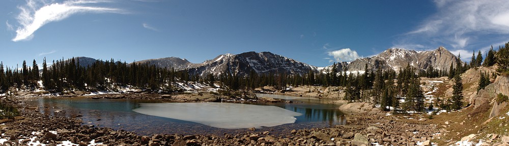
At last I arrive at Haynach Lake. On the map, it looks to me like a hammer-head shark from above, head to the right and in a furious turn, tail fin nearly touching head, with a small dorsal fin between. The trail ends in the grass a few yards from the lake, where the mouth of the shark would be. There is a tumble of large rocks right there, so I set up the camera and dive into my picnic.

While passing through those open meadows I was worried I wouldn’t have many clouds to capture in time lapse, but that wasn’t a problem by the time I arrived at the lake. In fact, the clouds were looking distinctly unfriendly. By the time I took the second bite of my sandwich, graupel started to fall. I could see they were widely dispersed by watching the surface of the lake. Ripples about six feet apart. That didn’t last long, though, and the graupel turned to pea-sized hail and it was coming down fast.

I scrambled to get the SLR out of harm’s way but left the GoPro running. I found refuge among a couple scrawny trees. That, too, didn’t last long. By the time I was done eating it had quit hailing (and never did rain), and some patches of blue sky were visible. I wandered towards the tail fin to get a different view. I thought it was worth the price of admission.

IMG_9818
Scorched earth; rebirth

On the hike back to the car, I had a fruit break at Granite Falls and studied the burned parts in a bit more detail. It looks like there hasn’t been much rain since the fire went out. In a few places, burned material has been washed down the slope like little lava flows. A couple of spots there was enough water flowing to expose unburned ground, badly eroding a few feet of trail. Any sort of moderate rain fall will certainly leave visible scars. And almost all the tree trunks are still standing. I expect 90% of them to fall in the next few years. With dead roots, a fairly stiff breeze will be all it takes. Fire is an integral element of the forest ecology. Lodgepole pine cones often need exposure to extreme heat to release their seeds. But seeing the forest like this, it’s hard to think of it as part of a process of renewal.

There were quite a few more hikers on the lower section of the trail. I didn’t meet anybody for the better part of four hours – between Granite Falls on the way up and a bit below the Haynach spur on the way down – but from Granite Falls to the car I came across dozens.

Approaching the car, I evaluated the day. I’d missed my target starting time but still made it to the lake before noon. Even spending nearly an hour at the lake, I’d be back to the car before 4:30. And I had the unexpected experience of walking through a freshly burned forest. I saw an elk but I didn’t see any moose.

Spot the Moose

Then, not more than twenty feet from my car there’s a moose. The guy hiking in front of me had stopped and was signaling me to be quiet. It took me a few seconds to spot the moose. At first I thought it was a cow but it was a young bull with small antlers. I hike 17.4 miles hoping to see a moose and when I see him, a family piles out of a minivan and takes pictures of him.

Over Trail Ridge Road, traffic not as bad as last time, but still lots of people who disregard all signage. Do not stop on roadway. Use pullouts. Ooh! There’s an elk! Stop the car right in the middle of the road and get a picture! Pullout, shmullout.

I’d have gone home the way I came, but I’m out of beer so I decided to pick up a case at the Estes Park Brewery. Six o’clock by the time I get there, so I call Genae and tell her I’ll eat here. Fish and chips. Traffic not so bad to Lyons, but they had to stop cars to clear a motorcycle from the road. The flatbed arrived just a few cars ahead of me so we got waved by while they were positioning the truck.

A long day, but well worth it.

Timetable

 UpDown
Trailhead (8,800′)07:40 AM04:20 PM
Tonahutu trail jct08:20 AM03:45 PM
Granite Falls (9,800′)09:40 AM02:20 PM
Haynach spur trail10:45 AM01:20 PM
Haynach Lake (11,060′)11:45 AM12:35 PM

Pipit Lake

Sunday, August 4

Within days of my failure to reach Lake of the Clouds, I decided that Pipit Lake would the be the next destination. I was all set to go on July 28 but the weather was bad so I delayed the hike for a week. Then on Saturday night I consulted the maps again and thought perhaps I’d hike to Junco Lake instead. Both Junco and Pipit require reaching Bluebird Lake first, both are the same distance, and Junco is at a slightly higher elevation. At one point I thought I’d make my decision only when I reached Bluebird, but as I’m hiking alone I thought it was better if I had a definite route planned before leaving the house. Always let people know where you’re going.

Before going to bed I decided to stick with the original plan – Pipit it was. I’ll save Junco Lake for next summer.

On my last hike, I walked alongside the Grand Ditch, a water diversion project started a century ago and still in operation. Bluebird Lake features in the history of water projects in Wild Basin, too. Back in 1915 the Arbuckle Reservoir Company received approval from the state engineer to build a dam at Bluebird Lake (Arbuckle Reservoir #2). I’m having a hard time imagining the effort required to get tools and materials to the lake. Bars of steel reinforcement were chained in bundles to an axle beam connecting two wagon wheels, with the end dragging along the ground behind a team of four horses. Sacks of cement were carried by donkeys, as were the parts of the disassembled rock crusher and the car engine used to run it.

Today, the trail between Ouzel Lake and Bluebird Lake hardly looks like a pack trail. While most pack trails in the park are quite wide and much improved, this section of trail is narrow and rocky with relatively few obvious improvements. In places, it’s packed dirt a few inches wide running through waist high grasses. The last section of trail is quite steep, switching back and forth. But I’ve gotten ahead of myself.

I hit the trail a bit before eight on another brilliant, nearly cloudless morning. Based on the cool temps when I left the house, I was expecting it to be a bit brisk at first but was pleasantly surprised it was quite nice – warm and calm. The first few miles of this trail can be quite crowded; the sandals and no water crowd visiting Copeland Falls, those with a bottle of water making it to Calypso Cascades or Ouzel Falls.

Not long after Ouzel Falls, the Thunder Lake trail meets the Bluebird Lake trail. I stopped here for a few minutes to apply sunscreen. After the junction, the trail climbs to the top of a ridge that was burned back in 1978. Lower on the trail, before Ouzel Falls, the forest almost seems back to its pre-fire condition when you’re hiking through it, but from above the fire’s path is still clear. Here on top of the ridge, the forest has made little progress and the views of the surrounding mountains are still clear and dramatic. While the views are fantastic, it means the hiker is left exposed to the sun and wind for an extended time. It was too early to be hot yet, but I was expecting it to be a bit on the warm side on my way down.

Here I chatted with a couple who had spent the night at Ouzel Lake. He said he’d heard moose were in the area but he didn’t see any. “If there were moose here, they’d have been around the lake where there’s lots of vegetation for them. There are no moose here.”

Spot the Hikers

I was dreading, a bit, the section of trail between the Ouzel junction and Bluebird Lake. The trail climbs quite steeply, gaining about a thousand feet in less than two miles. As soon as the trail reenters the forest, there’s a large field of debris left by an avalanche that roared through the trees a few years ago. I stopped here to snack on some fruit but was hounded by mosquitoes so I didn’t dally long.

After a short forest section the trail passes through a series of meadows and rock piles. The meadows are a riot of wildflowers – red and yellow, blue and purple, white. When I say I hiked through mile after mile of wildflowers I’m not being hyperbolic. The last mile or so of the trail to Bluebird, plus the mile from there to Pipit were through these fantastic fields of flowers.

I reached Bluebird in good time. There were six or eight other hikers here, perched on rocks here and there near where the trail ends at the outlet stream. I made my way down into the little chasm the outlet stream passes through; crossed it on some rocks and made my way up the other side. This is where the dam was. There’s no sign of it; a testament to the skill of the rangers who cleared it out. Lisa Foster notes the obvious “bathtub ring” around the lake as indication it used to be dammed up, but I think nature has done a good job of erasing it.

Bluebird Lake and Mt. Copeland

Now on the north side of the lake, I gained elevation slowly as I worked my way west. I wanted to be above a large rock outcropping on the west side of the lake. There is no trail here. I occasionally found a faint path, but the route traverses a lot of talus and I saw few cairns. I made my way up a gully above the rock outcropping and ran into a wall of willow. I immediately flashed back to my hike to Keplinger. But here I was back in the clear after only a few feet and a few minutes later found myself at the edge of Lark Pond.

It occurs to me how many lakes in the area are named after birds: Finch Lake, Bluebird Lake, Lark Pond, Chickadee Pond, Falcon Lake. Those are the obvious ones. Pipit, Junco, and Ouzel are also birds. A few miles away, as the ptarmigan flies, is Ptarmigan Lake. How many more lakes here are named for birds?

Lark Pond

From Lark Pond it’s only a few more minutes and a few more feet of elevation to reach Pipit Lake. I was going to say “walk across the tundra and rocks”, but it’s not really tundra here, is it? I don’t generally think of wildflowers when I think tundra. Although the flowers aren’t as dense here as lower on the trail, they’re still quite abundant. I made a point to walk on rocks where I could. Not just to avoid stepping on the flowers, but the ground is marshy in places as well. It looked to me like water was flowing in braids through this area only a few days ago.

Reaching Pipit Lake, I set up the cameras and tucked into my lunch. There’s no shade here, and no shelter from the wind. But it was fairly calm, so not a problem. After only a few bites I was wishing there was a bit more of a breeze, to keep the rich insect life out of my face. I found it better to pace back and forth a bit.

Pipit Lake pano

I’ve been taking a can of soda with me on these hikes for as long as I can remember. I’ve never had a problem with the carbonation before. But today when I opened the can, it fizzed right out of the can. I kept sucking it up but it kept boiling over. By the time it calmed down, I was left with only about two thirds of a can and a sticky hand. I was nearly out of water now, so it was a great time to refill.

I’ve been using a SteriPEN for about a year now and am quite pleased with it. I used to carry two one liter bottles of water. On the longer hikes, I found myself husbanding my water supply somewhat so that I didn’t run out of water before making it back to the trailhead. Now I don’t worry about it at all. I carry one bottle and the device and can drink as much as I want. On this hike, I refilled twice – once at Pipit Lake and again at Ouzel Falls on my way out.

So after getting more water at the outlet of Pipit Lake, I head back past Lark Pond and down to Bluebird Lake. Before long I see another hiker thirty or forty yards ahead of me. How can this be? I hadn’t seen anybody for quite a while, certainly not at Lark Pond or Pipit Lake. I caught up to her a few minutes later and we hiked together until just below Bluebird. She hit the trail at 5:45 and hiked to Isolation Lake. This lake is nestled at about 12,000′ in a cranny between Isolation Peak and Mahana Peak. Looking at the map, I had decided it was beyond my ability, but she told me the hardest part of the hike was crossing the area where we met. Just angle up the slope a little higher than I went to get to Lark Pond and it would be easy to get to.

Wildflowers abound

Further down the trail, still above Ouzel, I met a couple of hikers who told me they’d seen two bull moose farther down the trail. They were below Chickadee Pond and heading west. The next hikers repeated the story. I kept my eyes peeled and occasionally used the camera’s telephoto lens to aid in the search but no luck. The next hikers I caught up to also failed to see the moose. So, contrary to the hikers I met in the morning, moose are in the Ouzel Lake area if you’re lucky enough to see them.

On the hike out, it clouded up a bit (as is not unusual). This made the section through the burn area more pleasant than I was expecting; instead of dealing with bright sunshine on a warm afternoon it was slightly overcast and quite comfortable.

I took a final break at Ouzel Falls for more fruit and a refill of water. Fatigue was finally setting in and my pace slowed a bit. From Ouzel Falls on down the trail is quite crowded. I could see or hear other hikers the rest of the way.

Back at the car I was approached by a couple of park rangers. “We saw your car and wanted to chat with you.” They told me they’d seen me parked at the Sandbeach trailhead last month and were happy to see I didn’t have any hail damage. Evidently it hailed hard enough to set off the car’s alarm. I had no idea. We talked about how often people take pictures of my car. They were amused that with such natural beauty around people would take pictures of a car in the parking lot. We also talked about the sorry state of the dirt road to the trailhead. It’s in serious need of grading. I had to crawl along quite slowly not to fall into the holes. It’s noticeably worse now than it was when I hiked from the Finch Lake trailhead.

And here’s the obligatory time lapse:

Timetable

Up Down
Trailhead 07:40 AM 04:00 PM
Campground shortcut 08:05 AM 03:35 PM
Calypso Cascades 08:15 AM 03:20 PM
Ouzel Falls 08:35 AM 02:50 PM
Bluebird trail jct 08:45 AM 02:40 PM
Ouzel trail jct 09:35 AM 02:05 PM
Bluebird Lake 11:00 AM 01:05 PM
Pipit Lake 11:50 AM 12:30 PM

Lake of the Clouds, Nearly

Sunday, July 20

I never paid much attention to how the continental divide meanders through Rocky Mountain National Park. I’ve always known that it runs generally north and south through the center of the park, from Ouzel Peak to Mt. Alice in Wild Basin, to Chief’s Head Peak and McHenry’s Peak (bypassing Long’s), along the dramatic ridges and peaks in the Bear Lake region, then north to Trail Ridge Road. Then it makes a loop, turns back to the south and makes the western boundary of the park along the ‘Cloud Mountains’ of the Never Summer range. Thus it is possible to be east of the divide and west of the Colorado River at the same time.

I discover this studying the map after my attempt to reach Lake of the Clouds. Attempt, because I didn’t study the map sufficiently prior to putting boots on the trail. I made a navigational error that cost me forty five minutes and left me just short of the lake by 12:30. I probably could have made the final few hundred yards, but I try not to dally above treeline after noon, particularly when clouds are gathering. So this goes in the books as another “failed” hike. I’m getting used to this, as I seem to have one or two each year. But I can live with such failures – it was another glorious day in the park and I very much enjoyed the hike.

Lake of the Clouds is situated in a cirque cradled in the arms of Mount Cirrus and Howard Mtn. Mount Cumulus, Mount Nimbus, and Mount Stratus are lined up to the south of Howard Mtn. Lake of the Clouds is drained by Big Dutch Creek, which drops four hundred vertical feet and disappears in a tumble of boulders on the valley wall. But I begin in the wrong place.

I arrived at the Colorado River trailhead at about 8:30 and was on the trail by 8:40. The trailhead is on the west side of the park, about a half mile south of the lowest hairpin on Trail Ridge Road. The forecast was for nice weather, with the usual chance of afternoon showers. The morning was calm and nearly cloudless, as usual. The trail starts to the north and we quickly arrive at the Red Mtn Trail junction where we turn to the west and cross the Colorado River. Here it is not very wide, nor flowing swiftly, and could be easily waded. Hard to believe this trickle of water carved the Grand Canyon.

After crossing the valley, the trail turns to the south and soon crosses Opposition Creek for the first time. Here the trail gets steep, quickly climbing six hundred feet through mixed forest interrupted by the occasional spill of rocks. These treeless intervals give nice views of Kawuneeche Valley. You also see Trail Ridge Road across the valley, as far up as Fairview Curve. This means you also hear the traffic – the rumble of motorcycles and the hum of knobby tires on lifted pickup trucks.

The more or less level stretch of trail was welcome after the first steep section but is quickly done. Turning north again, we are below the Grand Ditch for about a mile and a half, gaining three hundred more feet to meet it. Along the way, we’ve crossed Opposition Creek again, along with Mosquito Creek, its major tributary. The forest here is fairly pleasant, with sunlight shining brightly on the green ground cover. Part of the reason so much sun hits the ground is that a significant number of the trees have been killed by beetles. Some places very few trees are dead, but in others perhaps eighty percent have succumbed. Looking across the valley we see much the same situation.

Upon reaching the Grand Ditch, the savvy hiker will turn right and continue north. I chose to disengage the brain and make a left turn after stopping to eat some fruit and slather on the SPF. Water in the ditch flows to the north, so I went ever so slightly uphill. This is my third time to the ditch and the first it’s had water in it. My diversion lasted about forty five minutes, but I did see nice views of Red Mountain so I can’t say it was a total loss.

The Grand Ditch can be seen from Trail Ridge Road. Before I knew what it was, I often wondered what road it was. A dirt service road runs alongside the ditch where an excavator can often be seen clearing slides or doing other maintenance. It was built starting in 1890, using hand labor, burros, and wheelbarrows. By 1936 it ran fourteen miles, diverting the water from several creeks in the Never Summer Range across the continental divide at La Poudre pass and into Long Draw Reservoir for use by Fort Collins farmers.

A bit less than two miles north along the ditch we encounter Big Dutch Creek. There’s a bridge here that I was tempted to call “substantial”. It’s wide and not made of logs like most park bridges. But it’s in a state of decay. Crossing the bridge begins another climb. There are a couple of campsites along the creek, which is in earshot and drowns out the noise from Trail Ridge. Reaching spongy meadows the trail attenuates, sometimes nothing more than trampled grass. These meadows are rich with flowers this time of year – yellows and reds, blues and purples.

Although here we’re still well below treeline, we come to the end of the forest. The trail makes another steep climb and deposits the hiker at the base of a boulder field. A giant boulder field. To our right, about a mile away is Lead Mountain’s flank. From here to there, nothing but boulders. Hart Ridge is ahead, to the west about a mile and nothing but boulders. Mount Cirrus and Howard Mtn are to the left, somewhat less than a mile, boulders all the way, this time with a waterfall which disappears into the boulders.

I stopped here. Had I not made a wrong turn, I’d have been here before noon and about three miles fresher. I’m guessing a quarter mile short of the lake but still over four hundred feet below it. There’s no trail from here on out, just rock hopping. The route up to the lake is to the right of the falls. Even though it looks to be only a quarter mile, it might take me an hour. But there’s only one way to find out, so this one gets put on the to-do list for next year.

I had my picnic lunch – ham and turkey sandwich on a bagel – and drank in the view for forty minutes. On my way back to the trail I encountered another hiker. We discussed the likely best route to the lake, but he decided not to go any further. Together we found the trail and started our descent. He stopped for his lunch at the first campsite we got to; I didn’t stop until I got back to the ditch, where I refreshed my water supply from Big Dutch Creek. I took a final break and ate more fruit somewhere in Hells Hip Pocket. Two hikers on their way up passed me; the second said hello, which surprised the first who walked two feet from me but didn’t see me. Good thing I wasn’t a bear. He needs to work on his awareness.

In the first five hours of my hike I only saw six other hikers. I can’t count how many I met in the last two. These were walkers, not hikers. Few carried water, some asked me where the trail went. Near the trailhead I saw a ranger a few yards off the trail, taking pictures of flowers and making notes on a clipboard.

I returned home over Trail Ridge Road. I had the choice of Berthoud Pass and I-70 or TRR. I figured either would involve a traffic jam. In addition to the usual Sunday afternoon volume on I-70 there’s also the tunnel construction below Idaho Springs. I decided getting stuck on TRR is the way to go; at least the view is nice.

Timetable

Up Down
Trailhead 08:40 AM 04:20 PM
Red Mtn trail jct 08:50 AM 04:10 PM
Grand Ditch 10:15 AM 02:50 PM
Big Dutch Creek 11:35 AM 02:15 PM
Not quite there (10,950′) 12:35 PM 01:15 PM

Keplinger Lake

Sunday, July 7

Lewis W. Keplinger was a student of John Wesley Powell at Illinois State Normal University. Keplinger was a member of Powell’s expedition that first successfully climbed Long’s Peak in late August of 1868. The group first attempted the summit by starting near what is now Lake Powell. They climbed the sharp ridge that connects McHenry’s Peak with Chiefs Head and Pagoda Mtn. They found themselves cut off from their destination by “impassable chasms.” They retreated and made camp near Sandbeach Lake. The next day, Keplinger set off on his own to reconnoiter. He found a couloir winding up the south flank and managed to reach within several hundred feet of the summit before returning to camp after dark. On August 23, the group set off on Keplinger’s route at 7am. In a couple of hours they had attained his highest point where another member of the party remarked that no man could scale the point and live. By 10am, the party made the summit, led by Keplinger.

Here’s how the Foster guide describes this hike:

Bushwhacking up the length of Hunters Creek valley is a grueling exercise in backcountry slogging, but it travels through one of the most pristine and beautiful valleys in RMNP. From the Sandbeach Lake Trailhead follow the Sandbeach Lake Trail for 3.2 miles to a bridge that crosses Hunters Creek. Leave the main trail and locate a faint path that travels along the northeastern side of Hunters Creek, heading northwest into the heart of the drainage. The path dips and rises with the rolling topography, climbing steadily up the valley. The trail disintegrates, but keep hiking along the creek for 2.4 miles to a beautiful, shallow, unnamed lake at 11,180 feet. Getting to this lake involves fighting through marsh and willow-choked terrain. From the unnamed lake, bushwhack west and around the butt of a small ridge for 0.25 mile to an unnamed pond south of Keplinger Lake. Turn north and scramble through a large boulder field for 0.6 mile to Keplinger Lake.

I tried to get to Keplinger Lake last year but only achieved the unnamed lake she mentions at 11,180′. The reason I only got that far was the willow. I got to this lake about lunch time and decided the only way to proceed was to backtrack down the creek a ways, cross the creek, and avoid all the willow. I decided I didn’t have enough time or energy, so that’s as far as I went.

I put boots on the Sandbeach Lake trailhead at 6:45, forty five minutes earlier than my abortive attempt last year. This earlier departure should ensure I’m at my destination in plenty of time for lunch. The forecast for Denver was low nineties with a 40% chance for rain. The morning was clear and cool, with only a few broken clouds visible.

The hike to Hunter’s Creek is pretty basic. From the parking lot, the trail climbs quickly to the top of a ridge, then levels off somewhat. The climb to Hunters Creek is roughly 1,800′ of elevation gain in 3.2 miles. There is one vantage point that St. Vrain valley but after that no views are afforded. The trail passes mostly through mixed forest, lodgepole pine with aspen mixed in. The fun begins when leaving the main trail.

The next section of trail is about a mile and a quarter long, from the Sandbeach Lake trail to a creek that joins Hunters Creek from the north at about 10,500′ elevation. This trail is quite easy to follow, except for the occasional spot where it is interrupted by recent deadfall. I’m guessing this trail is used mostly by folks climbing Long’s using Keplinger’s route, as to continue up Hunter’s Creek you must leave it where this other stream meets the creek. From here on, there really isn’t any trail and the bushwhacking begins in earnest.

The forest thins out about this point and soon the hiker is presented with a nice view of Pagoda Mtn. The creek climbs steadily but not very steeply. I found it was often easier hiking to stay ten or twenty yards away from the creek. Before long a large snow bank becomes visible on the flank of Mt. Orton. The creek bends a bit to the right (north) and leads you into the willow Foster mentions.

Although I had been on the lookout for a suitable place to cross Hunters Creek, I crossed too late and ran into the masses of willow anyway. This was a bit demoralizing. The terrain under the willow is hard to see – a false step and you could be in a wet bog or drop a couple of feet off a rock. Finding myself in the same predicament as last year, I felt there was no real option but to power through it. I eventually made it out into clear meadow, where the creek falls down the slope in braids.

From there to the next unnamed pond (at just a shade under 11,400′) it’s an easy climb. Here, I found some cairns stacked up – the first sign of a trail for quite a way. I followed these to the west side of the pond. Turns out this was a mistake. From the west side of the pond you get dumped right back into the nasty willow. At first it wasn’t too bad, sometimes only knee deep. But it got worse, much worse. Being so close and getting stymied by the willow a second time was not an option, so I put my head down and powered through. After clearing the willow, I was deposited in a boulder field, which was easier than the willow but not by much. It took me nearly an hour to go just over a half mile. By the time I reached Keplinger I was exhausted. Time for a picnic!

I set the cameras up, the GoPro looking over the lake at the rock walls of Pagoda Mtn and the SLR the other way, with a view of Mt. Copeland to the south. It had taken me a bit longer than I’d hoped to get here, so I didn’t stay my usual hour. I ate my lunch and filled up my water bottle and headed back down at 1pm. From above, it’s clear which way to go. I crossed the outlet and walked down the east side of the valley, a fair distance above the unnamed pond below. From there, I crossed the braided stream and continued almost due south, keeping all the willow and trees to my left. After a while, I headed into the thin forest and looked for a place to cross the creek.

Anybody going up to Keplinger should take this route, as it completely avoids the willow and boulder field. Unfortunately, I didn’t make note of where I crossed. I was just so happy to have avoided all the hard parts. So, really, going this way makes the hike fairly easy. The hardest part is the section between here and the stream crossing at 10,500′. The main feature of this part is the seemingly unending maze of deadfall that needs to be navigated.

On the way up, it took me nearly four hours to get from where the Sandbeach Lake trail crosses Hunters Creek to Keplinger Lake. On the way down, the same distance cost me less than two. Obviously, a good part of this is due to the fact I was going downhill instead of uphill, but I can’t overstress the importance of avoiding the willow. I’m certain I’d have saved an hour had I made the correct navigational choices on the way up.

I took a short break when I returned to the main trail, eating another bunch of grapes and refilling my water again. Here I met two hikers coming down from Sandbeach Lake. They were the fourth and fifth people I’d seen all day. A few minutes before reaching the Meeker Park trail junction, the skies darkened somewhat and I could hear the distant rumble of thunder. Another couple ran past me, trying to get back to the trailhead before the rain. At the trail junction, graupel started to fall and I donned my poncho. The graupel quickly turned into BB sized hail. After a few minutes the hail stopped and the sun shone at my back. The storm worked its way toward Lyons, the thunder sounding closer now, even though it was past me.

I didn’t see a bear this week. Two guys I met in the morning said they had a bear in their campsite as they were cooking breakfast, which must have been a thrill. I know how thrilled I was to meet a bear thirty yards away. In fact, the only wildlife I encountered (other than squirrels and birds) was the deer I saw in Lyons. They must train their deer well – this velvet antlered buck crossed the highway using a crosswalk.

And here’s the time lapse video. I particularly like the bug walking across the camera lens.

Timetable

UpDown
Trailhead06:45 AM04:25 PM
Meeker Park trail jct07:20 AM03:50 PM
Hunters Creek08:20 AM02:50 PM
Stream crossing09:05 AM02:15 PM
Unnamed lake (11,400′)11:25 AM01:15 PM
Keplinger Lake12:15 PM01:00 PM

Cony Was the Plan

Sunday, June 30

About a week ago I decided that my next hike would be to Cony Lake. It’s an ambitious hike for me – 9.2 miles each way and about a net 3,000′ elevation gain. If I made it all the way, I’d visit four new lakes – Cony Lake and the three Hutcheson lakes, Lower, Middle, and Upper. I realized the significant probability that I’d fall short, but even if I didn’t make it all the way, I’d likely bag 3 of the 4 lakes. Or so was the plan.

To get to Cony Lake, the fun really begins at Pear Lake. On my old topo maps (1958), Pear Lake is listed as Pear Reservoir. Around the beginning of the 20th century irrigationists wanting to increase the water supply for farmers and ranchers in the area constructed reservoirs at Sandbeach, Bluebird, and Pear Lakes. These three were all returned to their natural size after the Lawn Lake dam failed in 1982.

Pear Lake is seven miles from the Finch Lake trailhead in Wild Basin. From the parking lot, the trail traverses a ridge, quickly climbing about 500′ before a switchback at the top. From there, it levels off, passing through aspen glens and skirting meadows before reaching the first Allenspark trail junction. Here the trail begins another climb of about 600′. There’s another trail junction here, with another trail to Allenspark to the left, Calypso Cascades to the right, and Finch Lake straight ahead.

Now the trail passes through part of the Ouzel fire burn. Some of the new growth is getting IMG_7401slarge, as you might expect after thirty five years. But there is still a dramatic view of all the mountains surrounding Wild Basin. Forest fires are a destructive force, no doubt about it, but a natural part of the forest’s life cycle. Here, aspen and pine are growing amidst the gray trunks of the burned trees and wildflowers blanket the ground.

The trail is still climbing here, but not nearly as steeply or relentlessly as before. After a while, another ridge is topped and the trail descends to reach Finch lake, perhaps 250 or 300′ feet below. Finch Lake is surrounded by forest and has an outlet but no obvious inlet streams. It doesn’t feature any very dramatic views, but it’s a pleasant lake.

The next section of trail, from Finch to Pear, is two miles and climbs less than 700′. The trail goes slightly downhill at first, crossing the outlet from Finch and shortly thereafter crossing Cony Creek. This section of trail doesn’t offer much in the way of views but it’s pretty nonetheless, passing through thin forest and alongside occasional meadows.

I arrived at Pear Lake in three hours, which pleased me quite a bit. I was feeling pretty good, no fatigue after 7 miles and two-thirds of the total elevation gain. It seemed to me I had a very good chance of making it all the way to Cony. This is where things started to go wrong.

It wasn’t clear to me which way to circle the lake. I started on the south side but the trail petered out and I didn’t think it was the right way. So I circled back and attacked it from the other side. But first, I thought, it was time for a break. Although I’d stopped to chat with other hikers, take sips of water, and photograph the scenery, I hadn’t sat down since I left the trailhead. It was now time for a short break – have a seat and eat some fruit.

After this short break, I continued on my way. I found an intermittent trail around the lake and up one of the inlet streams. I wasn’t sure I was on the path as indicated in Foster’s guide, but I was seeing the occasional cairn. I figured as long as I was going up, I couldn’t be too far off. After a short while, I had climbed perhaps three hundred feet and came across a small unnamed pond. Checking the map, I decided that if I continued more or less due south and crossed a small rise on the other side of the pond, I’d find myself above Lower Hutcheson Lake. But first, I should take a picture of this pond. Where I realized I had left my camera and tripod at Pear Lake where I had my break.

It only took me a few seconds to assess the situation. I could leave a thousand dollars worth of camera gear and continue, or I could abandon Cony Lake and return to fetch my gear. I figured it was unlikely anybody would wander off with my stuff if I continued, but I certainly didn’t want the camera to get rained on, which was a real possibility. So abandon Cony Lake it was. I hate when I do stupid stuff.

I probably could have made it to Lower Hutcheson Lake, but I figured it was now late enough to have lunch right here at Pear, so I set up the GoPro and tucked into my picnic. I wasn’t going to use the SLR for time lapse but after a while decided to set it up after all. The clouds were quite interesting – to the south there were two layers moving in different directions at different speeds. While the cameras were rolling, I wandered around a bit. After a while, I noticed some very low level clouds approaching from the north. These clouds very quickly arrived at Pear, skimming just a few feet above the water. Fantastic stuff! The disappointment of not hiking any farther was somewhat offset by the show the skies put on. If the video came out, I’d have a fantastic sequence.

Thunder was rumbling in the distance and with the lake fully engulfed in cloud, I decided it was time to hit the trail. It started sprinkling and before long was coming down hard enough to warrant getting the poncho out. I must have caught just the tail end of this storm as the rain stopped completely before I was back at Finch. From there on down the trail, there were numerous puddles that weren’t there on the way up. Some sections of the trail were quite muddy, but now it was noticeably wetter.

IMG_7914sThe thunder continued. It was fairly distant, not much loud cracking – mostly just rumbling and grumbling. But I was certain I risked getting rained on in a substantial way, so I kept up a pretty quick pace. Before long I was on the final stretch back to the trailhead: at the top of the ridge overlooking the entrance to Wild Basin. On the way up I noticed that there were Columbines lining both sides of the trail here. I generally don’t see them until higher elevation. I have a bunch of Columbine pictures but they’re one of my favorite flowers and I couldn’t help but stop and take another picture.

This is a pack trail and, judging by the amount of horse dung, gets quite a bit of horse traffic. So I’m always looking to avoid stepping in it. A few yards farther down the trail I stepped over something else: I thought, “That looks like bear shit. I don’t recall seeing that on the way up.” Not that I’m taking notes on the kinds of shit I see; it could have been there before and I just didn’t notice.

A few yards farther down the trail I see a bear sitting on the trail. He (she?) is maybe thirty yards away. It’s the first bear I’ve ever seen while hiking, maybe even the first bear I’ve seen in the wild, at least since I was about six and we went to Yellowstone. But here’s a bear, sitting on the trail I need to take to get to my car. I do a quick mental inventory of what food I’m carrying – just a few grapes and some potato chips. I do a quick assessment of escape routes – just the one, back up the trail. I think of the old joke about running away from bears: “I don’t need to outrun the bear, I just need to outrun you!” But I’m alone.

I am quick enough with the camera to get a nice photo or two, all the while shouting things like “Bear! Don’t bother me and I won’t bother you!” I had passed some other hikers back up the trail and expected to have company any time now, but nobody caught up to me. Perhaps they’d taken the trail to Allenspark?

IMG_7917sAfter a few nervous moments, the bear got up and headed straight down the slope, off the trail. I waited a short time before resuming the hike. The bear left the trail, but I couldn’t see him for very long and had no real idea where he was. Let’s just say my situational awareness now was at a peak. I didn’t dally long but did make an unsuccessful effort to locate the beast. For the rest of the hike I paid a fair amount of attention to what was behind me until I was back at the car.

All in all, although I was disappointed that I didn’t reach my destination due to my own stupidity, had I not made that error, I wouldn’t have witnessed the amazing cloud show and wouldn’t have seen a bear. So I can’t complain much. And not making it to Cony means I’ll just have to do this hike again. Although probably not this year.

Finally, here’s the time lapse. This is most of the GoPro footage, which suffers from variable exposure (because it’s automatic) and all the footage from the SLR. It wasn’t particularly windy, at least where the cameras were standing, so I’m not sure how to explain the motion of the SLR. So, technically, the video is not great. But I do like the content.

Timetable

There Back
Trailhead 07:00:00 AM 03:50:00 PM
Allenspark trail jct 07:35:00 AM 03:15:00 PM
Calypso trail jct 08:00:00 AM 02:55:00 PM
Finch Lake 09:00:00 AM 01:30:00 PM
Pear Lake 10:05:00 PM 12:30:00 PM

Tourmaline Lake

Sunday, June 16

Tourmaline is a gemstone that comes in a wide variety of colors. More technically, tourmaline is a crystal boron silicate mineral compounded with elements such as aluminum, iron, magnesium, sodium, lithium, or potassium. Whatever that means. Was the lake given this name because tourmaline can be found there, or because of the color? I have no idea.

There are two obvious routes to reach Tourmaline Lake. In either case, you get there by visiting Odessa Lake first, meaning you can start either at Bear Lake or the Fern Lake trailhead. It is nearly a mile shorter starting from Bear Lake, but I chose to start at the Fern Lake trailhead for two reasons. First, the trail from Bear Lake descends about 500′ between Lake Helene and Odessa Lake, meaning I’d have to do an uphill stretch on the way back. I like to get most of my uphill hiking done before lunch. Second, and more importantly, I haven’t hiked from the Fern Lake trailhead since last fall’s fire.

The fire started on October 9 in rugged terrain near the Pool. It was still burning November 30 when seventy mile per hour winds pushed it to Moraine Park. Except for a small stand of trees damaged on the south side, Moraine Park looks almost untouched by the fire – the grass is regrown and although many of the shrubs along the stream were burned many of them are now sprouting green leaves. It appears to me that many of those shrubs have black bark on the trunks (stems?) so it may be that fewer of them burned than I originally surmised.

I arrived at the trailhead shortly after eight and was on the trail by 8:20. It was a pleasant sunny morning. Forecast for Denver was a high of 84, so I figured maybe ten degrees cooler at the trailhead and another few degrees at Tourmaline. The weather report suggested a fifty percent chance of rain. But at eight, there were no clouds in the sky and no wind to speak of.

IMG_7376

Burned area south of the Big Thompson

Within a couple hundred yards of the trailhead, I could see large burned areas across the river on the south side of the valley. In my mind, I always felt the section of this trail, from the trailhead to the Pool, is very similar to the lower section of the Thunder Lake trail in Wild Basin. Both run alongside the north bank of a large, boisterous stream and have very gentle gradients. On the Thunder Lake trail, you don’t get to the burn area of the Ouzel fire until well after you cross the river. On the Fern Lake trail, there is very little fire damage on the trail itself. There are a few small burned spots right along the trail before arriving at the Pool.

IMG_7381s

Looking towards Trail Ridge Road

At the Pool, the trail crosses to the south side of the Big Thompson and splits: Cub Lake to the left, Fern Lake up and to the right. Not long after that junction, the Fern Lake trail crosses Fern Creek. This crossing is a simple log bridge – two logs side by side, cut flat for a walkway, with a smaller log serving as a railing. Here the fire crossed the creek with burned trees and blackened ground on both sides of the creek. But the bridge was, strangely, untouched. From here the trail climbs steadily and zig-zags a couple of times reaching Fern Falls before finally flattening and straightening on the final approach to Fern Lake. At times the hiker is presented with a view of the terrain on the north side of the valley. That is where most of the fire burned, all the way up to the tree line.

I didn’t see any snow on the ground until reaching Fern Lake, where a snow bank covered the trail. By now the skies along the divide were no longer blue. Trying to be witty I might say the weather performed alchemy, transforming cobalt to lead. But the clouds weren’t that gray. At Fern Lake the trail crosses the outlet then passes through a boulder field before regaining the forest. From here to the Odessa Lake spur, the trail climbs steadily and provides the occasional view of Fern Lake through the trees.

The spur trail to Odessa Lake crosses the stream once again. The trail here is quite close to the stream. There is quite a bit of runoff and the trail here is wet and muddy. The trail dumps you at the northern end of the lake with a nice view of Notchtop. To get to Tourmaline Lake, circle to the west and south until reaching Tourmaline Creek. From here, there’s not much of a trail. Just follow the stream. I occasionally found a faint trail or a few cairns, but that was the exception.

The hike gets steep here. From trailhead to Tourmaline Lake the total elevation gain is 2,470′ over 5.4 miles. But the elevation gain from Odessa to Tourmaline is 560′ of that and in only about a half mile. The stream falls down the mountainside in braids and quite often underneath piles of boulders. I took my time on the steep parts, taking in the view of Joe Mills Mountain. The trail from Odessa to Bear Lake is a visible gash on the far side of the valley.

Here the clouds got productive. After one steep ascent the route flattens out a bit. This is where the graupel started falling. Neither snow nor hail, but something in between it melted fairly quickly when it hit the boulders, making them somewhat slippery. I put my windbreaker on (just shorts and Hawaiian shirt necessary until now) and the little pellets were now quite audible. After a short while the trail gets steep again for the final assault on the lake. There was some snow on the ground. I came prepared with micro spikes but never put them on. I postholed in a couple of places but the snow wasn’t much of an issue.

Tourmaline pano

Tourmaline pano

Arriving at the lake, I set up the GoPro for a timelapse before tucking in to my picnic lunch. The sky was solid formless cloud with no apparent motion. I let the camera run anyway, as you never know what you’ll get. (In this case, I got nothing. So no time lapse video for this lake. Yet.) But because of the clouds, I didn’t bother setting up the SLR for a time lapse and instead climbed up a pile of boulders in an attempt to get a nicer angle.

Tourmaline Lake

Tourmaline Lake

Seems a turkey sandwich always tastes better when I’m sitting at an alpine lake, even if it has been slightly smashed in the pack. And even if the clouds are starting to look a bit threatening. I didn’t dawdle long. I often linger for an hour or so, to make sure I take in all I can. But I didn’t like the looks of things, so I packed up and headed down the mountain. Just in time to get graupeled on again. I managed to retrace my steps, finding most of the trail fragments and cairns I saw on the way up.

On the final steep part before reaching Odessa, the precipitation changed to rain and thunder started rumbling through the valley. At first, it was just a light sprinkle but by the time I reached Odessa I decided it was more likely to get worse before it got better so I dug the poncho out of the pack. It rained steadily from there to Fern Lake, then only lightly until clearing up at Fern Falls.

Rain lashes Fern Lake

Rain lashes Fern Lake

Not long after Fern Falls, the clouds had completely disappeared.

I took a number of photos of the burned sections right along the trail, but most of them are not very interesting – or perhaps misleading. Posting a few pictures of burned trees along the trail may give the impression there’s more damage than there really is. As I said earlier, it is often just a few feet of burn where the fire crossed the trail. But I will post one more, a panorama built from three photos around a bend in the trail. Note that the trees appear undamaged; only the deadfall actually burned.

Burned section of trail

Burned section of trail

All in all, a quite enjoyable hike. I’d like to revisit the lake with better weather, perhaps next time from Bear Lake.

Timetable


There Back
Trailhead 08:20:00 AM 03:50:00 PM
The Pool 09:00:00 AM 03:05:00 PM
Fern Lake 10:10:00 AM 02:00:00 PM
Odessa Lake 11:00:00 AM 01:30:00 PM
Tourmaline Lake 12:10:00 PM 12:55:00 PM

Emerald Lake

I called Jerry last week and suggested a hike. He reminded me that Memorial Day was coming up and said we should hike to Emerald Lake. I’ve already hiked there once this year, but of course Jerry was correct: it was Memorial Day weekend.

Something like thirty years ago, Jerry and I first hiked to Emerald Lake on Memorial Day weekend. That was probably the first time I’d hiked on snow. We had a good time and repeated it the next year, and the year after that. By then it started to feel like a tradition so we kept going to Emerald Lake on Memorial Day weekend every year, unless we did it the week before or the week after. We started taking other friends along. We had a different group each year.

We lost track of how many years we went. No, that’s not true – we never kept track. We didn’t know how many times we opened the season with Emerald Lake, but it was certainly in the teens. One year I considered making t-shirts: “The Umpteenth Annual Emerald Lake Hike”. When Jerry moved to Albuquerque, I continued the hike with other friends for a while. Then, of course, we moved to Phoenix and I went years without visiting Emerald Lake.

The hike this time of year has always been a snow hike, and the lake has always been frozen over. I had never heard of microspikes before recently, so all those years it was just hiking boots without traction. I always had difficulties with two places on the trail. One just above Nymph Lake where we traverse steep snow and one at Dream Lake that’s not so steep but is along the water. I’m much more comfortable now with the microspikes.

At Emerald Lake, the ice breaks up around the edges near the outlet first. Sometimes, it’s still a few inches thick but won’t support any weight – it’s in hexagonal pieces as long and thick as your finger. If you toss a rock near the edge of the ice, a bunch of these pieces break off, tinkling a bit like wind chimes as they float. One year smaller rocks weren’t busting the ice, so Chris tried to throw a bigger one in. He lost his footing and went into the drink with the rock.

We generally had good weather. Once it was calm and cloudy, with the ceiling just above our heads when we arrived at the parking lot. When we got to Dream Lake, we couldn’t see the other end of the lake; we’d hiked into the clouds.

Saturday was a fine day, with a deep blue nearly cloudless sky. We sometimes take these blue skies for granted here in Colorado, but we really shouldn’t. You don’t see skies this blue in L.A. or Ohio, and not really that often in Phoenix. On a clear day, as you climb to higher elevations the blue just gets deeper and deeper. It’s almost purple when you look straight up when standing on the summit of a high peak. Anyway, a fine day: car thermometer read 64 at the parking lot, only the barest wisp of a cloud visible, and no wind.

As usual, there were quite a few people on the trail. Just a few yards from Bear Lake we passed a couple hikers who said they were surprised to find snow there. I had to laugh a little to myself. The mountains are at perhaps their most beautiful right now; I seldom see Longs Peak with more snow on it. Didn’t they look at the mountains as they drove to Estes Park?

We were never out of sight or earshot of other hikers. I only saw one other person wearing spikes – most were in sneakers, and most of those wore socks that didn’t cover their ankles. Most were also empty handed – not carrying food or water. But it’s a short hike, and I should applaud them getting that far, as something like 99% of visitors to the park don’t get more than a hundred yards from their cars.

At Dream Lake we scouted the route to Haiyaha. Not too many tracks along the summer route to the lake and as I was the only one with spikes we stuck with the original plan to lunch at Emerald. We took a short break for a snack before continuing.

Before long, we were at the lake and found a nice vantage point to watch the world go by. Most people tend to congregate where the trail dumps hikers at the lake’s edge; we went clockwise a short way around the lake from there, climbing the rocky slope to the shade of some trees.

Skiers in the couloirAlmost immediately, somebody saw a group of skiers near the top of one of the couloirs above the lake. I shot a couple of pictures before setting the camera up for the time lapse. Click on the picture to enlarge it; the skiers are plainly visible not far from the top.

We were there for about an hour. The skiers took their time getting down; they hiked past us as we were packing up. They told us they put boots on the trail at eight and hiked to the top of Flattop. There was another group of skiers above them, but they were taking much longer to descend.

I was hoping the skiers would show up in the time lapse. Maybe not so much the skiers themselves, as at best they’d just be specks, but the tracks they left were plainly visible to the eye. There were already a couple of bright white tracks through the dusty snow and these guys crossed them to make a couple of double helixes. But the snow is too white, the dust plainly visible to the human eye washed out on the camera image.

I shot time laps with both the GoPro and the SLR. Although it was cloudless when we hit the trail, I figured that by noon we’d likely see some clouds. Starting about the time we got to the lake the thin wisps of cloud built up, never getting very thick, but by mid afternoon filled the whole sky with overcast. This time I prefer the footage from the GoPro as the canyon is so narrow the wider angle works better. I made this video longer than the usual time lapse. It’s about two thirds of the total footage shot, so you’ll sometimes notice the same clouds twice.

Timetable

Out Back
Trailhead 10:00 AM 01:25 PM
Emerald Lake 11:35 AM 12:35 PM

Mills Lake

Many people consider Mills Lake to be the prettiest lake in the park. It sits at the northern end of Glacier Gorge and has nice views of the peaks to the south. It’s an easy two and a half mile hike, climbing only about 750 feet to an elevation of 9,940. Its beauty and ease of access mean it is generally quite crowded. Yesterday, though, I spent an hour or so watching the world and saw nobody else at the lake or on the trail.

Mills Lake is named for Enos Abijah Mills (1870-1922), who was instrumental in the creation of Rocky Mountain National Park. Mills purchased Longs Peak House in 1901 and turned it into the famous Long’s Peak Inn and acted as a climbing guide on Long’s Peak. He summited the peak 304 times.

It was somewhat windy at the trailhead, and maybe a bit cooler than I was hoping for. The forecast for Denver was a high in the mid-60’s, but at 10am at Glacier Gorge Junction the outlook didn’t seem so warm. Once on the trail, the wind wasn’t an issue. There were only a dozen or so cars in the parking lot and the only people I saw on the trail all day were two couples within a few hundred yards of the trailhead.

I took the Fire Trail shortcut to the Mills/Loch/Haiyaha trail junction. The snow on the “beaten path” was well packed, and my microspikes were sufficient. It was obvious, though, that stepping off the path meant postholing in deep snow. Just below the lake, the trail crosses the outlet stream. In the depths of winter, rather than hiking up the summer trail it’s easier just to follow the stream. By now, though, the stream was thawing enough that I stayed on the summer trail.

I arrived at the lake just in time to see the peaks to the south disappear in a cloud of snow. By the time I got the camera set up for the time lapse, the little squall had come down the valley and a light snow was blowing in my face. You never know how long these little storms last, though, so I let the camera roll and had my lunch.

I had picked a spot mostly out of the wind, which can be extreme on these alpine lakes, but I didn’t really have a comfortable place to sit. So I stood, taking a few bites of my sandwich and setting it back in my pack to grab a few chips or a sip from my soda. Before long I heard some noises. I thought perhaps some hikers had arrived but when I turned to look, I saw it was a small bird sitting on a tree branch about a foot and a half from my shoulder. It sat there nicely, as if posing for a photo. The camera was busy doing the time-lapse, so I reached into my pocket for the phone. I had taken my eyes off the bird to do this and when I turned back to face him, he was gone.

He didn’t go far. He was now perched on my pack and managed to peck at my sandwich, the corner of which was poking out of its plastic bag.

The storm cleared after a short while, revealing a dramatic view of Pagoda, Chief’s Head, and Keyboard of the Winds. Had I managed to get the camera rolling ten minutes earlier, I’d have captured the whole thing. With the “storm” over and lunch consumed, I headed back. While the weather at Mills was wintry, the view to the north was much more spring-like.

In summer, I like to take longer hikes to get away from the crowds. But the rest of the year, it’s possible to get away from everybody and enjoy the scenery without taking the whole day. This hike was less than three hours start to finish, including an hour at the lake.

Here’s the time lapse:

The Loch

Last month, Jerry and I failed to navigate to Lake Haiyaha to see the igloos at Stomp IX. That didn’t seem to dissuade Jerry from taking another short winter hike with me, so this time we went to The Loch. I’ve been there many times, but don’t generally make it the destination – it’s just somewhere on the way to somewhere else. It’s a short hike, and in summer it is typically quite crowded. But I find myself more willing to take the shorter hikes in winter.

We hit the trail at about 11. I’m usually on the trail quite a bit earlier than that, but this being such a short hike there was no need to hurry. The weather forecast for Denver was for a warm day, about 70, with a slight chance of rain. Which, of course, tells us nothing of what to expect near the Continental Divide. We dressed warmly; I wore a sweater and my new heavy coat, with a baseball cap to keep the sun out of my eyes, a knit cap for warmth, and my new gloves. I wore the micro-spikes. Jerry decided against snow shoes, which turned out okay. He slipped a bit here and there, but wasn’t the only one without traction aid on the trail.

We managed to find a parking space at the Glacier Gorge lot, which surprised me. With the weather being so nice I figured there’d be quite a few people out on the trails and expected that lot to fill up early. Once on the trail, it wasn’t long before we were thinking we’d dressed too warmly. Hats and gloves were off and jackets unzipped before we made it to the junction with the Fire trail.

TracksWe were expecting a bit more fresh snow than we saw, but I still have a hard time figuring out exactly how old the freshest snow is. We saw a lot of animal tracks and spent some time discussing what sort of animal made each track. We came across an area where there were lots of small tracks and I saw one I thought would make an interesting picture. Before I left the house, I searched for the SLR batteries. I charged one but couldn’t find the other. When I went to take a photo of the tracks, the camera died. So the SLR was not so much a camera as an anchor. I shot the tracks with the cell phone, but I’m sure I’d have had better results with the real camera. I like the way the light went through the snow, illuminating the tracks from underneath.

Taking the Fire trail really does cut down on the traffic. We saw only one other group of hikers before we got to the Mills/Loch/Haiyaha trail junction, but the trail was nicely packed and we had no trouble without snow shoes. We ran into more hikers at the junction. They were headed to the Loch as well. They followed the sign, which put them on the summer trail. We headed up the Mills Lake trail a few yards to the bridge, then up the drainage. This seems to be a navigation problem for lots of hikers. We caught another group who were on their way to Mills. The tracks split at the bridge – right to the Loch, left to Mills. These folks went right before realizing their error.

Snow Cave EntranceGoing up the drainage, the trail gets a bit steep in places. Jerry had a bit of difficulty on theses steeper spots without traction. He joked that going down might be From Insidemore fun – he’d probably have to do it on his backside rather than on his feet. Just before getting to the top of the climb, some hikers on their way down said it was quite windy at the lake. It’s almost always windy at these lakes in winter, so no surprise there.

Once we got to the top, we were delighted to find that somebody had made a snow cave. JerryHard to say how long it’s been there, but long enough for several people to carve their initials on the interior walls. Looks to me like it took quite a bit of effort. The floor of the cave is the grassy meadow. It’s not quite tall enough for me to stand up in, but there was plenty of room for Jerry and me.

On the lake proper, the wind was blowing quite nicely. Snow wasn’t falling from the sky, but quite a bit of it was blowing around along the ground. We found a spot in the trees, mostly out of the wind. I started the camera and we retreated to the trees for lunch. Soon, the clouds came down the valley and snow began to fall.

Here’s the time lapse:

On the way down from the lake, we caught up to a bigger group clearly enjoying their descent. A couple of the girls fell on their butts, accompanied by much laughing. My micro spikes were providing sufficient traction on the steep snow, but it was quicker and more fun to sit down at the top and slide down.The Descent

When possible, I like to take a different route out than we followed on the way in. Jerry hadn’t done any winter hiking in the area, so I suggested we go down past Alberta Falls. I had a bit of doubt when we left the main trail. It looked like nobody had gone this way since the last snowfall. I didn’t want to get into any snow that would be difficult without snow shoes, but it was easy enough to find a “beaten path”. Some footprints were there, just covered by more recent snow. We quickly found the bridge over the stream and re-entered the drainage there.

After a short while, we came across some folks coming up. They said they wanted to go to Mills Lake, but I was skeptical they’d make it. We met at a place where the there’s about an eight foot climb up either ice or rocks. Jerry and I slid down here and I was wondering how you’d climb back up, even if you had spikes. Those folks were wearing sneakers; clearly not prepared to deal with snow. They must have made it to the top of that little bit, as a few minutes later we heard the squeals of laughter as they slid back down.

We ran into a few other folks on their way to Mills. These were better prepared for winter hiking, but they’d not been here before. I did my best to tell them how to get there. They’d be able to follow our tracks except a stretch where we walked across barren rock.

STOMP Fail

Every year about this time, the folks over atย Rocky Mountain National Park Forums put together a little shindig they call “STOMP”. This is the ninth year. They hike up to Lake Haiyaha, build a couple of igloos and spend a couple of nights. Not everybody wants to sleep in an igloo, though, so there’s a bigger get together on the Saturday of the week allowing the day trippers to get involved with a hike to the igloos followed by a dinner that evening.

Those of us just doing the Saturday hike were to meet up at 8am at the Bear Lake parking lot. I didn’t really want to spend all day on this hike, particularly as it’s a fairly short one. And it would be fairly cold. And I wasn’t that interested in getting up early on a Saturday. I figured I’d be able to follow the tracks of those who did get there on time so wasn’t too concerned about not finding my way. I roughly knew the way. I’ve only ever taken the summer route, and I knew that wasn’t going to happen this time. How hard can it be to follow a path taken by 15 or 20 people just a few hours earlier?

Jerry went with me. I’m somewhat prepared for winter hiking, he’s a bit less. I have a pair of snow shoes, some micro spikes, ski pants and gaiters. I also just recenly bought a decent winter coat and a pair of gloves with fairly long gauntlets. Jerry has ski bibs, hat, gloves and boots and that’s about it. When we got to the parking lot, I gave him the snow shoes and I took the spikes. I figured if we stayed on the beaten path, the snow would be packed enough I wouldn’t need the floatation the snow shoes provide and if I did occasionaly posthole the gaiters would keep my feet dry. If I gave Jerry the spikes and I took the snow shoes, his feet would be wet pretty quickly.

The weather was about normal for the area – mostly cloudy along the divide, wind obviously blowing hard above treeline, and cold but not bitter. The weather wonks predicted snow in the area by noon or shortly thereafter. From the looks of things, it was snowing not far from where we were going.

We hit the trail a bit before 11am and found the rock marking Ed’s departure from the trail without problems. I’d been this way with Ed a couple of times before, but both when there wasn’t any snow. Every time I hike in the snow I’m taken by how different the terrain looks. In some places, there might be only a few inches of snow but a few feet away it may have drifted ten feet deep. Streams and large rocks that may be used as landmarks may be covered completely. Nonetheless, the trail was well trod and easy to follow; snow shoes not necessary.

The forest was quite pretty in its winter clothes, even with the weather closing in. The clouds were not far above us; it was snowing lightly and the gusty wind blew the snow along the ground when we weren’t in denser forest.

I thought if we encountered anybody on this trail they’d be members of the STOMP party. After a few minutes we caught up to a group going our direction. I thought this was a good sign – somebody that might have been up and down this part of the trail. I asked where they were going, expecting to hear something about igloos, but they said they were looking for Bear Lake. I told them they were going in the wrong direction – Bear Lake is behind us. They thanked us and turned around.

We continued on our way. Before long, it became obvious to me that the trail we were following wouldn’t take us to Lake Haiyaha. We were a bit north of where we needed to go. I had come down from Haiyaha last spring on the steep slope directly in front of us and knew we were unlikely to make it up that way. We needed to go to our left and up a more moderate slope. I knew if we’d just reach the top of that ridge the lake would be an easy hike. The trail we were intending to follow must have gone left somewhere that we went straight. But I certainly didn’t see any tracks that way. Blowing snow clearly obscured the correct path.

So we took off cross-country. Jerry took the lead as he was wearing the snow shoes. At times, even he was sinking a foot into the snow. I was often postholing quite badly behind him. Where the slope got steeper he had trouble with traction. We crested a ridge only to reveal another ridge above it. We topped that one to find yet another. I was sometimes sinking hip deep in the snow, crawling to get out. On the plus side, I was warm and dry, all my winter gear doing the job. But I was getting pretty worn out.

It was now about 1pm. I didn’t think Jerry would keep buying that we just had to gain one more ridge and we’d be back on the trail. We chatted about it for a few minutes and decided to back track the way we came. On the way, we kept a lookout for a nice place to sit and eat our lunches. In places we were quite surprised how steeply we had climbed. Soon we found a nice downed tree, barkless and gray, not covered with snow. We ate quickly as we had to take our gloves off.

By the time we were done and on our way again, my fingers were so cold I couldn’t feel them. I wasn’t particularly concerned. I knew that once we were exerting ourselves again I’d warm right up. This was true, it was only five or ten minutes before my fingers were warm again. The snow had stopped falling and sun was sparkling on the snow.

We again ran into other hikers; two groups of four or five hikers each.

“Where are you coming from?” they asked.
“The middle of nowhere. We didn’t get where we were going.”
“Where’s that?”
“Lake Haiyaha. Where you headed?”
“We’re trying to find Bear Lake.”
“Well, you’re heading in the wrong direction.”

One group took off down the trail in front of Jerry and I, the other lagged behind. I’d been looking for signs of tracks I might have missed but didn’t see any. We did come to a fork in the trail, though. The group behind us said the other hikers had gone that way only to reach a dead end. I thought the proper way was to the left and went that way. The group in front of us had by now turned around saying this way was a dead end also. In fact, the trail went nicely up the hill to gain the proper trail from Bear to Nymph. We could even see hikers on that trail. I hollered at the other hikers to follow me and we all got where we were going.

As two of them passed me, one said to the other “I wasn’t worried.” Perhaps he should have been. Granted, Jerry and I never made it to Haiyaha, but we were never lost. I knew exactly where I was. I just missed the tracks to the lake. These folks evidently had no idea where they were and seemed unable to follow fairly obvious tracks. I wonder how long they’d have been wandering around there.

Jerry and I made it back to the car by 3pm. Which left us three hours before pizza. I suggested we grab a beer at the brew pub and off we went. After a couple beers and some appetizers we headed to the shindig. We were still quite early so we sat in the car chatting and watching the clouds creep in from the west. The clouds looked like a big down blanket, slowly slipping over the divide, smothering the Bear Lake area.

Cars started arriving, so we went inside. There was a good turn out, a couple dozen folks at least. All had made it to Haiyaha but us, but no matter. People introduced themselves with their real names and their handles on the forum. I was surprised to find out that folks came from quite a distance for this little shindig. One couple flew in from Brooklyn.

As we were leaving, Mike suggested that we could still make it to the igloos if we wanted. He expected at least one of them to stand for another few weeks. I’m not sure I’ll make the attempt. I know I don’t want to take the summer route and I clearly demonstrated I can’t follow Ed’s route.

Maybe next year I’ll be willing to meet the Saturday group at the appointed time.