Blue Lake-ish

Often, when I mention to people that I’ve visited more than 150 named lakes in Colorado, I’ll get asked which is my favorite. It’s both an easy and a difficult question. I don’t have a “Top Ten” list. Today I could give you a list of ten fantastic lakes to visit, but if you ask me tomorrow, you’ll probably get a slightly different list, depending on my mood.

That said, there’s one place that I keep returning to: Glacier Gorge. It’s the valley that runs north/south immediately west of Longs Peak, anchored by Mills Lake at its northern end. Within Glacier Gorge, there are eight named lakes: Mills, Jewel, Black, Blue, Green, Frozen, Shelf, and Solitude. I’ve been to all of them multiple times. I could probably name a few lakes that are more dramatic or scenic or awesome than any of these eight.

But the southern end of Glacier Gorge keeps drawing me back for more visits. Black Lake is the launching pad. Climb the trail for four hundred feet beside the inlet stream on the east shore of the lake to be surrounded by greatness. Storm Peak, Longs Peak, Pagoda Mountain, Chiefs Head Peak, Spearhead, McHenrys Peak, Arrowhead, and Thatchtop rise around you, chiseled near-vertical slabs of granite.

It is not the most visited place in the Park, but Mills Lake and Black Lake are relatively easy to get to, so they see a lot of traffic. Taking the Fire Trail shortcut, Black Lake is four miles from the trailhead. The Fire Trail isn’t on maps distributed by the Park, and both ends of it are obscured so as to limit traffic, but it does get a fair amount of use by experienced and knowledgeable hikers.

I haven’t visited Glacier Gorge yet this year, so it was time for a trip.

The trailhead is on Bear Lake Road, so a timed entry pass is required. They go up for sale at 7:00 pm the night before. They release more than a hundred passes each day. And, no matter how early I arrive, I park at the Park-N-Ride and take the shuttle bus to the trailhead.

August 18, 2026

I decided to go back to Blue Lake. Having been there before, I didn’t bother taking a map with me. I know where it is, and although there’s no trail (that I know of), it’s not a difficult navigational problem. (He said with confidence!)

I put boots on the trail a couple of minutes after eight and arrived at Black Lake a few minutes after ten. The climb up the inlet, although fairly steep, doesn’t take long. It flattens out as you get to the top, and I got off the trail pretty quickly. Up here, it’s islands of granite slabs separated by seas of willow and krummholz. Regular readers know my dislike of willow and krummholz.

It’s just a matter of finding a route that maximizes travel over granite and avoiding the willow. This is often easier said than done. Forty minutes after leaving Black Lake, I found myself standing over a small pond that’s not on the map. I reckoned that Blue Lake was that way a short distance and surveyed my surroundings for an easy route.

Then I decided I’d just stop here and enjoy my surroundings. It’s easy to get caught up in goals: my goal was Blue Lake. But I’ve been there before. I’d never been to this little puddle; it has fundamentally the same view as Blue Lake, and the chances that anybody else will come here today are close to zero. Why not have my picnic here? So I did.

It turns out I was just 650′ more or less due west of Blue Lake. This little puddle is snow-fed and has no inlet or outlet. The water today was about a foot and a half below the high-water mark. I found some fairly fresh elk tracks, but didn’t spot any big game.

From here, if one had a decent pair of binoculars or a camera with a telephoto lens, it’s possible to spot hikers on Longs Peak making their way up the Trough, or hardcore climbers working up one of the sheer faces of Spearhead. Lacking any serious optical aids, I shot a couple of photos of these areas on the phone using maximum magnification, but no humans appear in these photos.

I sat there for about an hour watching the world go by. The weather to the north looked to be turning nasty – rain showers were moving over the Mummy range. Even at 11,000′, my view to the west is blocked by the high peaks, and you don’t get much advance notice of storms rolling in. I figured chances were good I’d get rained on soon, so I packed up and headed down. In the end, the weather remained nice. I returned to the trailhead by a quarter to three.

Just another beautiful day in the Park.

Frozen Lake

Before I started this blog I had been posting trip reports to a forum for lovers of Rocky Mountain National Park. This is one of those reports, with only minor edits for clarity.

Hike date: 14 July 2012 — Originally posted: 16 July 2012 – 09:40 AM

Blown down area [1]

Ed and I hiked to Frozen Lake on Saturday. The weather in the morning was quite nice but by the time we arrived at the lake storm clouds were promising a damp afternoon. We got sprinkled on a bit at the lake, then off and on until we got back down to Black Lake, where sprinkles turned into about an hour of rain.

Getting to Frozen Lake means I’ve now visited all 8 lakes in Glacier Gorge. Not a rare accomplishment, by any means, but satisfying nonetheless.

[An area between Black Lake and Mills Lake was hit by a micro-burst in late autumn of 2011. I first hiked through there in March of 2012.] The blown down area is much larger than I remember from when I

Blown down area [2]

hiked to Black Lake back on St. Patrick’s day.

I’m guessing it’s perhaps a mile long. A bit hard to tell the full extent of the damage as the dead trees are still fairly green. Many of the downed trees still have sizable chunks of earth attached to the roots. I’d say “root ball” but that overstates the amount of soil. More like “root disk” as many of these are only a few inches thick. In some cases, a six or eight foot section of the trail is now standing vertical next to bare rock.

Clearly, many hours were spent cutting trees from the trail. Also, clearly, trees are still falling over. as there are a couple of places where trees are blocking the trail. The downed trees aren’t uniformly

Blown down area [3]

pointing the same direction; many trees survived the initial winds but have been knocked over subsequently.

There was quite a bit of traffic to and from Frozen Lake. We took a short break when we arrived at Black Lake and within a few minutes there were more than a dozen people with us. Later, we chatted with several groups of climbers who summited the Spearpoint. And one couple recognized Ed. They had run into him on an earlier hike.

When we got to the top of the climb above Black Lake, we ran into a hiker coming down from Frozen. He went up closer to the Spearhead but descended

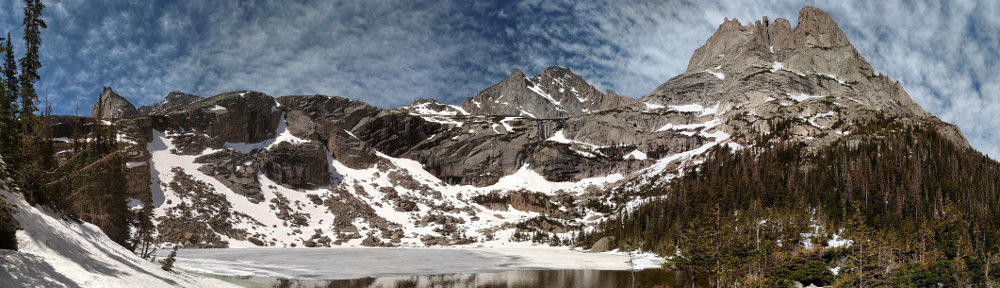
Frozen Lake panorama

Blue Lake in the distance

farther to the west and recommended this route as somewhat easier. We followed his suggestion. I have no basis for comparison, so I can’t say for sure it was an easier way, but on the way down we did get down quite a bit faster than two pairs of climbers who went the other way.


Here’s the time lapse. Cloud motion here is subtle compared to most of the others I’ve done. It starts to sprinkle half way through and you can see the raindrops hit the lens, then dry out.


Shelf Lake, Solitude Lake

Saturday, July 27

I killed Victor.

We hiked to Shelf Lake and Solitude Lake. I don’t know why I have so much trouble finding where we leave the Black Lake trail. When I hiked to Blue Lake this spring I looked for the spot and missed it. I missed it again this time. We went a bit too far up the trail. We headed across a marshy meadow and made an easy crossing of Glacier Creek and headed upslope.

I heard water to our right and knew we needed to be on the other side of the stream so we worked our way over, passing through some nasty deadfall at one point. When I saw the stream, I also saw the trail and knew we were finally in the right place. I don’t think Victor was much of a fan of our little bushwhacking expedition.

We had just started a kilometer section of trail that climbs eight hundred feet. And it’s not really a trail and there are a few places where you need to use your hands. Earlier in the day Victor had joked about not wanting to do the Bataan Death March and here I am leading him off-trail and then up just about the most grueling kilometer of hiking I could have picked.

Here we ran into some other hikers. Two young guys came up behind us and passed us like we were standing still. We may have been standing still. Closer to the top we chatted with a couple coming down. They’d been up there since Thursday, said they’d had a couple cold nights.

2016-08-27 12.08.36_stitch_crop_scale

Shelf Lake

Above the trees it was quite blustery. The sun was shining brightly but it was cool, and the wind was cold. We had lunch at Solitude, trying to take shelter on the lee side of a boulder along the water’s edge. We needed a bigger boulder.

Even though I didn’t expect we’d want to sit there very long, I attempted to set up the GoPro for a time lapse. There wasn’t much cloud action but you never know how things will turn out. In this case, not at all. I couldn’t get the camera to work in multi-shot mode. It kept emitting a series of beeps, showing a message that said “camera busy.” So no time lapse.

2016-08-27 12.39.23_stitch_crop_scaled

Solitude Lake

By the time we got back to the trailhead, Victor could hardly walk. He may never want to hike with me again, but at least he had a memorable day 🙂