Saturday, June 12
After a bit of map study, I came across the James Peak Wilderness. There’s a trailhead at the eastern portal of the Moffat Tunnel. From that trailhead, in about five day-hikes, it should be possible to visit more than a dozen named lakes all above 10,500′. Each of these hikes will take you to two or three lakes.
A couple of years ago, I failed to reach Bluebird Lake in early July because of the amount of snow on the ground. So in mid-June, I should expect to find a fair amount of snow as low as 10,000′. The only one of these five day hikes that doesn’t top 11,000′ is the one to Forest Lakes. The lower, smaller lake sits at about 10,675′ and the larger, upper lake at 10,850′. ProTrails lists this hike as “moderate” while AllTrails says it’s “hard”.
I’ve never hiked in this area before, so I have no idea how crowded the trails are. None of these hikes are longer than ten miles, so they’re not very long. A few of them climb 2,000′ from the trailhead. ProTrails says “The Forest Lakes are part of a heavily used trail system and very popular among anglers. Arrive early to secure parking and avoid crowds.” From Google’s satellite image, the parking lot doesn’t look too big, so how early is early? I set a 7 am target. We were only a few minutes behind schedule and managed to put boots on the trail at 7:20.
The trail skirts the entrance of the tunnel and quickly meets South Boulder Creek, which it then parallels for a bit less than a mile. Half an hour after we began, we reached the Forest Lakes trail junction. The next section of trail, from this junction to a bridge over Arapaho Creek is wide, perhaps wide enough to drive a jeep on, and of an almost constant grade.
The bridge over Arapho Creek has seen better days. It’s a couple of split logs with a railing, but half the railing is gone. The creek carries the combined outflow of Forest Lakes and Arapaho Lakes. Right now it is running robustly, overflowing onto the trail. Stepping onto the bridge, I grabbed the post that formerly held the missing railing. I didn’t put any weight on it but used it only for balance. This is good, as it’s not exactly secure.
When planning this hike, as I said, I was expecting to be hiking over some snow. My guess as to how much snow we’d see was a bit off. This bridge is at about 9,800′ and this is where we started dealing with snow. There were isolated patches of snow almost as low as the trailhead, but those were small, isolated, and not on the trail. From now on it became more challenging to follow the trail, as it quickly became totally buried. The parts of the trail that weren’t covered with snow were rivers of snowmelt. Before long, we weren’t so much following a trail as previous hikers’ footprints.
In planning our little trek, I found conflicting information about the trails. Some maps indicate there are two trails to Forest Lakes while others only have one. About a quarter of a mile after the bridge I was expecting to find a junction with the trail to Arapaho Lakes. That trail continues along the creek to the confluence of the outlet stream from Forest Lakes. Here, maybe, there’s another junction; another route to Forest Lakes.


I never saw the Arapaho Lakes trail. For a while, I wasn’t sure which trail we were on. But after hiking a distance I figured to be much farther than we needed to go to reach that junction, I got the phone out to see what elevation we had reached. By now, we’d gone about half the distance between the missed junction and the lower Forest Lake.
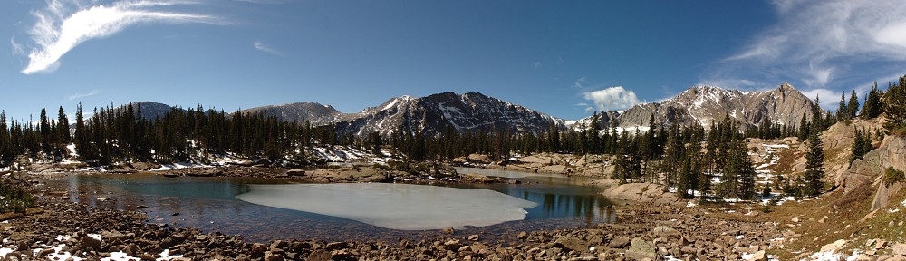
We continued to lose and regain the trail until we could see the lake through the trees. Lower Forest Lake is, as the name implies, in the forest, having trees all around it. We arrived on its eastern shore, which is shaded and show bound. We spotted a rock outcropping sitting in the sun on the northern shore and made our way there. This entailed crossing a somewhat marshy area. Actually, that’s not a great description. All the ground around the lake was covered in flowing water. More than once I stepped where I shouldn’t have stepped and got some water in my boots. This early in the season, the only wildflowers I spotted are those yellow and white ones that grow in abundance in these marshy areas.

Just to be clear, my main issue with the snow involves navigation. Given the route-finding difficulties we faced reaching the lower lake, we decided not to bother trying to reach the upper lake (which would be somewhere roughly in the center of the above panorama). Had I been here before, and been familiar with where we were headed, I’d have continued.
We sat on our rock and basked in the bright, cloudless sunshine for an extended break. It was a bit early for lunch but I’d worked up an appetite and ate anyway. I don’t know what it is about eating on the shore of some alpine lake after a few hours of hiking, but even average food is delicious. My turkey avocado Swiss sandwich on sourdough bread was fantastic. The can of Tommyknocker Blood Orange IPA wasn’t bad, either.
I took the GoPro with me so I could capture a time-lapse video, but we didn’t see a single cloud all day. Sometimes the weather is just too perfect!


On our hike out, we more or less retraced our footsteps. During our break, I’d managed to pretty much get my feet dry, but I quickly made another misstep and gave myself another case of wetfoot. So it goes.
So far, we’d encountered only a handful of other hikers. I was starting to think that perhaps ProTrails had overstated the amount of traffic this trail gets. It may be that the snow was discouraging people from reaching the lake, but from the bridge over Arapaho Creek back to the trailhead we ran into substantially more traffic. Unlike RMNP, dogs are allowed on the trails here, as long as they’re on leashes. Well over half of the hikers we met had dogs with them.
Not long before we reached the trail junction at South Boulder Creek, we heard the blast of a locomotive horn. I don’t know if it was entering the tunnel or leaving it. I was a bit disappointed we missed seeing it. The tunnel is ventilated by giant fans. These fans run for twenty or thirty minutes after the train clears the tunnel. These fans sound like giant power saws and we could hear them from more than half a mile away. I couldn’t tell how they were powered – are they electric or diesel?
We were back to the trailhead a few minutes after 1 pm. In spite of the snow, and of not reaching the upper lake, I found the day quite satisfying. Of course, if I want to visit all the lakes in this area I’ll have to hike this trail again, but that’s quite alright. Lower Forest Lake isn’t the most scenic lake, and the hike is your average forest hike (that is, “you can’t see the views for the trees”), but there are plenty of worse ways to spend a day.
Although it’s possible I could hike all these trails in a summer, I don’t think I’ll make such a concerted effort. This trail had the lowest destination elevation of the group so I figure it’ll be another month before many of the other lakes served by this trailhead are easily reached.