As I’ve demonstrated many, many times, not all my hiking plans come to fruition. But I’m okay with that, as the only important part of my hiking plans is the hiking itself: I’m fortunate that I’m in reasonable proximity to the Park and I’m healthy enough to take advantage of it.
The original plan for this hike was to arrive at the Bear Lake parking lot early enough to get a spot there and head off toward the western flank of Joe Mills Mountain in search of Marigold Lake. Marigold Lake is a small puddle on a forested bench pretty much due east of and upslope from Odessa Lake. It is not to be confused with Marigold Pond, which is pretty much the same size but lies a few yards east of Two Rivers Lake.
I think it’s some sort of joke that the folks who assigned names to bodies of water in the Park have given names to such insignificant puddles such as Marigold Lake but much larger “lakes” are not worthy of being named. I mean, I’m guessing no more people make the trip to Marigold Lake than to either of the ponds on Hunters Creek on the way to Keplinger Lake. Both those unnamed ponds are much bigger than Marigold Lake (or Embryo Lake, and a few others).
I tried to find Marigold Lake last year, along with Round Pond. Round Pond I found, Marigold Lake I didn’t. Near the end of that hike, I decided it would be much easier to locate Marigold by coming off the Odessa Lake trail rather than coming from Round Pond. Time to put that theory to the test.
Wednesday, July 29
I had the alarm set for 5:30, but work up on my own at 5:15. I was out the door promptly at 6:00 and at the Bear Lake parking lot at close to 7:30. So was everybody else. The signs all told me that the lot was full but I had to check it out for myself. It was, indeed, full. I lacked a plan B, and I won’t be riding the shuttle bus until there’s a vaccine for COVID-19. My solution in this case was to make the hike directly from the Park and Ride.
Foster lists the distance from Bear Lake to Marigold Lake as 3.9 miles, with a net elevation gain of 770′. Doing it from the Park and Ride adds about 3 miles and something like 800′ of climbing. It also adds a visit to Bierstadt Lake, so that’s a bonus, I guess.
The skies were clear, but it was fairly windy. Most of the hike would be in the forest, so the wind wouldn’t be terribly annoying.
I’ve never hiked from the Park and Ride before. The hike from here to Bierstadt Lake is a bit longer and a bit more of a climb than from the Bierstadt trailhead, so I don’t know that I’d recommend it over either of the other routes. In the morning, I went around the south side of Bierstadt. It’s only about a tenth of a mile difference, and I figured I’d take the slightly shorter route in the afternoon.
I met a couple who were visiting from California. They asked me if I’d ever seen a bear while hiking and if there were grizzlies in the Park. I’ve seen a bear (and I’ve seen lots of bear poop), but there are no grizzlies here. That answer elicited a further question from them: what does bear poop look like?

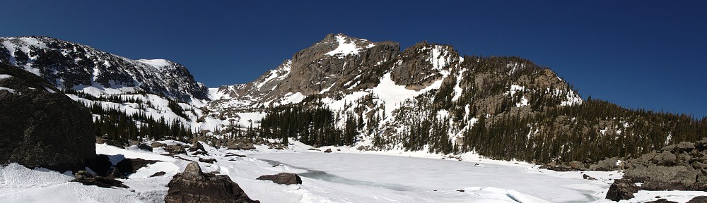
Standing on the eastern shore of Bierstadt, I could (sort of) see where I was going. Joe Mills Mountain is the low, tree-covered mountain to the right of Flattop, in the middle right of the photo. Marigold Lake is on the other side of Joe Mills, a bit north of the summit.
I arrived at the trail junction to Bear Lake in less than an hour and a half, a bit after nine. A few minutes later I passed the trail to Flattop. I felt I was making pretty good time and now could expect to see fewer other hikers. Fewer, but not none. I didn’t run into anybody hiking back; all the traffic was going my way. Between the Flattop junction and starting the descent towards Odessa lake, I passed three groups of hikers and nobody passed me.

In this photo, the Fern Lake fire scar is visible in the distance. A giant talus field (bigger than the nearer one) starts at about the center of the picture and goes up and to the right, bordered by lines of trees. It tops out about where the upper line of trees ends. My plan was to leave the trail when I got to the giant talus field. Traverse that, gaining a bit of elevation as I go, and approach Marigold Lake from above. I was reasonably certain that I passed below the lake when I tried to get there from Round Pond. I didn’t want to end up below it again.
No longer in the forest, I got a better sense of just how windy it was. It wasn’t extreme, but it was unrelenting. It was borderline as to whether I wanted to put on my jacket. At the top of the talus I paused to search for my destination. I couldn’t see it. By now I was toying with the idea that Marigold Lake is a myth; a conspiracy between map makers and trail guide writers to get me out in the middle of the forest searching for a non-existent puddle of water.

I worked my way to the next pile of talus. Finally, I could see the lake. Or part of it, at least. It’s not much more than a water stain. It’s barely visible in this photo, just below center, above the rocks. It was a little lower than I expected, or I was a little higher. The route finding looked fairly straightforward. But it looked to be choked with a combination of krummholz and willow. I decided I didn’t want to deal with that. Given that there’d be no view while at the lake, and with the wind, I decided my best bet for a place to eat lunch would be Two Rivers Lake. So I turned around and headed back to the trail. Knowing now its exact location, I’m happy to make a return trip starting at Bear Lake rather than three miles farther away.
Given that Two Rivers Lake is less than a hundred yards from the trail, I’m always somewhat surprised that it can’t be seen from the trail. And, given its close proximity to the trail, I’m always a bit surprised that it’s such a pain in the ass to get to from the trail. There is a little trail that goes to the north shore of the lake, and I followed it. But there wasn’t a suitable place for lunch there, so I worked my way to the east.
I couldn’t stay very close to the shore, and as I worked east, the separation got larger. I finally had to force my way through some krummholz to get back to the shore. At the eastern end of the lake, there are a few rocks that would make suitable seats. I was looking for a rock in the sun but out of the wind. There was no such thing anywhere I could see. So I gave up and started back to the trail.

Returning to the trail along a different route, I almost immediately found myself on the edge of a small pond, almost attached to the lake. I was out of the wind here. The view was not as dramatic as Notchtop, but it was worth it to get out of the wind. I sat there long enough to eat and no longer.
On the way back, I didn’t go fifteen minutes without running into other hikers. Often, they were resting. None of them bothered to get off the trail to do this, and some of them picked the narrowest parts of the trail to do it on. I thought this showed a lack of situational awareness in this time of pandemic. It would be really easy to stay far enough apart that nobody would need to put on a mask, but so many people don’t give it any thought.

I took a short break where I had a view to the east. Probably every time I hike this trail, in either direction, I pause here for a sip of water or just to take in the view. This time, I sat for a few minutes and munched on some trail mix. Bierstadt moraine stretches before me, with the lake clearly visible, the reverse view of my picture taken from the shores of Bierstadt Lake this morning. I’d be hiking along there soon, just to the left of the lake and then dropping off the eastern end of it to return to my car.
I fully realize that my desire to visit to Marigold Lake is simply to tick a box: been there, done that. It has no particularly interesting attributes. It’s for the completist. I didn’t tick that box today, but I’ll be back, fully understanding that the pleasure in the achievement is much smaller than is warranted by the expenditure of the effort to get there. Particularly if it takes three tries!