Monday, June 22
Sometimes I’m my own worst enemy. This time on “What Did I Forget?”: mosquito repellent and a map.
If I were to follow my usual naming convention, this one would be “Julian Lake FAIL” instead of “Onahu Creek”. It’s good to have goals, but just about any day in the Park is a good day, even if I don’t get to where I originally wanted to go. So for today’s hike, let’s just call it a reconnaissance instead of a fail.
The Foster guide tells us there are two routes to Julian Lake: one is via Timber Lake and the other is bushwhacking up Onahu Creek. The Timber Lake route would be a five-mile hike to Timber Lake and then basically go straight up 700′ and down 700′ in less than a mile. I’m not a big fan of descending steep slopes, so I figured the bushwhack route would be my best bet.
To get there this way, start at the Onahu Creek trailhead and hike about three miles to Onahu Bridge, which is where the trail crosses Onahu Creek for the second time. Then leave the trail to follow the creek. Near Julian Lake, there’s a confluence of the lake’s outlet stream with Onahu Creek. Follow the stream on the left and climb the last 500′ or so to reach the lake. Sounds simple, no?
I really only had two concerns. First, the lake sits above 11,000′ and it’s still June and there may be too much snow. But looking at the map/satellite/aerial photos it appears that the last few hundred feet of climbing are up a gully that has no trees and has southern exposure. I took the microspikes with me just in case. And, second, I might have to ford a stream if I can’t find a better way to cross. My bruised foot is still pretty tender. It’s not a problem at all with a shoe or boot on, but barefoot on stones in a stream might cause some real discomfort. I figured I’d “burn that bridge when I try to cross it”.
This is the second time I’ve been on this trail. The first time, I only went to the first crossing of Onahu Creek, then headed off-trail to Chickaree Lake.
The first bridge is about half way to the second, both in distance and in elevation gain. Immediately after crossing the first bridge, the trail climbs pretty steeply. It’s a pack trail. I’m pretty sure they have “building codes” for pack trails. All over the park I can find pack trails that climb as steeply as 400′ in a kilometer. I’m sure the code doesn’t mix units like that, but this is one of those 400’/kilometer climbs. After that, the trail levels off for the rest of the way to the second bridge.
My decision here was, do I go up the left side, or the right side? From my map study, I recalled that there are two streams that come in from the left and one from the right. But going up the right side, I’d have to cross Onahu Creek itself, so that’s two crossings either way. I picked the right side and dove into the forest.
Almost immediately I found myself in a maze of deadfall. No, “maze” doesn’t do it justice. There were a surprising number of downed trees, trunks in every direction, sometimes stacked three high. I soon came to a small trunk, only about ten feet long. The top half looked like it might make a nice walking stick, so I broke it in half. I broke it exactly where I intended, but the fatter (discard) half bounced up and clobbered me in the neck. As I said, sometimes I’m my own worst enemy.

After quite some time working through the deadfall forest, I found a game trail that looked promising, but it veered off in the wrong direction, so back into the thick of it, although it wasn’t nearly as bad as before. After a while, I came across a fairly well-traveled game trail. It was much easier going until it dumped me out on the border of what looked like a grassy meadow. It was a marsh. I managed to make my way across without getting wet feet, but I saw no game trail on the other side.
Back into the mess. My strategy was to keep the creek fairly near. Not necessarily always in sight, but always audible. In some of the steeper sections, the creek came down some nice cascades. The nasty deadfall wasn’t a constant thing, but was quite common. The worst of it was on the steeper slopes.

The mosquitoes were the worst I’ve ever dealt with. They weren’t big, the sort that would carry off small children. But there were millions of them. Swarms of them. I tried not to stop more often than necessary. It has been my experience that they’re worse in the woods than in the clearings, but not today. I stopped to take very few pictures and every time I stopped to take a sip of water, three or four would land on each arm while others would buzz my ears and go for the back of my neck. At one point there were three lined up on my arm, a few inches apart. I rubbed my hand up my arm, killed the mosquitoes and left three smears of my own blood.
I easily crossed the tributary that came in from the right and figured I didn’t have that far to go, perhaps another mile. The terrain became steep again, and I came across another nice cascade. At the top of this, I was once again standing on the edge of a swampy meadow. The creek flowed right through it, rather than beside it, so it meandered. The channel was narrow, deep, and swift. Narrow for the amount of water; too wide for me to vault it. In this meadow/marsh, it looked like there was a confluence here. I was expecting a steep grassy slope after the confluence, but there was a talus field over there. Perhaps I’m misremembering the map. But this looked like where I needed to cross Onahu Creek and follow the other stream to the lake.

I found a crossing, then went about following the other stream. I had been faked out: it was a meander loop that was now cut off from the main stream. It made a loop to nowhere. It was now a bit after eleven. I hadn’t really stood still for two hours and I was hungry. I decided I’d find a flat rock in the talus, in the sun, and hope that the mosquitoes weren’t so bad. So that’s what I did. And the mosquitoes weren’t a problem at all.
It wasn’t as sunny as I was hoping, and it was a bit on the cool side. After sitting for a while, it was cool enough that I donned my rain jacket. It occurred to me that I could wear it on the hike back to the trail to help with the mosquitoes. I could even put the hood up to protect my neck and ears. I’d be hot and sweaty, but I figured that was a fair trade.
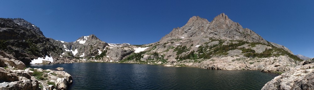
I relaxed for an hour. The view was not dramatic but pleasant. After I ate, I spent a few minutes looking at the terrain. My phone said I my elevation was 10,607′, and the lake is at about 11,100′. Is the lake above the gully to the left? It doesn’t look like what I was expecting from the aerial images. I thought about how disappointed I’d be to learn that I was really close but gave up.

I was quite happy using the walking stick. Perhaps I need to rethink my attitude about using poles. One consideration is that I nearly walked away from my stick twice, once when I started back down, once right after my first stream crossing. I can easily see myself losing my poles.
On the way out I was a bit more successful following the game trails. I found myself on a section that I avoided on the way up, thinking I didn’t like the direction. It was a very easy trail, nearly a straight line with almost no deadfall. Whenever the game trail looked to be forking, I tried to pick the route that looked better traveled. Or had more elk poo!

In the steeper parts, I lost the game trail but I always managed to get back to it. I had less success crossing the marshes. The only time I found the trail on the opposite side was crossing the last of them. This was the “heavily-traveled” game trail from the morning. But it turns out that it isn’t a game trail, it’s an unimproved park trail. If I’d have gone another 20 yards after crossing the bridge this morning, I’d have seen it and saved myself a bit of trouble.
Now back on the main trail, I tossed my walking stick into the underbrush and headed back to the car. This trail really doesn’t go anywhere, and it has a small parking lot, so I wasn’t expecting to see any other hikers. Very quickly, two groups of hikers passed me in the other direction, one group of four, the other of seven. Then I caught up to a group of eight heading my way. I was reluctant to pass them, as I was planning on refilling my water at the first bridge. I’d just have to pass them again.
But they saw me and stopped to let me by. I hustled down to the bridge and refilled my bottle. I’m not sure how long the UV light stays on, but it seems like ages. So the big group was going even slower than I thought, as I was back on my way before they showed up. Near the parking lot, I passed one more group, who were just hitting the trail. So that’s four groups totaling more than twenty people. In the parking lot, there was my car and two others. Seems to me there should have been more cars.
My last decision of the day was which way to return home. I decided that, even though it’ll take a bit longer, I’d go over Trail Ridge Road. I’m still curious about the timed entry passes being 60% of normal, so I wanted to see how bad the traffic was.
I was pleasantly surprised. The parking lot at the Alpine Visitors Center was less than half full. All the pulloffs between there and Rainbow Curve had empty spots. I never had a clear road in front of me, but we generally went the speed limit over that stretch. We caught slower traffic at Rainbow Curve, but it wasn’t as slow as I ordinarily see at that time of day.
Postscript
I have more than a dozen mosquito bites on each arm. One bite has another bite right on top of it. But it could have been worse: I could have been wearing shorts. I’m quite confident that wearing the jacket on the way out, although not exactly comfortable, was a wise decision.
It turns out I made it to within a mile of the lake. I had not much more than another hundred yards of forest to bushwhack through, then cross another marsh and finally climb to the lake. I’m thinking that if I try again, in August perhaps, when the ground will be drier, I should be able to make it. Hit the trail a few minutes earlier, follow the game trails better, and (of course) remember the mosquito repellent!
As with humans, I thought all large mosquitos were harmless, because they are all male. When they carry home a pullet, it is for the bloodthirsty goils. Their bite is equally sinister. Those big red swells are because you had the temerity, conscious or no, to disturb them during their meal of your blood. If you annoy them, their irritant is left behind when their drill (Freud would have had much to say) is removed ahead of plan.
You seem to be suggesting I’d be less uncomfortable had I let the bastards bleed me dry.