Hutcheson Lakes

About a week ago I decided it was time to hike to Cony Lake. Last time I tried to hike to Cony I took a break at Pear Lake where I managed to leave my the SLR and tripod. Although the mission was aborted, I enjoyed a long lunch at Pear.

It’s 9.2 miles to Cony. I’d forgotten how long it was until I checked the Foster guide for a refresher. I wasn’t sure I was ready for an eighteen and a half mile hike. I spent a couple days telling myself I could do it. By Friday morning, there was no wavering. All systems go for a 6am departure, boots on the trail by 7:30. Last year it took me three hours to get to Pear. It’s 2.2 miles from Pear to Cony, so that shouldn’t be more than an hour and a half. Two hours tops. Lunch at Cony by 12:30, half hour lunch, back to the car by 6pm.

Saturday dawned cool and cloudless but a bit hazy – smoke from the fires in Washington and Oregon? I hit the road a few minutes behind schedule but traffic was light and I put boots on the trail promptly at 7:30. I brought micro spikes with me, but at the last moment decided not to carry them.

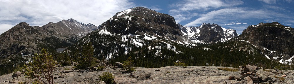
The trail climbs steeply from the parking lot to the top of the first ridge, about six hundred feet in a bit over a half mile. The climb ends with a hairpin; turning west the trail borders a meadow then enters an aspen grove. At the junction with Allenspark trail, another long climb begins – six hundred more feet in a half mile. Shortly after the junction we enter the eastern end of the burn area from 1978. Nice views of Meeker, Longs, Pagoda, and Chiefs Head can still be had, but the trees are getting big enough the view will not be do open for long. From this vantage point, it’s clear how Chiefs Head got its name.

From here the trail flattens out again before a short descent to Finch Lake. We are five miles and 1400 vertical feet from the car in a shade under two hours. Finch Lake isn’t much to my taste – what it lacks in a nice view it makes up for with an abundance of mosquitoes. To now I’d only encountered a few hikers. Here I met a large family. They spent the night here and asked me about the trail to Pear.

From Finch to Pear is two miles and seven hundred vertical feet. Two short steep parts with an interlude in between. The east buttress of Mt. Copeland rises from the forest on the right as we pass a small pond on the left.

Pear Lake was a reservoir for most of the 20th century. There’s still a visible bathtub ring, but the vegetation is slowly overcoming that. Even another thirty years won’t erase all evidence; a large boulder on the northwest shore will be two toned for some time to come. I made it in three hours almost on the dot.

Last year I went around Pear lake to the right. I followed Foster’s route and took the vague trail on the left side. This petered out pretty quickly and by the time I started climbing I was on my own. A short distance away were some folks getting situated on a large rock overlooking Pear Lake. By now I’d seen only about a dozen people.

A small stream feeds Pear here, not a large amount of water, but in several small courses braided up the hillside. I went up the east side, far enough away to avoid the marshy spots. There are a couple of unnamed ponds showing on the map here, and perhaps a couple more that aren’t on the map. After passing one of these I came to the top of the ridge and saw Middle Hutcheson Lake below me.

I headed down the hill a bit to Cony Creek. According to the map in Foster’s guide, I should cross to the south side of the creek about here. It runs in two or three major channels and I could cross it fairly easily. But after having a good look around I decide to stay on the north side. After climbing a hundred feet or so, I saw another hiker on an outcropping below me, on the south side. I don’t know that he saw me; it didn’t look like he was climbing any further.

I didn’t want to deal with the krummholz and willow, so I tended to be higher on the slope. Just below Upper Hutcheson Lake I saw an older couple headed the other way. The were a bit upslope of me and said that was the better route. A few minutes later I arrived at the ponds immediately below Upper Hutcheson and saw another couple. They had been to Cony before and thought it was too early in the season to continue to Cony. There was too much snow. I followed them through a couple patches of willow and to the shore of the lake.

It was 12:15. From here, I’d have to cross the talus slopes above Upper Hutcheson to the inlet, then up two hundred feet to the ledge that hold Cony. I quickly decided to stop here and put Cony on the to-do list for some August or September. Even had I brought the spikes, I was still at least a half hour from Cony. Next time I try this, I think I can save at least fifteen minutes between Pear and Upper Hutcheson having now scouted the route.

I set up the cameras and ate my lunch. The clouds building over the divide were darkening and at 12:40 it started to sprinkle. I packed up and started down. The couple were fishing and decided to wait out the squall. It took me an hour and a half to hike up from Pear but only an hour down. I considered stopping here for a fruit break. The few sprinkles had stopped pretty quickly, but now it was starting up again with bigger raindrops.

By the Pear Creek campsite the sun was shinning again. Here I met a back country ranger. We chatted for five or ten minutes. I learned that much of the park is designated wilderness. I thought it was just a park, but everything a mile from any trail is wilderness. I refilled the water bottle from the creek and headed to Finch. To my chagrin, my knees started getting a bit sore on the steeper downhill sections.

I polished off half my remaining fruit but didn’t dally long. The mosquitoes made a snack of me. I carry some mosquito repellant wipes in the pack, but the seal had broken and they were dried out. Oh well.

On the uphill section immediately after Finch Lake, I came across a couple who had spent the night at Pear Creek. As it was mid afternoon by now, I asked what they did all morning. They had hiked to Cony Lake. Somehow I didn’t see them, but they must have passed me while I was eating lunch. They described their route and said it wasn’t difficult even with the snow.

After this point, my progress slowed considerably. Every downhill stretch gave me a fair amount of pain in the knees. This sometimes happens, but not often. In my ignorance, I will blame it on taking such a long hike without getting in proper hiking shape. I don’t normally tackle the longer hikes until I’ve done a few intermediate length ones first.

By the last mile, fatigue had set in as well. Too tired to properly pick my feet up, I was now stumbling over roots and rocks. This added to the discomfort. The first couple times I rested, my knees felt better for a while, but for the last couple of miles rest did not aid. I made it to the car promptly at six; were it not for the pain I would have finished 30 or 45 minutes earlier. So it goes.

Timetable

Up Down
Trailhead 07:30 AM 06:00 PM
Allenspark Trail Jct 08:05 AM 04:55 PM
Calypso Trail Jct 08:30 AM 04:25 PM
Finch Lake 09:25 AM 03:05 PM
Pear Lake 10:35 AM 01:45 PM
Upper Hutcheson Lake 12:10 PM 12:50 PM

Twin Sisters

The first time I hiked Twin Sisters was roughly thirty years ago. Saturday I hiked it for the second time.

I barely remember the trail. Relentlessly uphill, but not very steep. No streams or lakes, so you have to carry all your water. Not a long hike, and not much higher than many lakes I’ve visited. The only real thing Twin Sisters has to offer is the view of Long’s. That’s about all I remember of it. Lately, I’ve been thinking it might be fun to make this hike and try a time lapse of the sunrise on Long’s. When I saw the hillside after the floods I wondered if it affected the trail. I really had no idea where the trail was. So before I could consider doing the hike in the dark, I’d better know where I’m going.

I wasn’t too worried about getting an early start. Even if the parking lot at the trailhead was full, I could park at the East Lily Lake lot and add an extra four tenths of a mile each way. When I got there at nine I wasn’t surprised to see people parking on the roadside, so I didn’t bother going any farther and parked as well. I walked past about a dozen cars to see that the road is closed at the hairpin. The road above here severely damaged, passable only by four wheel drive.

At the trailhead, a notice about the flood damage included a map. The lower section of the switchbacks had been erased. About a half hour into the hike I arrived at the slide area. It’s flood damage, but considerably different than the Lawn Lake flood.

Change is constant. Although we think of geologic change being slow, it’s made up of short bursts of transformation. In the last few years, I’ve been able to see the effects of these dramatic events. I was on the trail to Bluebird Lake a few weeks after an avalanche tore through a section of forest. I hiked through burned forest a few weeks after the fires. I hiked to Lawn Lake shortly after that flood. I hiked from Mills Lake to Black Lake on both winter and summer routes shortly after the microburst there. And now this one. Is it a flood or a landslide or a little bit of both? In any event, nature’s power revealed.

The trail crosses the slide only once. The trail rises to a switchback and when it reaches the slide area again, a temporary trail climbs more or less straight up the hillside to the next section of trail. Repeat two or three times. Looking on the bright side, there are now nice open views here.

After the switchbacks the trail circles around to the north slope, giving a nice view of Carriage Hills and Lake Estes. If I’d have brought my long lens, I’d have looked for the house on Ramshorn. My pace slowed considerably here. To this point I’d only been passed by two pairs of hikers while passing quite a few people. A couple I had passed earlier looked like they might catch back up, but they slowed down when we timberline.

Technically, I didn’t actually summit. I went to the right of the antenna and found a spot to set up the cameras, eat my lunch and relax. There were quite a few people here, and perhaps an equal number on the near summit. I saw only a few hikers on the other summit.

The day was beautiful. I had to put the windbreaker on while having lunch, it was pleasantly cool with gusting winds. There was no handy ballast to secure the tripod for the SLR, but the GoPro sat low enough to the rocks to not be too affected. I sat there for about an hour watching rain clouds scud in from the northwest. I packed up and left before they arrived and only got sprinkled on for the last few minutes of the hike.

Ford GT

It was only the second time I met Kent when I asked him what I had to do to drive his Ford GT. This was on the Braille Rally last year. I was delighted when he answered, “Buy me a six pack of craft beer.” Unfortunately, he left before I exchanged contact info with him. Since then, I’ve been keeping my eye out for him. I finally connected with him at the Concours a few weeks ago.

I asked him if his offer was genuine or if it was just a polite way of putting me off. He responded that the price had gone up to two six packs and we exchanged cards. One Friday he emailed and said I could drive it that Saturday. I had plans and felt it would be poor form to cancel, so I told Kent that didn’t work for me. Then I worried I wouldn’t get another chance.

But persistence won out and we arranged to get together yesterday for a beer. So with painters tape holding one turn signal in and the other one missing, I drove the Elise to Kent’s. I even was lucky enough to score a parking spot right in front of his house. We went to his garage and he gave me the nickel tour. He has some very nice automobiles, any of which I wouldn’t turn down an opportunity to drive, but the Ford GT stands out for me.

I can’t say that the GT is the car I most want to drive of all cars ever made. I can only dream of driving an F1 car. Likewise, I’ve never even laid eyes on many supercars you see on Top Gear. At museums and auctions I’ve seen dozens of fantastic cars that I never had any realistic chance of even sitting in, let alone riding in. But I’m hard pressed to come up with any other car that given a chance to drive that I’d choose over of the GT.

2014-07-04 16.29.45sMy specific request was, “I don’t even want to drive it fast, just around the block.” So after the tour of the garage, he backed the GT out and we headed to Strange Brew for beer. On the way, he gave it just a little kick in the pants. Just that little squirt of the throttle was … sublime.

But before quenching our thirst, we switched seats and Kent directed me on a short circuit of the area. We got on I-25 and then immediately off. I really wanted to punch it but I took it easy – you never know what other drivers will do. Then we made a wrong turn and had to turn around. I made Kent a little nervous when it took me a couple tries to find reverse, but we made it back to the Strange Brew without incident. I’m used to getting a lot of attention in the Elise, but I don’t think I ever had a guy in the next lane at the light yell at the top of his lungs, “That is an awesome car, man!”

Over beer we swapped car stories. His are much better than mine. It started raining when we were chatting and Kent needled me a bit – “Now I’m going to have to wash it.”

2014-07-04 16.29.54sIt took me quite a while to stop calling these cars GT 40’s. When the GT was at the SEMA show in 2003, it was labelled GT 40. But there was an issue with rights to the name, so it ended up just Ford GT. Kent has a small poster made from materials from that SEMA show in his garage. And he had GT 40 graphics made up and applied to the doors.

I was quite surprised how easy the car was to drive. I was expecting a brute. It was quiet, had a smooth ride, was comfortable. It has leg room to spare; I did not drive with the seat all the way back as in most cars. It’s a very wide car, the driver and passenger sit quite far apart. Rear visibility was a bit worse than the Elise. The wing mirrors are small, and the a-pillars are so big if you’re short you won’t be able to see the one on the drivers side. And ingress and egress require a wide parking spot – you pretty much have to open the doors all the way.

I can’t thank Kent enough for letting me drive his car. We’re barely acquaintances. And I understand why exotic cars don’t get driven much, but I always kind of felt that a car that isn’t driven isn’t fulfilling its destiny: cars are made to be driven. So I think it’s great that Kent drives his cars, and I’m happy he shared his passion with me.

SAAC/CECA Track Day, HPR

High Plains Raceway had club days on both Saturday (Z Car Club) and Sunday (SAAC/CECA). Being a cheapskate, I’d have rather run with ZCCC because they were forty bucks cheaper but we had a garage sale Saturday so CECA it was. Plus, it was the LoCo track day as well, an added bonus.

The day started on a bit of a down note. On my way to the track, on I-70 near East Colfax, my right turn signal assembly popped out. It has happened three or four times before, but this time the wire failed to tether it and it was gone. I spent a few minutes looking for it, hoping it made it to the grass and might be intact. But no luck on the search.

Arriving at the track, I spotted the LoCo contingent and joined them. I bummed some tape from Pete and secured the left side turn signal and covered the gaping hole on the right. I had invited Bill and he surprised me by getting there before me. I grabbed a breakfast burrito the size of my head. Took me the entire drivers meeting to eat it.

It looked to be the usual CECA contingent – Corvettes, Vipers, Porsches, a classic Ferrari, Mustangs, old and new, Minis, Miatas, and Subarus, a couple BMWs, a couple NSXs. In the Lotus paddock we had an Evora, two Exiges, and a handful of Elises. Perhaps the highlight of the day was the brand spanking new McLaren 650S.

I ran in the red group, which I think was the smallest group. Of this group, only a few cars were slower than me. Today we were short handed on corner workers, so the only legal passing zones were the straights – couldn’t pass in the short chute between 6 and 7. Bill decided to sit through the green group classroom session, so I was without passenger the first session. I had the soft top on for the first session, then took it off for the rest of the day.

In the second session, the McLaren came up behind me pretty quickly and I was able to wave him by without slowing him down too much. Lucky for me, he caught up to traffic right away and I was able to run close behind him for a short spell.

At lunch they did some parade laps and a ladies only session. Anybody could do the parade laps, so we sent Bill out. When he came back a short while later I thought he was done, but he had time for one more lap so I got a ride in his almost new Taurus SHO. I wasn’t aware they were making them again.

Most folks left after three sessions. They ran green and blue together for the fourth session. So few cars were out, the let the reds back on track. I ran 15 timed laps that session (as opposed to 10 or 11 in the others) and even came in before the checkered flag.

On the way home I stopped again to try to find my turn signal. I walked maybe a mile of that highway, between morning and afternoon. I got back in the car after seeing the same crumpled license plate on the shoulder and was about to shift to second gear when I saw it. Unfortunately, it hit concrete instead of grass. The lens and bulb were gone, and it was missing pieces and badly cracked, but surprisingly still had the grommet.

These things are on back order from Lotus, so no idea how long I’ll have to do without it. I wonder if you can get green or yellow painters tape…