Saturday afternoon, after we returned from Estes Park, we headed down to the Alamo Drafthouse Cinema to see Ron Howard’s new movie “Rush”.
This particular screening was put on as a fund raiser for Auto-Archives. The original plan was that this screening would be the first showing after the premieres in London and LA. That didn’t work out, but so it goes. The event was sponsored by Ferrari of Denver and about a dozen other firms and was attended mostly by car club members. The theater seats 200 people and fully a quarter of those in attendance were Lotus Colorado members.
A side note here. I’m on the mailing list for Circuit of the Americas, the track in Austin, TX where F1 now holds events. I received an email about a week ago from COTA inviting me to a “Rush” premiere event which they are sponsoring at the Alamo Drafthouse. I had to look closely – this was for an event at the theater in Austin.
The evening started off with a little car show. Most of the close in parking was roped off for the car clubs. I didn’t count, but my impression was that we had more Lotus Elises than Ferraris of all models. We also had the usual assortment of Elans, Esprits, Evoras, and Caterhams. There were several models of Ferrari and a smattering of other notable cars including a Mercedes McLaren and an Excalibur. Also, in the lobby, a club member brought his Formula B Lotus 69 for display along with a bunch of other memorabilia from Auto-Archives.
We hadn’t been to the Alamo Drafthouse before. This is a chain of movie theaters that serve dinners during the movies. I was expecting a single screen facility for this but it turns out it’s a multiplex. We were in auditorium 7. For this event, we all got our choice of entree from a somewhat restricted menu and one alcoholic beverage each. We were told that this was the first time this auditorium had been sold out for a movie.
The theater is much like any other multiplex except that the rows are a bit farther apart and there are small tables attached to each pair of seats. Wait staff came through before the film started and took our orders. It took quite a while for everybody to get served; many of those around us got food before we did, but we all got served in the dark.
Rather than the usual pre-film viewing – ads and coming attractions – we were treated with a number of old car-related shorts. One was the trailer for Howard’s first movie, “Grand Theft Auto”. I’ve been saying for a while that I don’t think he’s made a bad movie. But I don’t remember seeing “Grand Theft Auto”, which looks pretty cheesy.
The food was nothing special. I had a spicy bleu cheese burger and Genae had the “Royale with Cheese”. Turns out it wasn’t so Royale and not so cheesy, either. She had asked for no mayo, no onions. She got that, but it also came with no tomato and no cheese. So it was a burger with a leaf of lettuce. Mine was better – it was constructed to specification. I always figure a burger is a risk-free item. It’s hard to serve a bad burger, but it’s also hard to serve a really good one. This was smack-dab in the middle: a mediocre burger.
Before the movie, the Alamo Drafthouse shows some rules. They’re pretty strict about talking during the film. But this was a special event, so it was announced that “this is our theater. Feel free to cheer for the good guy and boo the bad guy.” My neighbors took this to heart. They not only cheered and booed appropriately, they also talked through the entire movie. Very annoying. But I’m generally non-confrontational and didn’t tell them to STFU.
We enjoyed the movie nonetheless. I stand by my comment that Howard hasn’t made a bad movie yet. This was a fairly true retelling of the 1976 F1 season fight between Lauda and Hunt. Both actors did fine jobs with their portrayals. The action was very well done. We intend to see it again soon, in a theater with a bigger screen and better sound. (Not that the screen and sound at the Alamo were lacking, just that if we’re going to see it again so soon, we should get an “upgrade”.)
Another side note here. A number of times during the film, characters are watching TV or listening to the radio. At one point, we hear a report of the Big Thompson flood. Having just spent the day visiting Estes Park after another flood that destroyed the road through the Big Thompson canyon, it was a bit jarring.
If you’re an F1 fan, I think you’ll enjoy the movie.
Today we drove to Estes Park for lunch. Yesterday I called a couple places up there and asked if they were open and if we’d be in the way if we went up there. “Please come.” So off we went. We drove Genae’s car, not knowing what sort of road damage we’d encounter.
We gassed up and reset the trip odometer and headed west on 88th. This turns into Colorado 72 and goes up Coal Creek Canyon. This road, though, is closed at least until November. We head six miles south to Golden Gate Canyon and up to Colorado 119 north of Blackhawk. Here the traffic started getting heavy. Not many RVs, but lots of side dump trucks running in both directions.
North of Nederland we started seeing evidence of rock slides almost everywhere the road makes a rocky cut. A crew was filling a dumptruck with fallen rocks where the road makes a long cut just before Allenspark. When we passed the turn for Wild Basin, I noted that we’d been driving for two and a quarter hours. In the morning, before traffic, I could probably get to the trailhead in two hours. So a hike here has as long a drive as about any west side hike.
The most dramatic flood damage we saw was at Camp St. Malo. There’s a huge pile of debris on the west side of the road. It looked like the road had been closed here at some point.
Flood debris at Camp St. Malo
The road along here must have looked more like a river. Most of this section of road is narrow because it has no shoulders. The white line marking the lane really marks the edge of the asphalt. Water ran along the edge of the road, washing away big channels of earth.
Landslide on Twin Sisters
It’s clear that an incredible amount of water fell here. There’s a large landslide on Twin Sisters. The bathtub ring in the debris at Camp St. Malo was about eight feet above the top of the rubble. And standing there, you can see a fresh scar on Meeker as well.
After Lily lake the road descends steeply. Here the water undermined the edge of the southbound lane, causing chunks of asphalt to break off, even in the stretch that was recently repaved.
I thought we’d see if we could go far enough down Fish Creek road to go by the house on Rams Horn but it was closed above Carriage Dr. In any event, it had taken over two and a half hours to get here, and we had to be back home by four at the latest so we didn’t have much time. The plan was to grab pizza over by the Safeway then see if I could get some cheese corn at the Carmel Crisp and finally grab some beer at the brewery. So we headed straight to the restaurant – Village Pizza.
I can’t recall ever seeing fewer cars in that parking lot. The place looked closed, but the sign said open so in we went. We were the only people there. Three or four other tables were seated within minutes of us. After enjoying our pizza we headed downtown. I was pleasantly surprised. You could hardly tell the place had been flooded. Plenty of available parking near the post office.
We popped into Carmel Crisp and got some white cheddar jalapeno popcorn. They’ve been there for 38 years and I’ve probably been buying cheese corn there that long. The place really hasn’t changed in my memory, except that they sometimes put another little snapshot on their wall. They have one showing damage from the Lawn Lake flood in ’82.
I asked how long they were out of commission. They said just a short while. They had to wait for their inspection sticker but had the place cleaned up in a couple of hours. They had very little water in their shop. Some time ago their neighbors remodeled and put a wall very close to their front door. Their door is angled, and this wall sort of impedes traffic flow. They went to court over it at great expense but lost. In the end, it diverted the water enough to save them some grief.
Next, pick up some beer. We head up West Riverside Drive, not seeing much damage. Different story at Fun City, though. A fair amount of debris there. After grabbing some Stinger wild honey wheat and Estes Park Gold, we continue up Riverside. I’m happy to see that things aren’t as bad as I’d feared. We didn’t driver through Manor RV but considered it. We did drive slowly to get a good look and saw nothing out of the ordinary.
Up Marys Lake Road and back to 7. Traffic was pretty bad all day. We often saw strings of twenty and thirty cars in the other direction. On the way back was saw more sports cars, sometimes two or three together but nobody was even moving the speed limit. Side traffic often had long waits to cross or enter the highway.
It was more than 180 miles round trip, total elapsed time a tad over six hours but not much time spent in Estes. The roads were in good enough shape to take the Lotus but traffic sucked. But we did make it back in time. We had a date to see a movie, but that’s another post.
Sorry this post is a bit late, I’ve been otherwise occupied.
Saturday, September 21
LoCo’s three day fall drive included a night in Gunnison and a night in Crested Butte. The route looked interesting, but we just have too much to do to join them. Day one, though, featured Independence Pass. I haven’t been over it in the last thirty years or so and Genae has never been over it. So we figured we’d join the group for the drive to lunch in Carbondale.
We met at a gas station near Golden and headed west on I-70. The trip up I-70 to Frisco is pretty scenic as far as interstate highways go, but not exactly a “Lotus road”. We weren’t a big group yet, missing a couple of Denver folks and not yet met with the Springs group. Even so, I was second to last in the string and lost sight of the Henrys behind me. I last saw them before Georgetown and they didn’t catch up until we exited the interstate at the junction with Colorado 91. By now we had two additional cars, both orange Elises.
Fremont Pass isn’t much twistier than I-70. On the northwest side of the highway there are a couple of large tailing ponds where there once was a mountain. And near the summit you can see another mountain being erased. At its peak, the Climax mine was the largest molybdenum mine in the world, producing three-quarters of the world’s output. It was idled in 1995 but put back into production last year, yielding over twenty million pounds per year.
We made a quick stop in Leadville before continuing on to Twin Lakes to meet the Colorado Springs contingent. There we found a patrol car parked on the side of the road with a mannequin in the drivers seat. After a short break we headed up the pass.
Rinker Peak (13,783′)
One of the objects of the drive is to see the turning of the aspen. We were a bit early, but still quite scenic.
Independence Pass tops out at 12,095′ above sea level. Twin Lakes, on the eastern end, is at 9,200′ and Aspen on the west is more like 8,000. It has a reputation for being hair-raising, and I’d say that would have been how I’d described it the first time I crossed it when I was maybe ten. At the foot of the pass, Genae said she’d compare it to Red Mountain Pass. My feeling, nostalgia isn’t what it used to be. I didn’t find it particularly thrilling. For Genae, Red Mountain is still the standard setter.
I did enjoy the narrow parts on the western side. I’d forgotten all about those. There are three or four sections where the road isn’t wide enough for two way traffic. Cars on one side or the other have to wait for oncoming cars. I bet it’s loads of fun in a motor home.
We blasted through Aspen pretty much without stopping. Hit one red light, perhaps. The road snakes through town, right, left, right, left. At one turn, three or four kids had their phones out, getting us on video. Once through town, onto the superslab – not interstate, but damn close, down to Carbondale for lunch.
I didn’t plan the day very well. I considered making a side trip to Maroon Bells. It would mean going back to Aspen, which meant back over Independence to go home. Quite a long afternoon. Instead, we decided to come back to the area and spend a night or two, have a nice dinner in Aspen, take a short hike at Maroon Bells. Perhaps next spring.
So we headed up to Glenwood Springs and I-70 for the return to Denver. A lot more interstate driving than is ideal, but a pleasant day nonetheless. Glenwood Canyon is always interesting. It was recently repaired and all lanes are open both directions.
The Colorado Grand was finishing up in Vale. When we got there, we saw some transporters along the frontage road being loaded up with some of the cars. After Vail is the quick run up Vail Pass. I don’t remember what this one was like before the interstate went through. In any event, most cars make it up at 70 mph. Not exactly a Lotus road.
We stopped to fuel up in Silverthorne for the final blast back through the tunnel, and the run down to Denver. I’m curious what sort of fuel economy we were getting. It’s about 70 miles, which would normally be about two gallons. But the gauge still indicated nearly full. If I burned a gallon and a half, I’d be surprised. Which would mean something like 45 or 50 mpg. (And also means I probably only got 20 or 25 going the other way.)
I had the camera running from Twin Lakes to Aspen, but it’s bad. Within a few minutes of heading out, the lens fogged up. I’ve never had that happen before. If at first you don’t succeed, try, try again.
The Passes
Fremont Pass (11,318′) CD
Named for 1856 Republican presidential nominee John Charles Fremont although he never crossed it. Two narrow gauge railroads were built over the pass in the 1880’s, the Denver and Rio Grande and the Denver and South Park. The most dramatic scenery here is the mine. Entire mountains have been erased, with one undergoing the process.
Independence Pass (12,095′) CD
The town of Independence was named for the ghost town of Independence, founded July 4, 1879. Before that, it was known as Hunters Pass. It’s the highest paved crossing of the Divide but it’s only open in summers.
Vail Pass (10.663′) CD
This pass had no particular use prior to US 6 being put there in the 1940’s. Appropriately, it’s named for Charles D. Vail, chief engineer of the Colorado Department of Highways. Now it’s I-70, pretty much just another stretch of interstate highway.
Eisenhower Tunnel (11,158′) CD
Okay, this is cheating. The tunnel is not a pass. When the project was started it was called the Straight Creek Tunnel. This is two bores, one named for Eisenhower and the other for Edwin C. Johnson, a governor and senator who advocated for the interstate to cross Colorado.
I had a plane ride seated next to the guy who built much of the tunnel’s duct work. He was about ninety and missing a couple of fingertips. Quite an interesting character.
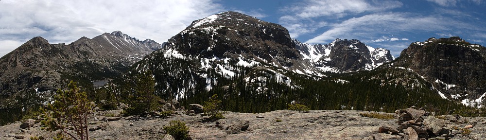
Until now, whenever I fell short of a hiking goal the destination would get placed on next year’s list of hikes. After making a premature turn on my last hike I decided I didn’t really want to wait the better part of a year to make another stab at it. So off I headed to the south eastern corner of the Fall River Pass quadrangle, on the Mount Ida trail towards Gorge Lakes.
Again Trail Ridge Road was traffic-free and fun to drive. I stopped at Rock Cut for a quick look at my destination then headed to the trailhead. I’ve taken photos here several times and was never happy with the result. This time I got a fairly good shot, and include it here. The red line is more or less the route I took, visiting first ‘Amore Lake’, then Love Lake, and finally Arrowhead Lake.
My route, more or less
Poudre Lake was shrouded in mist and a small cadre of photographers was there snapping away. I put boots on the trail twenty minutes earlier than last time and before long passed the point of my errant turn. When the trail got near the edge overlooking what I’ll now refer to as ‘Misplaced Valley’, I wandered over for a closer look.
Not far from there I left the trail and cut across the next ridge to a point where I’d get my first real look on the gorge.
Seven lakes are visible in this photo
A more intrepid hiker than myself might descend here. I’m not a big fan of steep descents, so I continue along the ridge line. My next landmark is cleverly named Point 11819. That is, it’s an unnamed point at 11,819′ above sea level. From here, that’s about a 600′ descent. At this point I considered abandoning the ridgeline and descending straight to Love Lake. It’s not too steep for me, but I figured I didn’t want to miss visiting ‘Amore Lake’ so I continued with the original plan.
Before leaving my vantage point, however, I should have used the telephoto lens to scope out the terrain surrounding the lakes below. Perhaps I’d have seen something to aid in my progress later. I guess I was just too wowed by the scenery to do anything like planning ahead.
Continuing down the ridgeline, I came to a ramp that led to ‘Amore Lake’. This is a pretty little officially unnamed pond. I skirted around the west side of it and went up and over the slight ridge separating it from Love Lake. I quickly found myself in difficult terrain. Trees on a steep rocky slope. I made my way easily enough through these and right into a patch of willow. I started flashing back to my hike to Keplinger Lake. But no worries, I was soon through this patch and descending another ramp to Love Lake.
From here, it looks like Love Lake and Arrowhead Lake are only a few yards apart. It’s more like a couple tenths of a mile and a hundred and fifty feet or so of elevation. Here’s where a bit of forethought would have come in handy. I continued along the west side of the lake, then up and over the slight rise. In retrospect, I think it would have been better to go on the east side of the lake and descend through the trees there. Why? Because I found myself in another giant patch of willow.
Before long, I gave up. You might say I technically didn’t reach Arrowhead Lake because I didn’t get close enough to put my toes in it. I’m going to count it anyway. I perched myself on a rock with a nice view of the lake and the surrounding mountains, set up the camera, and enjoyed my lunch. While relaxing, I surveyed the area in search of a way out that didn’t take me through the willow again. I thought I spied a wildlife trail and when I packed up to go, I headed that way.
This route was an illusion. Short of heading straight up the ridge there was no easy way out. So I forged through this patch of willow without too many new scratches on my legs. A few minutes after muscling my way through I was back on the shores of Love Lake where I refilled my water bottle.
Here I heard voices. I hadn’t seen anybody since early morning when I passed a couple on their way up Mount Ida. I met them at about treeline, more than five hours earlier. Scanning the slope above the lake I saw the first hiker coming through the willow in about the same place I went. He was talking to a companion, suggesting a route. After several minutes I saw four hikers total. Only the fourth found the route I intended to take out, missing the willow entirely.
I chatted with these guys for a few minutes. It was about 1:30 now. They asked if I went along the ridge above us and when I confirmed, they mentioned they’d seen me. This must have been nearly two hours earlier, as I’d spent an hour at Arrowhead. They came via Forest Canyon Pass. If I ever return here, I’ll give that route a shot for reasons that will become clear soon enough. I asked if they were spending the night, but they said that wasn’t in their plans. I wonder how long it took them to return to their car.
Gathering Storm
As we separated, it began to rain. It didn’t look to last too long so I didn’t bother with the poncho yet. The next mile or so from here would be grueling, gaining about a thousand feet. I considered cutting across ‘Misplaced Valley’ and returning to the trail using the same route I explored three weeks ago. The idea was, I’d need to gain about 400′ less elevation. But when I saw where I was, I decided to stay on my route in. To cut across here, I’d have to go down a few hundred feet so there’d be no real savings.
Arrowhead Lake and Mount Julian
So I continued my climb. A few minutes later it started raining again. I had to often pause to take in the scenery. And to take in oxygen. I stopped and faced nearly due east. The wind was at my back, rain coming down at enough of an angle to keep my front dry. Judging by the clouds above me and the prevailing winds, I figured the rain would stop shortly. I continued my slog up the ridge.
Feathered friends
Subtly, the wind shifted. I was under the edge of the rain cloud, but it was now moving south to north. I’d be right under this edge for a while unless the wind shifted back. The rain turned to hail for a short while and I donned the poncho. Looking to the north, things were getting ugly. I saw lightning strike on the other side of Trail Ridge Road. In the grand scheme of things, this is not very far – three or four miles as the ptarmigan flies.
This was not a happy development. I reckoned I was still two and a half hours away from the trailhead, and nearly the entire way is above treeline. I intended to stay well below the top of the ridge in order to gain as little elevation as necessary. This now seemed like a doubly good idea considering the weather. I couldn’t really increase my pace as I was climbing steadily. And I had to cross the occasional pile of rocks, which were now slippery with rain.
I took fairly regular breathers. I’d pick a point ahead, tell myself not to pause again until I reached it, pause for a few seconds and repeat. During one of these many pauses, I heard elk bugling below me in ‘Misplaced Valley’. ‘Tis the season! I wasn’t seeing any lightning ahead of me, but my vision was somewhat limited by the hood of the poncho. Thunder did occasionally boom, reassuringly distant. During my pauses I’d scan the slopes north of TRR – that’s where all the excitement was.
On the way up the Mount Ida trail, both this time and three weeks ago, I was thinking I’d have preferred the trail to be closer to the top of the ridge. Now, though, I was somewhat chagrined that it wasn’t a bit lower. When I regained the trail, I still wasn’t seeing any lightning but the thunder was noticeably more numerous but thankfully still some distance away.
I now increased my pace. The rain was coming down fairly steadily, and my poncho had developed a tear. If I let go of it, the poncho would slip backwards and the tear would get bigger, so I had to keep a hand on it. The pleasant morning walk and the hour lazing in the sun at Arrowhead now seemed like distant memories. I was no longer having any fun.
By the time I reached treeline, the peals of thunder were almost continuous and the lightning strikes were around me in all directions. Thankfully, none appeared to be within a mile, but still too close for comfort. I was happy now to be in the trees. Again I heard the bugle of an elk, much closer now than when I was atop the ridge. Normally, elk are seen and not heard. Today it was the opposite.
When I finally reached the car, it was raining quite heavily. To add to the fun, I had just had the car detailed. It was as clean as it had ever been since I bought it. When getting off the trail, I’ve always been able to sit in the open car door and change from boots to driving shoes but not today – muddy boots in the nice clean car. Oh, well.
It rained nearly all the way to Lyons. Between the three hours or so of rain while hiking and another hour and a half on the drive it was a pretty good downpour. But that was only a hint of what was to come. As I write this, both Estes Park and Lyons are cut off from the world; roads covered by debris or washed away. Nearly a whole year’s rain has fallen in the last couple days. I’ve seen video of downtown Estes Park and the water is perhaps as high as it was when the Lawn Lake damn burst back in 1982.
 This particular screening was put on as a fund raiser for Auto-Archives. The original plan was that this screening would be the first showing after the premieres in London and LA. That didn’t work out, but so it goes. The event was sponsored by Ferrari of Denver and about a dozen other firms and was attended mostly by car club members. The theater seats 200 people and fully a quarter of those in attendance were Lotus Colorado members.


