Colorado State Patrol

Saturday, August 24

After a string of hiking posts, we switch gears and head to the track.

Although I’ll call it a track, the Colorado State Patrol facility on South Table Mountain in Golden isn’t really a race track. It’s a training facility for the CSP. The track is really more like a road. It is slightly crowned and even as a center strip painted on it. Drivers should be careful not to go off here. Not only is the pavement often three or four inches above the surrounding ground, there are boulders hidden in the weeds. Hitting one of these will ruin your day as well as your car.

Because the track is only about fifteen miles from home, Genae kindly volunteered to take my slicks for me. She would drop them off in the morning and when I was done at the end of the day, I’d call her and have her pick them up. I keep telling myself I only have about one more track day on these tires.

I’d really rather use them up at HPR. I’ve run at HPR many times but this was only my second trip here. At HPR, if I go too hot into a turn and go off, I’m not worried about damaging the car. Here, there are those nasty boulders. The street tires give me plenty of notice when I’m about to lose traction whereas with the slicks you’re fine until you’re not. But if this is the only place I can have somebody bring the wheels and jack and tools, so be it.

I stopped to top off the fuel tank at the Shell station a few blocks from the track. Once on South Golden Road Genae caught up to me. I also found myself only a couple of cars behind an orange Elise. It was Eric from Colorado Springs. He passed the bus we were behind and went past our turn. I thought he missed the turn, but he was headed to a different gas station.

The access road to the track is dirt. It was in pretty bad shape last year. But today it was even worse. In spots, it featured a gully that meandered down the middle of it and from my seat looked somewhat like the Grand Canyon. Half way up the road I came across another Elise. He had decided this couldn’t be the correct way and was trying to turn around. Once alongside him, I reassured him we were going in the right direction.

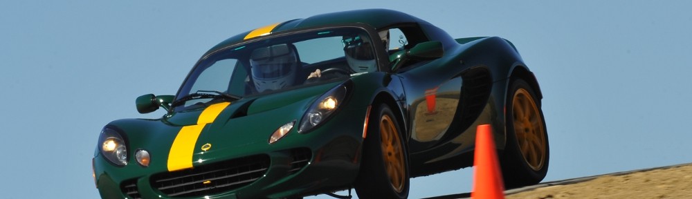
Chris had recently bought his red Elise. It used to be Joe’s car. Joe, sadly, has ALS and had to sell the car. This was Chris’s first track event. Chris, Eric, and I all parked together. I mounted the slicks and had the car inspected. Then the drivers meeting was convened and I checked in to get my bracelet – I’m in the red group today.

At all the CECA events except HPR, drivers must also volunteer to work a corner. I was a bit late signing up and had only a few choices. I asked Eric if he wanted to work a corner with me and signed us up for the last session. The last session was open lapping, so Eric decided he would rather work corners in an earlier session and switched.

As Chris hadn’t been on the track before, I gave him a ride in the first session. Red group was first out. There weren’t very many cars in attendance. I didn’t get the official count, but there weren’t more than a dozen in the red group. Much to my surprise, I didn’t get passed in the first session. I used to go to these expecting to be the slowest car in my group but experience has told me I’m somewhere in the middle. Certainly, it must be that the faster cars got out ahead of me and we weren’t out long enough to lap me.

I was a bit tentative that first session. I had forgotten the finer points of getting around the track – my braking points, the quickest line. And it’s been a while since I ran on slicks. I was supposed to be showing Chris how to get around the track but I was missing the apexes by a mile, too early on the brakes except when I was way too late. But he seemed pretty happy when he got out of the car. The first session was 11 laps, best lap was 1:16.03. Four laps were slower than 1:20.

After the first session, Doug showed up in his silver Elise. He wasn’t there to participate; just to hang out. He didn’t even bring a helmet. I mentioned that I will soon need to replace my brake pads and he offered to show me how it’s done. I asked him how many beers it would cost. He doesn’t drink beer, so he said he’d do it if I’d give him a ride at the next track day. I suggested he borrow a helmet and I’d give him a ride right then.

So Doug was my passenger for session two. I was a bit more consistent. This was 14 laps, but included a trip through the paddock to get away from an inattentive driver. Being in the red group (experienced drivers who have been on this track before), I didn’t expect to find somebody not paying attention. I was catching a Mustang and we both caught a Sunbeam Tiger. He was probably six seconds a lap slower than us. We were behind him for two laps and he never waved us by. The rules today allowed passing only in two places, and only with a wave by. Frustrated, I got off the track and told the stewards that driver wasn’t paying attention.

IMG_0826s

Photo courtesy Doug

My best time in session two was 1:16.21, with one other lap in the 1:16’s and only the laps behind the Tiger over 1:20. Again, I wasn’t passed. By now I had noticed that some of the usual fast cars weren’t in attendance. Alan was there, but in his Corvette (automatic transmission and street tires) instead of his Viper. There was a Viper there, but he was in the Green group. Also in the red group was a Dodge Magnum (a station wagon), an Audi, the aforementioned Sunbeam Tiger, an Alfa Romeo, a couple of Mustangs, and a couple of cars from the 60’s: a GT 350 and an AMX. Oh, and a big Chrysler 300. He was here last year and I recall him being the fastest car on the track. Not today.

I didn’t have a passenger for session three and managed to turn my best times. It was the longest session, good for 19 timed laps. I turned a 1:13.32, three more laps in the 1:13’s, eight in the 1:14’s, and nothing as slow as a 1:20, even when catching traffic. The highlight of the session was running nose to tail with a blue Mustang Boss 302. I may have been the last one on the track that session and waved him by right away as my tires weren’t warm yet.

I ran three or four laps behind him. He could pull away on the straights but I’d catch right back up in the turns. Although he wasn’t holding me up, he waved me by. Then we ran three or four laps with him following me. Eventually, I put him some distance behind me, but that was probably due to traffic more than any speed differential. He had more than double the horsepower of the Elise, but said he sometimes had a bit of trouble putting the power down if he tried to get on it too early when exiting a corner. He also told me he tried once or twice to brake as late as me. No can do. As expected, I was able to brake later than any other car in the red group.

The fourth session was open to all groups. As such, there was more traffic. There were also, finally, faster cars. Eric’s Elise is supercharged. He’s made a number of performance mods in addition – exhaust, aerodynamics, weight reduction. I waved him by in this session and had no chance of keeping with him. At one point, under braking going in to turn 1, he had flames coming out his tailpipes. He was running about 3 seconds a lap faster than me.

For this session, I had the AMX driver as a passenger. He was quite impressed with the car’s handling. Of course, the two cars are radically different. His muscle car (390 CID engine) is nearly 40 years older and twice as heavy. Next time we’re at the track together, he’ll give me a ride.

Session four was 14 timed laps. Fastest lap 1:15.04, fully half the laps in the 1:15’s and again nothing as slow as 1:20. I didn’t get any of session four on video. I spaced out after session two and failed to power down the camera. It ran out of battery half way through session three.

By the end of session four, it was apparent we were going to get some rain so the stewards called it a day. That meant I didn’t end up working a corner. I didn’t plan it that way, but I’ll take it. I called Genae to have her come fetch my wheels and tools. It seems I’m always playing the game “What Did I Forget?” Today was no exception. Early on I realized I forgot sunscreen, so I got a mild sunburn on my face. When I went to swap wheels I discovered I’d also managed to forget gloves. In the morning it wasn’t a big deal. I thought about the gloves when I was half way done with the swap. Gloves would have kept my hands clean.

Now, however, gloves were a bit more important. Brakes get quite hot at the track. Hot brakes tend to heat up the wheels. Proceeding with changing wheels now would result in burnt fingers. Luckily, Eric was still there and lent me his gloves. By now the rain started up, so he sat dry in his car while I got fairly wet. Just as I finished, so did the rain. Perfect timing!

By now I was nearly the last one there. I chatted with the stewards a bit waiting for Genae. There’s a gate at the entrance, which was now unmanned and closed. I’d have to go open it for her to get in. When she finally got there, only one other group was still there. They had four cars and a giant transporter. That’s quite an operation for running club days.

I had a fantastic time. I don’t have a breakdown of my lap times from last year, but selecting a random lap from last year’s video tells me I was a good five or six seconds a lap faster on the slicks than on street tires.

I still don’t have the slicks figured out. I took my pyrometer with me and got temps after each session. The hottest I got them was less than 140 degrees. That’s after a cool down lap, and I have no idea how much the tires cool off in that time. Subsequent research tells me these tires should run between 110 and 140 degrees, so I was at the high end and possibly over.

In any event, I wasn’t willing to push the envelope at this track. With a better understanding of the tires I’m sure I could have gotten another few seconds a lap. But I really didn’t want to go off here. Again, I had a lot of fun.

There are a couple of club dates coming up in September at HPR but I’ll probably skip these. I want to do the day at Pike’s Peak International Raceway in October and I’ll need to get new brake pads before then.

Navigational Error

I’m still in catch-up mode. I used my business trip last week as the excuse for the late report on my Haynach Lake hike. No such excuse this week. It was just a busy week.

August 17, 2013

I won’t exaggerate and say I’ve been over Trail Ridge Road hundreds of times – it’s only in the dozens. And I don’t always stop along the way to enjoy the view. But I have spent a fair amount of time at the Rock Cut looking across the valley at Gorge Lakes, thinking how marvelous it would be to visit them. It has only been the last few years that I’ve even considered actually trying to hike there.

Lisa Foster gives us four possible routes. One way would be to park at the Rock Cut, make the steep descent to the Big Thompson river, find a potentially precarious crossing on a downed tree, then make the climb up the other side. Her description of this route is such that I’m unlikely ever to make the attempt. Another option is up Forest Canyon, which also sounds much too difficult for me. The other two are variations on a theme involving the trail to the summit of Mount Ida, one of which involves a steep descent. I’m not a fan of steep descents.

So I decided to attempt to reach Arrowhead Lake by going up the Mount Ida trail then contouring along the ridge a few hundred feet below ‘Jagor Point’ to ‘Lake Amour’, Love Lake, and up to my destination. I have not been on the Mount Ida trail before. I felt there was a fairly decent chance of spotting some bighorn sheep (which I haven’t seen since childhood) and was looking forward to it since deciding on this hike shortly after returning from Haynach Lake.

The trail starts at Milner Pass, so the most direct route is a drive over Trail Ridge east to west. So far this summer I’ve only driven the road west to east after my west side hikes, always in late afternoon weekend traffic. That means I’ve crawled along in something like a tundra version of rush hour – a nice view, but a frustrating drive in a sports car.

On a Saturday morning before eight it’s another story. I had an almost unimpeded drive; from below Rainbow Curve on the east side to Milner Pass on the west side I only encountered one other car going my direction and was able to pass him as soon as I caught him. Not that I wanted to go particularly fast, but it was a comfortable speed not grossly illegal.

I hit the parking lot in plenty of time to get geared up and on the trail by eight. I again scored the end spot closest to the trail and chatted with another hiker while I changed shoes and strapped on the pack, camera, and tripod. It was then I realized I left my map on the kitchen counter. It’s not the first time I’ve managed to do this, so I wasn’t particularly bothered. It was yet another beautiful morning in the park and I felt I’d studied the map well enough to do without.

Not far up the trail I found this notice:

ATTENTION!!!


MOUNT IDA HIKERS


The hike from here to the summit of Mount Ida is 3.5 miles of exposed tundra without a maintained trail and few reference points. You will need to pay strict attention to weather and terrain. A map and compass along with a strong sense of direction are paramount to a safe return.


Several hikers have been lost in an attempt to return from Mount Ida to their starting point. Don’t be one of them.

I am not deterred. I really did intend to have a map, but I never carry a compass. And I feel I have a strong sense of direction, in spite of making silly mistakes like wandering off in the wrong direction along Grand Ditch on my way to Lake of the Clouds. Ahem.

Not long after this sign I ran into a couple guys loaded down with camping and fishing gear. They were also on their way to Arrowhead Lake. We chatted a bit before I continued on. They had gone less than a mile before taking a break; I would clearly make much better time than them.

Before long I was above treeline and able to take in the view of the Never Summer range and the verdant valley immediately below me. Contrary to the warning sign, the trail looked quite well maintained and easy to follow. In addition, there were several obvious game trails criss-crossing the slope below me. Although saw a deer very near the trailhead, no big game was in evidence. I did see a mother marmot with her adolescent child scurry off the trail in front of me, too quick to get a picture.

Not far above treeline there’s a fork in the trail. I paused here to slather on some SPF and consider my route. Even had I had my map, it wouldn’t have been much help. Though the trail on the ground appears well maintained, it appears not at all on my map. But I must bear to the right, for that leads to the higher ground. So I continue on my way.

The trail isn’t particularly steep, but I paused many times to catch my breath and study the nice views. I wondered how long before I’d see the fishermen on the trail below me. Instead of them, I saw a lone hiker in a white shirt. Every few minutes I’d pause and notice that although this hiker seemed to be standing still, he was closer each time. About the fourth or fifth pause I finally caught him not standing still. He was running.

It was about this time I realized I could use the speedometer app on my phone to determine my elevation. I was at about 11,800′ when he caught me and we chatted. I asked if he’d done this hike before. He hadn’t. He also confessed that he didn’t have a map either and was a bit disconcerted by the warning sign from earlier. He had never been in the park before and was visiting from D.C. I congratulated him on his ability to run up this trail, the better part of twelve thousand feet above sea level.

He continued up the trail ahead of me and there was still no sign of the fishermen. According to my phone, I was now a bit above 12,000′. I looked to the northeast and decided it was time to leave the trail and head toward ‘Jagor Point’, which I decided was ‘right over there’.

I am now forced to decide how to continue this tale. The title of this entry is a bit of foreshadowing. Shall I keep my readers with me in my ignorance of my actual location, or cut to the chase and reveal my error now? Of course, even asking the question here provides its own answer.

Had I had my map, I’d have known I really needed to gain another few hundred feet of elevation before leaving the trail. In fact, I was one valley short of Gorge Lakes. When I reached what I thought was the saddle between ‘Jagor Point’ and Mount Ida, I was perhaps a mile short of there.

Recall that my plan was to contour around this ridge. From my map study, I decided the descent from the saddle was probably too steep for my comfort. But standing where I was I decided it really wasn’t that steep after all. I saw several lakes below me and headed more or less directly toward them, heading to the body of water at the top of the valley.

It was an easy descent, not too much loose talus. I quickly made it to the grassy meadows below. There I saw a few places where the grass was matted down where four or five elk or other large animals had lain down. A bit farther along, I saw an elk lying in a meadow and got the camera ready for a picture. Taking off the lens cap, I inadvertently clicked it against the barrel of the lens. The elk snapped his head in my direction and upon seeing me, he got up and cantered off to the trees toward my right. Dang.

By now it should have been obvious to me I wasn’t where I intended to be. I expected to make about a thousand foot descent from the ridge to the gorge. I probably only went half that distance. The lakes I was going to were substantial, all easily visible from Trail Ridge Road. The ponds I was heading to were much smaller. But I was blissfully unaware. It was a pleasant day and I was in beautiful surroundings. And I have a strong sense of direction.

IMG_9843sI had veered left when the elk ran to the right. A few minutes later, the elk dashed from right to left not far in front of me, followed by another one I hadn’t seen a few moments ago. I snapped a couple photos as they ran by, then continued to the pond in front of me. After a few minutes at this pond I headed down the valley to visit the other “lakes” I had spied from above. The walking was easy. There were a few marshy spots but the few clusters of willow were easily avoided.

I hiked from one lake to another, thinking that if I managed to stay high enough along the base of the ridge I’d soon come to Arrowhead Lake. I made it to the end of the ridge without coming to anything remotely like Arrowhead Lake and still hadn’t realized I wasn’t in the right place.

IMG_9856sOn many of these off-trail hikes I’ve come across piles of bones, bleached white. Some ribs or vertebrae, perhaps a pelvis. Always more than a single bone, always less than a full skeleton. Sometimes I can’t decide what sort of animal it was, and it’s never clear to me how long these bones have been there. This time I found a single leg bone, with skin still attached. Where’s the rest of the beast? Did some carnivore or scavenger make off with just this one?

By noon I had been through this valley without finding a pleasant shore for my picnic, so I found a nice outcropping of rocks with a view of Trail Ridge Road opposite. It was quite hazy due to forest fires in distant Idaho and the clouds didn’t look very entertaining so I didn’t bother setting up the cameras.

IMG_9870sAfter lunch, I worked my way along the ridge in the direction of the Mount Ida trail and an easy hike back to the car. Here well off the trail I found a bit of a puzzle. What is the purpose of these funnels? They don’t look like rain gauges to me, and they’re not hooked up to anything.

I quickly regained the trail and made a mental note of where the hiker should leave the trail to contour below ‘Jagor Point’. Ha ha. I made quick time back to tree line where I ran into a group of hikers led by a ranger. A bit farther down the trail I heard a commotion ahead of me and spotted an elk trotting down the trail. I followed him, snapping pictures. He caught up to a friend where the trail switches back. The two elk continued south, I followed the trail north.

I was back to the trailhead by 1:20, the earliest return to the car all summer. I figured I’d be home pretty early, easily by 4:00. After all, it only took me two hours to make the trip in the morning. It couldn’t take an extra forty minutes due to traffic, could it? Silly question. Of course it could. About a half mile before reaching the Rock Cut I found myself in an impromptu parking lot. This was clearly more than a half dozen cars ignoring the signs instructing drivers not to stop on the road, taking pictures of elk in the far distance. I got the camera out and spied flashing lights at the Rock Cut parking lot. Somebody was having a bad afternoon. We were stopped here for more than a half hour.

When I got home, I consulted the map and compared it to my notes. I visited a lake at 11,500′. There is no lake in Gorge Lakes at 11,500. Nor at 11,350′. So I finally accepted that I’d made a major navigational blunder. But no matter. As I always say when I fail to reach my desired destination, “There’s always another day.” I had a very enjoyable walk in the park, saw some wildlife in its natural habitat, got some exercise, and had a picnic above treeline. What’s not good about such a day?

Maybe next time I won’t forget my map.

Haynach Lakes

I had a business trip last week, so this report from last week’s hike is a bit delayed. Sometimes I can crank these things out pretty quickly, sometimes it takes forever. I thought this one was particularly interesting, so it has taken a bit longer.

Saturday, August 10, 2013

This hike has is the longest (most miles) I’ve hiked in a day, but in the end it turned out fairly easy. I knocked it off in less than nine hours, including nearly an hour at the lake and a couple short breaks on the way back to the car. I wanted to put boots on the trail by 7:30 and to be at Haynach by noon. And I wanted to see a moose.

As it’s been on my list for a while; I spent quite a bit of time looking at the maps. I broke it down into four parts. From the trailhead to the junction with the Tonahutu trail. Something like 1.8 miles and a 600′ climb. This puts you over the “divide” between Tonahutu Creek and the Kawuneeche Valley, the source of the Colorado river. Then 3.5 miles to Granite Falls, edging around Big Meadows for quite a ways and only gaining about 400′. Section three is Granite Falls to the junction with the Haynach Spur trail: 2 miles and 600′. Finally, the last mile and a half and another 600′ gain. The Foster guide has the total distance 8.7 miles and 2,260′ of elevation gain. It’s long, but not much of a climb.

I didn’t quite put boots on the trail on my target time, but did reach the Green Mountain trailhead parking lot at almost exactly 7:30. There were a handful of cars in the parking lot, all covered with dew. I backed into the end spot closest to the trail. It’s a two hour drive from home, up I-70 then over Berthoud pass. Very little traffic, as usual. Around Fraser there was ground fog but cloudless skies. By Grand Lake it was soup – I never saw the lake even though it’s within yards of the road in many places. But it was clear again by the park entrance and at the trailhead.

Based on the weather forecast, I thought there was a real chance it might be cool enough to wear jeans but I stuck with the shorts. It was pretty chilly; I had turned the heater on in the car in Winter Park. When I got out of the car I was thinking maybe I should have worn jeans after all. But the trail starts off fairly steep and I was warmed up before long. This part of the trail was very wet, both in the morning and afternoon.

After a steep start you reach the first meadow. There are three or four meadows near the trail with short climbs in between. Then the trail descends slightly to Big Meadows and meets the lower Tonahutu trail. At just after eight, all these meadows were misty. Near the trail junction, two people were out in Big Meadows talking loudly enough, I’m guessing, to be heard a mile away. Big Meadows is something like a half mile wide and three miles long, wider at the north end than the south.

Then I met a couple on their way back to the trailhead. They had intended to camp at Haynach Lake but had difficulty with the altitude so they stayed at the Sunset camp site instead. They were from Kissimmee, FL. He said he bought a new tent for the trip, but neglected to open the package before reaching the camp site. No stakes. I asked if they’d seen any wildlife. Just squirrels.

Big Meadows

The trail goes north here. At first the trail is adjacent to the meadow, providing a nice view of Big Meadows. Somewhere in here I was hoping to see moose. I stopped and looked whenever there was a nice view but no luck. Soon you pass two derelict log structures; I’m sure that even when they were new they were not much more than basic structure. Next the trail climbs a bit to a junction with the Onahu Creek trail. On the first tree past the sign was stapled a notice.

Trail Condition Warning:

Due to a recent wildfire in the upper Tonahutu drainage various travel hazards exist in the next several miles. Use caution and good judgment when crossing the affected area.

POTENTIAL HAZARDS INCLUDE:

  • FALLING TREES
  • SLOPE INSTABILITY AND MUD SLIDES
  • COLLAPSING TRAIL TREAD
  • FLOWING DEBRIS ACROSS TRAILS
  • DIFFICULTY FOLLOWING DESIGNATED TRAILS DUE TO FIRE DAMAGE
  • DAMAGE TO BRIDGES
  • POSSIBLE RE-IGNITION OF FIRE

I had forgotten all about the Big Meadows fire. The fire started in early June. By the 20th it was declared 95% contained. This meant they had established secure fire lines around it. They expected that the fire might still occasionally be seen throughout the summer, until a significant weather event put it out. In the mean time, the upper Tonahutu Trail would remain closed. I later heard from a hiker that this was the first weekend the trail was open.

Big Meadows fire

At the end of Big Meadows the trail takes a right turn. The valley narrows and you can finally hear Tonahutu Creek. Here is where the fire damage starts. It’s a lot different than the kind of damage the Fern Lake trail passes through. On that trail, it’s the opposite side of the valley that’s burned. Here, the trail passes right through the most devastated areas. Only a few blades of grass are growing. Everything is black – the still standing tree trunks, ground roots, the ground, the rocks. Some of the rocks got so hot a burned layer has broken off.

Granite Falls was not burned. It is an aptly named falls, tumbling down large slabs of granite. Easy access to both the top and bottom of the falls. Above the falls is another meadow. After that is the largest and most devastated burn area on the hike. Pretty much the entire forest below Tonahutu Meadow campsite. Today, not a blade of grass grows there. All the burn areas still smell strongly of smoke, but it is strongest here. This is probably the last spot to go out, just a week or two ago.

East of Tonahutu Meadows at first looks to be undamaged. From here all the way to the creek that drains Haynach Lake, fire dripped down the mountain like wax down a burning candle. Untouched forest for twenty or thirty yards, then a narrow strip that is burned. Many trees are burned only on one side. A few may even still be alive. There are a lot of downed trees here, blocking or partially blocking the trail. I doubt any livestock could pass.

Finally I arrive at the spur trail to Haynach. It starts very steeply, climbing almost straight up the slope, now out of earshot of any flowing water. This section is the steepest part of the hike. The climb moderates, and the trail skirts a meadow giving the first real mountain view of the hike. There are some wildflowers, but nothing like last week. The meadows are stair-stepped here like on the first section of the trail, but with bigger climbs in between. And the meadows are larger and provide nice views of the southern buttress of Nakai Peak.

The trail goes through a couple of these meadows, becoming less a trail and more a faint suggestion of where to walk. Just below my destination, I hear a noise like distant thunder but not very loud. And there are no visible clouds. Then I see an elk. She sees me and is gone before I can get a picture, her hooves hitting rock. Perhaps the thunder was her sister or cousin scrambling over some rocks.

The final meadow before the lake is really a series of large puddles, almost like rice paddies. Shallow enough to grow grass, but quite large. They’re even on three levels, terraced. Long blades of grass float in the deeper sections.

Haynach_fragment_crop

At last I arrive at Haynach Lake. On the map, it looks to me like a hammer-head shark from above, head to the right and in a furious turn, tail fin nearly touching head, with a small dorsal fin between. The trail ends in the grass a few yards from the lake, where the mouth of the shark would be. There is a tumble of large rocks right there, so I set up the camera and dive into my picnic.

While passing through those open meadows I was worried I wouldn’t have many clouds to capture in time lapse, but that wasn’t a problem by the time I arrived at the lake. In fact, the clouds were looking distinctly unfriendly. By the time I took the second bite of my sandwich, graupel started to fall. I could see they were widely dispersed by watching the surface of the lake. Ripples about six feet apart. That didn’t last long, though, and the graupel turned to pea-sized hail and it was coming down fast.

I scrambled to get the SLR out of harm’s way but left the GoPro running. I found refuge among a couple scrawny trees. That, too, didn’t last long. By the time I was done eating it had quit hailing (and never did rain), and some patches of blue sky were visible. I wandered towards the tail fin to get a different view. I thought it was worth the price of admission.

IMG_9818
Scorched earth; rebirth

On the hike back to the car, I had a fruit break at Granite Falls and studied the burned parts in a bit more detail. It looks like there hasn’t been much rain since the fire went out. In a few places, burned material has been washed down the slope like little lava flows. A couple of spots there was enough water flowing to expose unburned ground, badly eroding a few feet of trail. Any sort of moderate rain fall will certainly leave visible scars. And almost all the tree trunks are still standing. I expect 90% of them to fall in the next few years. With dead roots, a fairly stiff breeze will be all it takes. Fire is an integral element of the forest ecology. Lodgepole pine cones often need exposure to extreme heat to release their seeds. But seeing the forest like this, it’s hard to think of it as part of a process of renewal.

There were quite a few more hikers on the lower section of the trail. I didn’t meet anybody for the better part of four hours – between Granite Falls on the way up and a bit below the Haynach spur on the way down – but from Granite Falls to the car I came across dozens.

Approaching the car, I evaluated the day. I’d missed my target starting time but still made it to the lake before noon. Even spending nearly an hour at the lake, I’d be back to the car before 4:30. And I had the unexpected experience of walking through a freshly burned forest. I saw an elk but I didn’t see any moose.

Spot the Moose

Then, not more than twenty feet from my car there’s a moose. The guy hiking in front of me had stopped and was signaling me to be quiet. It took me a few seconds to spot the moose. At first I thought it was a cow but it was a young bull with small antlers. I hike 17.4 miles hoping to see a moose and when I see him, a family piles out of a minivan and takes pictures of him.

Over Trail Ridge Road, traffic not as bad as last time, but still lots of people who disregard all signage. Do not stop on roadway. Use pullouts. Ooh! There’s an elk! Stop the car right in the middle of the road and get a picture! Pullout, shmullout.

I’d have gone home the way I came, but I’m out of beer so I decided to pick up a case at the Estes Park Brewery. Six o’clock by the time I get there, so I call Genae and tell her I’ll eat here. Fish and chips. Traffic not so bad to Lyons, but they had to stop cars to clear a motorcycle from the road. The flatbed arrived just a few cars ahead of me so we got waved by while they were positioning the truck.

A long day, but well worth it.

Timetable

 UpDown
Trailhead (8,800′)07:40 AM04:20 PM
Tonahutu trail jct08:20 AM03:45 PM
Granite Falls (9,800′)09:40 AM02:20 PM
Haynach spur trail10:45 AM01:20 PM
Haynach Lake (11,060′)11:45 AM12:35 PM

Pipit Lake

Sunday, August 4

Within days of my failure to reach Lake of the Clouds, I decided that Pipit Lake would the be the next destination. I was all set to go on July 28 but the weather was bad so I delayed the hike for a week. Then on Saturday night I consulted the maps again and thought perhaps I’d hike to Junco Lake instead. Both Junco and Pipit require reaching Bluebird Lake first, both are the same distance, and Junco is at a slightly higher elevation. At one point I thought I’d make my decision only when I reached Bluebird, but as I’m hiking alone I thought it was better if I had a definite route planned before leaving the house. Always let people know where you’re going.

Before going to bed I decided to stick with the original plan – Pipit it was. I’ll save Junco Lake for next summer.

On my last hike, I walked alongside the Grand Ditch, a water diversion project started a century ago and still in operation. Bluebird Lake features in the history of water projects in Wild Basin, too. Back in 1915 the Arbuckle Reservoir Company received approval from the state engineer to build a dam at Bluebird Lake (Arbuckle Reservoir #2). I’m having a hard time imagining the effort required to get tools and materials to the lake. Bars of steel reinforcement were chained in bundles to an axle beam connecting two wagon wheels, with the end dragging along the ground behind a team of four horses. Sacks of cement were carried by donkeys, as were the parts of the disassembled rock crusher and the car engine used to run it.

Today, the trail between Ouzel Lake and Bluebird Lake hardly looks like a pack trail. While most pack trails in the park are quite wide and much improved, this section of trail is narrow and rocky with relatively few obvious improvements. In places, it’s packed dirt a few inches wide running through waist high grasses. The last section of trail is quite steep, switching back and forth. But I’ve gotten ahead of myself.

I hit the trail a bit before eight on another brilliant, nearly cloudless morning. Based on the cool temps when I left the house, I was expecting it to be a bit brisk at first but was pleasantly surprised it was quite nice – warm and calm. The first few miles of this trail can be quite crowded; the sandals and no water crowd visiting Copeland Falls, those with a bottle of water making it to Calypso Cascades or Ouzel Falls.

Not long after Ouzel Falls, the Thunder Lake trail meets the Bluebird Lake trail. I stopped here for a few minutes to apply sunscreen. After the junction, the trail climbs to the top of a ridge that was burned back in 1978. Lower on the trail, before Ouzel Falls, the forest almost seems back to its pre-fire condition when you’re hiking through it, but from above the fire’s path is still clear. Here on top of the ridge, the forest has made little progress and the views of the surrounding mountains are still clear and dramatic. While the views are fantastic, it means the hiker is left exposed to the sun and wind for an extended time. It was too early to be hot yet, but I was expecting it to be a bit on the warm side on my way down.

Here I chatted with a couple who had spent the night at Ouzel Lake. He said he’d heard moose were in the area but he didn’t see any. “If there were moose here, they’d have been around the lake where there’s lots of vegetation for them. There are no moose here.”

Spot the Hikers

I was dreading, a bit, the section of trail between the Ouzel junction and Bluebird Lake. The trail climbs quite steeply, gaining about a thousand feet in less than two miles. As soon as the trail reenters the forest, there’s a large field of debris left by an avalanche that roared through the trees a few years ago. I stopped here to snack on some fruit but was hounded by mosquitoes so I didn’t dally long.

After a short forest section the trail passes through a series of meadows and rock piles. The meadows are a riot of wildflowers – red and yellow, blue and purple, white. When I say I hiked through mile after mile of wildflowers I’m not being hyperbolic. The last mile or so of the trail to Bluebird, plus the mile from there to Pipit were through these fantastic fields of flowers.

I reached Bluebird in good time. There were six or eight other hikers here, perched on rocks here and there near where the trail ends at the outlet stream. I made my way down into the little chasm the outlet stream passes through; crossed it on some rocks and made my way up the other side. This is where the dam was. There’s no sign of it; a testament to the skill of the rangers who cleared it out. Lisa Foster notes the obvious “bathtub ring” around the lake as indication it used to be dammed up, but I think nature has done a good job of erasing it.

Bluebird Lake and Mt. Copeland

Now on the north side of the lake, I gained elevation slowly as I worked my way west. I wanted to be above a large rock outcropping on the west side of the lake. There is no trail here. I occasionally found a faint path, but the route traverses a lot of talus and I saw few cairns. I made my way up a gully above the rock outcropping and ran into a wall of willow. I immediately flashed back to my hike to Keplinger. But here I was back in the clear after only a few feet and a few minutes later found myself at the edge of Lark Pond.

It occurs to me how many lakes in the area are named after birds: Finch Lake, Bluebird Lake, Lark Pond, Chickadee Pond, Falcon Lake. Those are the obvious ones. Pipit, Junco, and Ouzel are also birds. A few miles away, as the ptarmigan flies, is Ptarmigan Lake. How many more lakes here are named for birds?

Lark Pond

From Lark Pond it’s only a few more minutes and a few more feet of elevation to reach Pipit Lake. I was going to say “walk across the tundra and rocks”, but it’s not really tundra here, is it? I don’t generally think of wildflowers when I think tundra. Although the flowers aren’t as dense here as lower on the trail, they’re still quite abundant. I made a point to walk on rocks where I could. Not just to avoid stepping on the flowers, but the ground is marshy in places as well. It looked to me like water was flowing in braids through this area only a few days ago.

Reaching Pipit Lake, I set up the cameras and tucked into my lunch. There’s no shade here, and no shelter from the wind. But it was fairly calm, so not a problem. After only a few bites I was wishing there was a bit more of a breeze, to keep the rich insect life out of my face. I found it better to pace back and forth a bit.

Pipit Lake pano

I’ve been taking a can of soda with me on these hikes for as long as I can remember. I’ve never had a problem with the carbonation before. But today when I opened the can, it fizzed right out of the can. I kept sucking it up but it kept boiling over. By the time it calmed down, I was left with only about two thirds of a can and a sticky hand. I was nearly out of water now, so it was a great time to refill.

I’ve been using a SteriPEN for about a year now and am quite pleased with it. I used to carry two one liter bottles of water. On the longer hikes, I found myself husbanding my water supply somewhat so that I didn’t run out of water before making it back to the trailhead. Now I don’t worry about it at all. I carry one bottle and the device and can drink as much as I want. On this hike, I refilled twice – once at Pipit Lake and again at Ouzel Falls on my way out.

So after getting more water at the outlet of Pipit Lake, I head back past Lark Pond and down to Bluebird Lake. Before long I see another hiker thirty or forty yards ahead of me. How can this be? I hadn’t seen anybody for quite a while, certainly not at Lark Pond or Pipit Lake. I caught up to her a few minutes later and we hiked together until just below Bluebird. She hit the trail at 5:45 and hiked to Isolation Lake. This lake is nestled at about 12,000′ in a cranny between Isolation Peak and Mahana Peak. Looking at the map, I had decided it was beyond my ability, but she told me the hardest part of the hike was crossing the area where we met. Just angle up the slope a little higher than I went to get to Lark Pond and it would be easy to get to.

Wildflowers abound

Further down the trail, still above Ouzel, I met a couple of hikers who told me they’d seen two bull moose farther down the trail. They were below Chickadee Pond and heading west. The next hikers repeated the story. I kept my eyes peeled and occasionally used the camera’s telephoto lens to aid in the search but no luck. The next hikers I caught up to also failed to see the moose. So, contrary to the hikers I met in the morning, moose are in the Ouzel Lake area if you’re lucky enough to see them.

On the hike out, it clouded up a bit (as is not unusual). This made the section through the burn area more pleasant than I was expecting; instead of dealing with bright sunshine on a warm afternoon it was slightly overcast and quite comfortable.

I took a final break at Ouzel Falls for more fruit and a refill of water. Fatigue was finally setting in and my pace slowed a bit. From Ouzel Falls on down the trail is quite crowded. I could see or hear other hikers the rest of the way.

Back at the car I was approached by a couple of park rangers. “We saw your car and wanted to chat with you.” They told me they’d seen me parked at the Sandbeach trailhead last month and were happy to see I didn’t have any hail damage. Evidently it hailed hard enough to set off the car’s alarm. I had no idea. We talked about how often people take pictures of my car. They were amused that with such natural beauty around people would take pictures of a car in the parking lot. We also talked about the sorry state of the dirt road to the trailhead. It’s in serious need of grading. I had to crawl along quite slowly not to fall into the holes. It’s noticeably worse now than it was when I hiked from the Finch Lake trailhead.

And here’s the obligatory time lapse:

Timetable

Up Down
Trailhead 07:40 AM 04:00 PM
Campground shortcut 08:05 AM 03:35 PM
Calypso Cascades 08:15 AM 03:20 PM
Ouzel Falls 08:35 AM 02:50 PM
Bluebird trail jct 08:45 AM 02:40 PM
Ouzel trail jct 09:35 AM 02:05 PM
Bluebird Lake 11:00 AM 01:05 PM
Pipit Lake 11:50 AM 12:30 PM